Atmospheric CO2 concentration collaborative inversion method for satellite-borne laser radar and hyperspectrometer

A laser radar and spectrometer technology, applied in the field of satellite remote sensing earth observation, can solve the problems such as the inability to fully meet the new demand for man-made carbon emission monitoring, the CO2 concentration product does not have the area attribute, and does not support space scanning observation.

Pending Publication Date: 2022-03-01
WUHAN UNIV
View PDF0 Cites 3 Cited by
  • Summary
  • Abstract
  • Description
  • Claims
  • Application Information

AI Technical Summary

Problems solved by technology

However, the existing space-based CO2 observation system cannot fully meet the new demands of anthropogenic carbon emission monitoring
Existing monitoring requires that the space-based CO2 observation system should have the characteristics of high resolution, high coverage, high precision, and high availability. However, the existing space-based CO2 observation system is mainly a passive observation system. When accurate atmospheric conditions cannot be provided, the data Inversion will appear difficult to converge
At the same time, the data products of the existing space-based CO2 observation system are also limited by the signal quality, and cannot provide effective products when the solar altitude angle is small
The direct consequence of these unfavorable factors is that the effective rate of CO2 observation passive remote sensing satellite products is only 2%-5%.
Although active remote sensing observation systems, such as detection satellites equipped with lidar, can well avoid the reconstruction of complex radiation transmission processes and have high product efficiency and detection performance, the existing hardware technology does not support space scanning observations, only Sub-satellite point measurement can be performed in the form of "dots", which leads to the fact that its CO2 concentration products do not have area properties

Method used


Image

  • Atmospheric CO2 concentration collaborative inversion method for satellite-borne laser radar and hyperspectrometer
  • Atmospheric CO2 concentration collaborative inversion method for satellite-borne laser radar and hyperspectrometer
  • Atmospheric CO2 concentration collaborative inversion method for satellite-borne laser radar and hyperspectrometer

Examples


Embodiment Construction

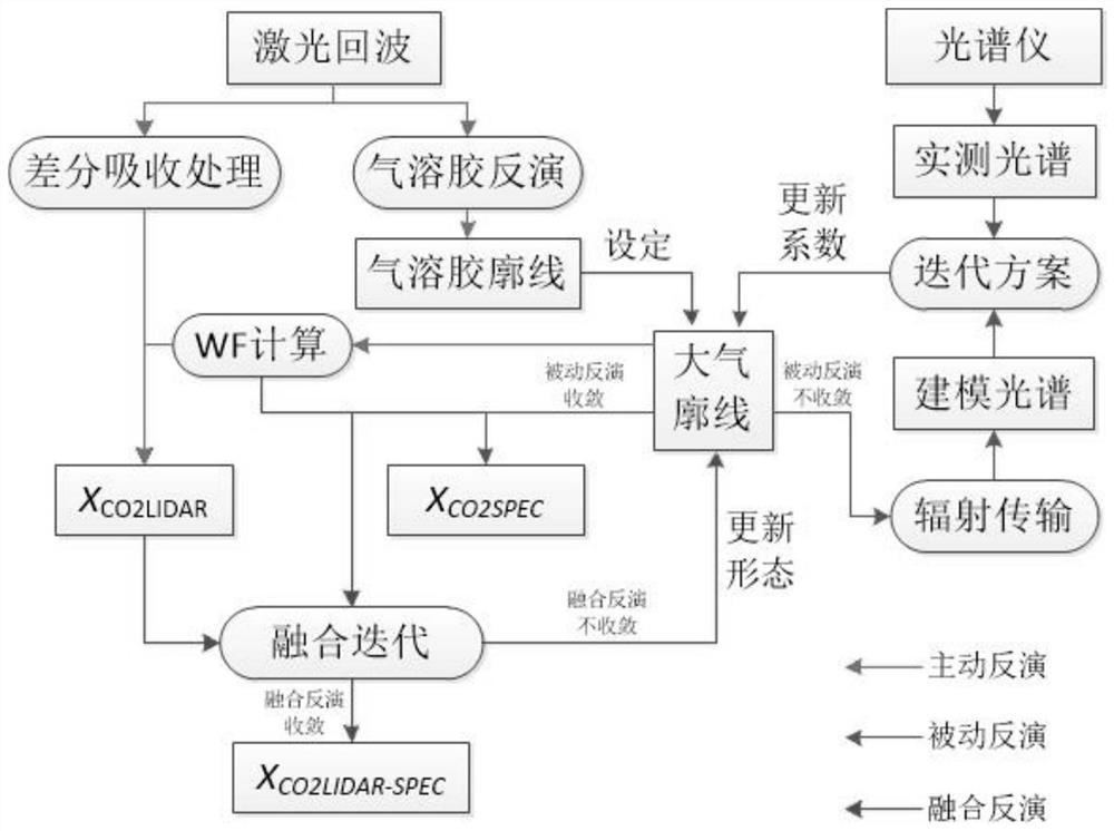
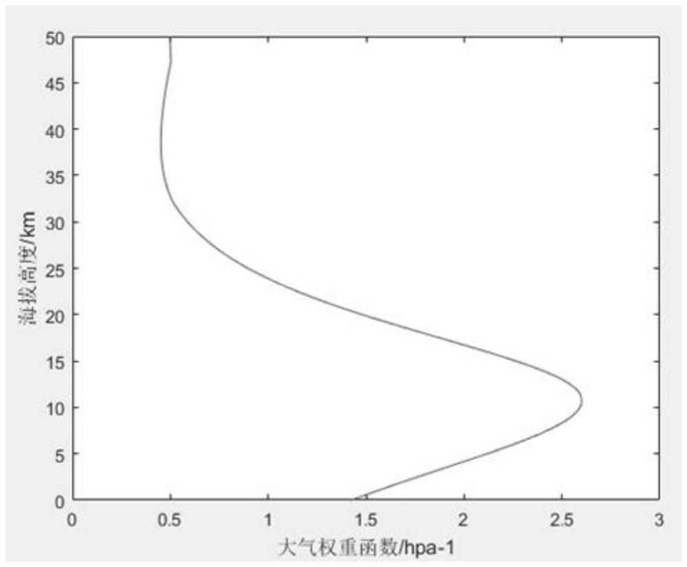
[0049] The present invention provides a coordinated inversion method for atmospheric CO2 concentration aimed at spaceborne laser radar and hyperspectral instrument. Firstly, the aerosol atmospheric profile is obtained by inversion of the laser radar 1064nm echo signal, and the CO2 column weight is calculated according to the laser radar 1572nm echo signal. Concentration, use sciatran to model atmospheric radiation, perform least squares fitting between the observed solar spectrum and the simulated value output by the sciatran model, obtain the CO2 vertical concentration profile, and then use the vertical profile as an absolute constraint to construct a loss function , set the weight of the loss function through prior observations, obtain the optimal solution that minimizes the loss function, update the atmospheric profile, and calculate the final XCO2 product with high resolution, high coverage, high precision and high availability.

[0050] The technical solutions of the prese...


PUM


Abstract

The invention relates to an atmospheric CO2 concentration coordinated inversion method for a satellite-borne laser radar and a hyperspectrometer. The method comprises the following steps: firstly, carrying out inversion by using a laser radar 1064nm echo signal to obtain an aerosol atmospheric profile, calculating the weighted concentration of a CO2 column according to a laser radar 1572nm echo signal, carrying out modeling on atmospheric radiation by using a scriatran model, carrying out least square fitting on a solar spectrum obtained by observation and an analog value output by the scriatran model to obtain a CO2 vertical concentration profile, and then taking the vertical profile as an absolute constraint to obtain a CO2 vertical concentration curve. Constructing a loss function, setting the weight of the loss function through a priori observation value, obtaining an optimal solution enabling the loss function to be minimum, updating an atmosphere profile, and calculating to obtain a final XCO2 product. According to the invention, the advantages of high detection precision and high availability of the laser radar and the advantages of high detection light coverage and high resolution of the high spectrograph are fused, so that an atmospheric CO2 column concentration product with the characteristics of high resolution, high coverage, high precision and high availability is obtained.

Description

technical field [0001] The invention belongs to the technical field of satellite remote sensing and earth observation, and in particular relates to a coordinated inversion method for atmospheric CO2 concentration aimed at space-borne laser radar and hyperspectral instrument. Background technique [0002] The space-based CO2 observation system is an important part of anthropogenic carbon emission monitoring, which has the characteristics of large spatial coverage and high temporal resolution. Since the 21st century, satellite remote sensing has also played an important role. With the successful launch of GOSAT, OCO-2 and carbon satellites, people's understanding of CO2 emissions has deepened. In recent years, the successive launches of domestic and foreign satellites such as Fengyun-3 04, Gaofen 5, OCO-3, GOSAT-2 and GHGSat series have further set off a wave of space-based atmospheric greenhouse gas monitoring. At present, these satellite products have demonstrated good appl...

Claims


Application Information

Patent Timeline
Patent Type & Authority Applications(China)
IPC IPC(8): G01S17/95G01S17/86G01S7/48
CPCG01S17/95G01S17/86G01S7/4802Y02A90/10
Inventor 韩舸蔡孟阳魏旭芃马昕龚威
Owner WUHAN UNIV
Why Eureka
Try Eureka