Over-the-mouth channel water and sediment movement and terrain evolution integral modeling and visualization system

A terrain and channel technology, applied in the field of marine informatization, can solve the problems of expensive dredging maintenance, floating mud generation, and significant back silting in the flight section, so as to ensure safe and sound operation, improve efficiency and safety, and improve economic benefits. Effect

Active Publication Date: 2022-03-22
HOHAI UNIV
View PDF5 Cites 3 Cited by
  • Summary
  • Abstract
  • Description
  • Claims
  • Application Information

AI Technical Summary

Problems solved by technology

[0004] The present invention provides an overall modeling and visualization system for water and sediment movement and terrain evolution in estuary waterways, which can effectively solve the problem that a large am

Method used


Image

  • Over-the-mouth channel water and sediment movement and terrain evolution integral modeling and visualization system
  • Over-the-mouth channel water and sediment movement and terrain evolution integral modeling and visualization system
  • Over-the-mouth channel water and sediment movement and terrain evolution integral modeling and visualization system

Examples


Embodiment 1

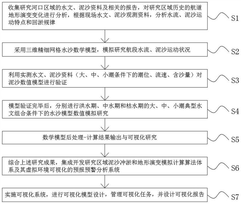
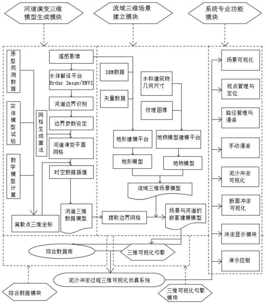
[0091] Such as Figure 1-2 As shown, the present invention provides a technical solution, the overall modeling and visualization system of water and sediment movement and its terrain evolution in the estuary channel, according to the technical requirements of the numerical test and research of water flow and sediment deposition, as well as the geographical location, topographical conditions and hydrological measurements of the water area The conditions, implementation plan and technical route are as follows:

[0092] S1. Collect and study hydrological and sediment data and related reports in the estuary area, analyze the evolution of the historical waterway topography in the research area, and analyze the characteristics of water flow, sediment movement and silting law based on on-site hydrological and sediment observation data;

[0093] S2. Use the three-dimensional fine grid water and sand mathematical model to simulate and study the water flow and sediment movement conditio...

Embodiment 2

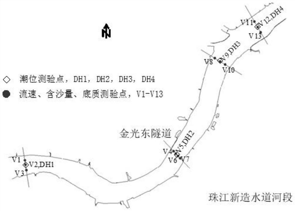
[0148] Taking the river section where the Jinguangdong Tunnel Project is located as an example, MIKE21 is used to simulate the flow and sediment movement. The specific process is as follows:

[0149] 1. Hydrological survey

[0150] like image 3 As shown, 4 flow-measuring sections are arranged in the river section where the Jinguangdong Tunnel Project is located, and 4 flow-measuring and sand-taking points are arranged on each section according to the length of the measuring line and the terrain of the river channel, and the hydrological tests of large and small tides are carried out;

[0151] The test content includes cross-section large and small tidal current velocity, flow process observation, layered sediment concentration, suspended sand particles, bed sand particles, wind speed and direction, surface water temperature, salinity, bulk density, etc. The smaller two represent tides, and each representative tide guarantees two rises and two falls to meet the requirements o...


PUM


Abstract

The invention discloses an estuary channel water and sediment movement and topographic evolution integral modeling and visualization system, and the implementation scheme and technical route are as follows: collecting hydrological and sediment data and related report data of a research estuary channel region, analyzing the topographic evolution change of the research region, and determining the topographic evolution of the research region according to the on-site hydrological and sediment observation data. And analyzing the movement characteristics of water flow and sediment and the back-silting rule. According to the channel terrain evolution modeling simulation and virtual environment visualization system, through fusion with technologies such as the Internet of Things, cloud computing and big data, ports and piers related to channels can be constructed into modern intelligent ports, the efficiency and the safety degree are greatly improved, and the system is suitable for popularization and application. A worker and a decision maker can check the sediment deposition situation of the channel at any time and monitor the evolution trend of the terrain at the bottom of the channel, so that optimization measures can be taken in advance, economic benefits are improved, and safe and good operation of shipping is guaranteed.

Description

technical field [0001] The invention relates to the technical field of marine informatization, in particular to an overall modeling and visualization system for water and sand movement in estuary waterways and its terrain evolution. Background technique [0002] Dredging engineering refers to the use of dredgers or other machines and manual underwater excavation to widen and deepen the water area. The stress diagram of the excavation design of the dredging engineering causes changes in the internal structure of the water flow by changing the geometric boundary of the river channel. , so that the newly formed water flow structure can not only ensure that the sediment will no longer deposit in the channel (at least before the next flood season), but also transport the sediment entering the excavated trench to the lower deep trench to maintain The waterway is stable. The third phase of the Changjiang Estuary Deepwater Channel Improvement Project started in September 2006. The t...

Claims


Application Information

Patent Timeline
IPC IPC(8): G06F30/23G06F111/10
CPCG06F30/23G06F2111/10Y02A10/40
Inventor 吴德安陈广
Owner HOHAI UNIV
Why Eureka
Try Eureka