Method of generating simulated airborne fire control radar ground surveying and mapping image based on dem data

An airborne fire control and data generation technology, applied in measurement devices, radio wave measurement systems, instruments, etc., can solve problems such as high price, inconvenient simulation, functional limitations, etc., and achieve high real-time performance, good simulation effect and efficiency. high effect

Active Publication Date: 2022-05-10
南京雷电信息技术有限公司
View PDF14 Cites 0 Cited by
  • Summary
  • Abstract
  • Description
  • Claims
  • Application Information

AI Technical Summary

Problems solved by technology

The commercial radar imaging simulation software used for simulation training on the market is mostly foreign products, such as the radar simulation software Radar Toolkit from American Camber Company, and the professional toolkit SE-Workbench-RF from French OKTAL-SE Company, etc. Expensive, difficult to purchase, and limited in function, it is not convenient to carry out simulation in combination with the actual training needs of our country

Method used


Image

  • Method of generating simulated airborne fire control radar ground surveying and mapping image based on dem data
  • Method of generating simulated airborne fire control radar ground surveying and mapping image based on dem data
  • Method of generating simulated airborne fire control radar ground surveying and mapping image based on dem data

Examples


Embodiment Construction

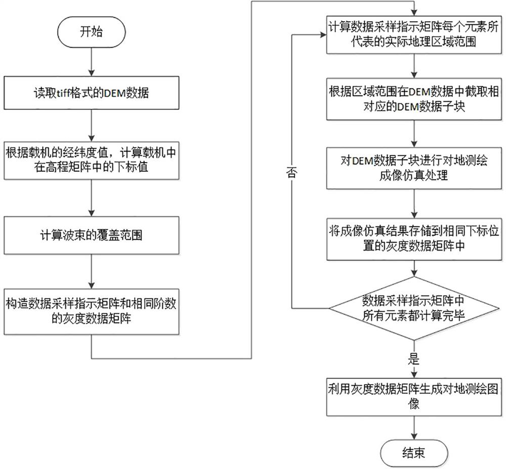
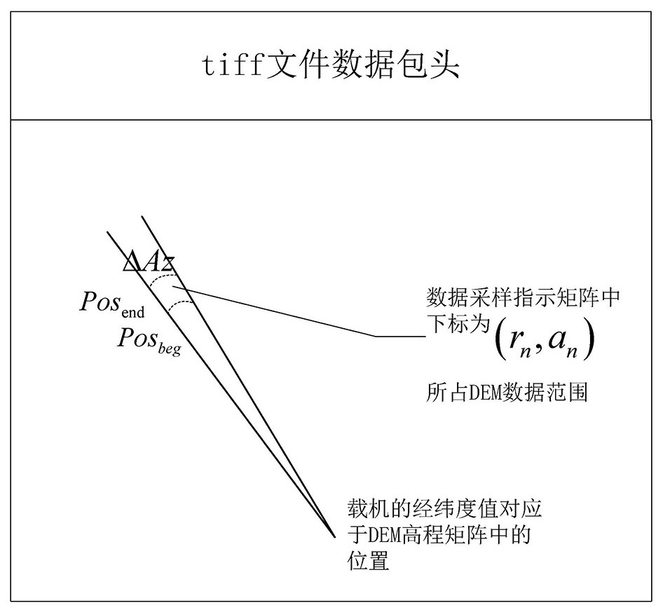
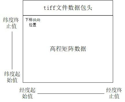
[0061] The technical solutions of the present invention will be described in detail below with reference to the accompanying drawings, but the protection scope of the present invention is not limited to the embodiments.

[0062] The improvement of the azimuth resolution capability of DBS mode for ground surveying and mapping is based on the Doppler resolution theory, that is, the Doppler information in the echo is used to divide the echo signal in the frequency domain, which is equivalent to subdividing the real antenna beam. Therefore, it can be seen that the DBS imaging effect can be equivalent to the beam width of The real beam mapping of , where is the true beamwidth, is the sharpening ratio. In addition, according to the Doppler resolution theory, in the direction of the velocity vector of the aircraft, the Doppler bandwidth of the radar is 0, so in this direction, the Doppler information cannot be used to subdivide the real antenna beam, that is, the imaging cannot ...


PUM


Abstract

The method for generating simulated airborne fire control radar ground surveying and mapping images based on DEM data disclosed by the present invention comprises the following steps: reading the DEM data in tiff format, calculating the subscript position in the elevation matrix of the DEM data corresponding to the latitude and longitude value of the carrier aircraft; determining The radar beam covers the starting distance and the ending distance; constructs a two-dimensional data sampling indicator matrix and a grayscale data matrix; calculates the actual geographical area represented by each element in the data sampling indicator matrix, and intercepts the corresponding area in the DEM data according to the area range DEM data sub-blocks, and then perform ground surveying and mapping imaging simulation processing for each DEM data sub-block, and store the imaging simulation results in the grayscale data matrix elements at the same subscript position; finally use the grayscale data matrix to calculate and generate a pair of Mapping images. The invention can realize real-time generation of two-dimensional large-area surveying and mapping image information in front of the aircraft along with the radar beam scanning according to the flight track of the fighter.

Description

technical field [0001] The invention relates to the technical field of large-area ground surveying and mapping by airborne fire control radars, in particular to a method for generating simulated ground surveying and mapping images by airborne fire control radars based on DEM data. Background technique [0002] The large-area ground surveying and imaging function of the airborne fire control radar is used to realize the two-dimensional imaging processing of the ground scene in a large area (up to hundreds of kilometers) in front of the aircraft. It has two methods, one is Real Beam Mapping (RBM), and the other is Doppler Beam Sharpening (DBS). The RBM mode directly uses the echo signal strength received by the radar to draw a two-dimensional image of the ground, and the azimuth resolution is close to the actual radar beam width; the DBS mode utilizes the fact that different angles within the beam will produce different Doppler frequencies. The principle is to further subdivi...

Claims


Application Information

Patent Timeline
Patent Type & Authority Patents(China)
IPC IPC(8): G01S13/933G01S13/90G01S13/08G01S7/41
Inventor 郑云马志强柯树林冷盛林
Owner 南京雷电信息技术有限公司
Why Eureka
Try Eureka