Highway guardrail vectorization method and device based on vehicle-mounted LIDAR data

A highway and vectorization technology, applied in the field of intelligent transportation, can solve the problems of unavailability, mass introduction, unfavorable point cloud data processing, etc., to reduce redundancy, save storage space, and improve accuracy.

Active Publication Date: 2022-07-22
SICHUAN DEPT OF TRANSPORTATION HIGHWAY PLANNING PROSPECTING & DESIGN RES INST
View PDF12 Cites 0 Cited by
  • Summary
  • Abstract
  • Description
  • Claims
  • Application Information

AI Technical Summary

Problems solved by technology

[0005] However, there are three major disadvantages in the existing method: 1. The calculation accuracy and efficiency of the local radar point cloud data acquired in real time are seriously affected by the field of view of the sensor, which is only conducive to the detection of obstacles within a short field of view of driving, and cannot be applied to long-distance guardrails. 2. Only based on the combined judgment conditions of obstacle probability and relative lateral velocity, the pure identification and extraction of road guardrail point cloud data cannot be realized, and a large number of environmental noise point clouds such as vegetation and other static traffic safety facilities will be introduced data, which is not conducive to the further processing of subsequent point cloud data; 3. Directly performing curve fitting calculations on all point cloud data of the guardrail will not be able to obtain an accurate spatial position of the centerline of the road guardrail, which will seriously affect the accuracy of the true direction of the guardrail line. Related calculations The results cannot be used for the implementation of a series of expressway digitalization technologies such as high-precision expressway map production and rapid 3D reconstruction of real scenes based on trajectory lines

Method used


Image

  • Highway guardrail vectorization method and device based on vehicle-mounted LIDAR data
  • Highway guardrail vectorization method and device based on vehicle-mounted LIDAR data
  • Highway guardrail vectorization method and device based on vehicle-mounted LIDAR data

Examples


Embodiment 1

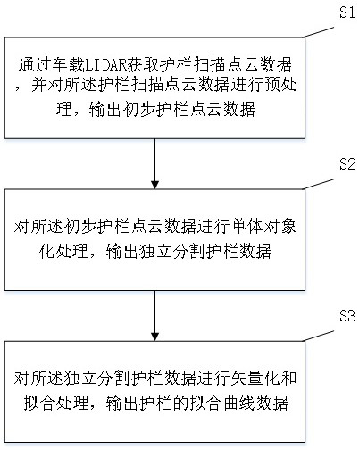
[0082] like figure 1 As shown, a method for extracting highway guardrails based on vehicle LIDAR data includes the following steps:

[0083] S1: Obtain the guardrail scanning point cloud data through the vehicle-mounted LIDAR, preprocess the guardrail scanning point cloud data, and output preliminary guardrail point cloud data; the preprocessing is to use the RandLA-Net algorithm to scan the guardrail point cloud data Perform semantic segmentation and extract preliminary guardrail point cloud data;

[0084] S2: Perform single objectization processing on the preliminary guardrail point cloud data, and output accurate and independently segmented guardrail data; the single objectization includes normalization, rough segmentation, and fine segmentation;

[0085] S3: Perform vectorization and fitting processing on the independently segmented guardrail data, and output the fitting curve data of the guardrail; the vectorization includes center point extraction and center point thinn...

Embodiment 2

[0087] This embodiment is a detailed description of the method described in Embodiment 1, including:

[0088] S1: Obtain the guardrail scanning point cloud data through the vehicle-mounted LIDAR, preprocess the guardrail scanning point cloud data, and output preliminary guardrail point cloud data.

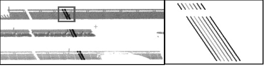
[0089] Use vehicle-mounted LIDAR to obtain massive highway scene point cloud data, covering a variety of highway asset elements, mainly including: pavement, signage, guardrail, vegetation, etc. All kinds of elements are interlaced and closely connected, and it is impossible to effectively distinguish different elements. , the overall clustering extraction of the guardrail point cloud is required to provide a reliable data basis for the independent segmentation of the guardrail point cloud and the trajectory curve fitting. Therefore, the data preprocessing is mainly the semantic segmentation of guardrail point clouds. The experimental results show that RandLA-Net has shown very good...

Embodiment 3

[0149] This embodiment is a specific experimental example using the method described in Embodiment 2. The experiment uses three sets of data sets of different road section environments to verify and analyze the method proposed in this patent. Image 6 As shown, the three sets of data contain typical highway scenes: curve scenes (such as Image 6 a), complex ramp scenarios (such as Image 6 b) as well as straight-line scenarios (such as Image 6 c and Image 6 d). For these three sets of data, the method of this patent is used to verify the data and judge the accuracy.

[0150] The experimental results are as Figure 7 As shown, it can be seen that the method proposed in this patent is aimed at the curve ( Figure 7 a) and the ramp area ( Figure 7 b) has certain advantages, and the effect of single guardrail is significant; while for straight sections ( Figure 7 c and d), the boundaries between the guardrails are clear, although the data of each guardrail is missing, t...


PUM


Abstract

The invention relates to the field of intelligent transportation, in particular to an expressway guardrail vectorization method and device based on vehicle-mounted LIDAR data. According to the method, data extraction is carried out on the highway guardrail through vehicle-mounted LIDAR (Light Detection and Ranging), guardrail data elements can be effectively extracted, noisy points and mistaken points occurring in the extraction process are reduced, and meanwhile the integrity of the guardrail is effectively reserved. Through carrying out single objectification processing on guardrail LIDAR scanning data, single separated expression can be carried out on an expressway boundary guardrail and a center guardrail, so that the expressway boundary guardrail and the center guardrail have independent entity information; vectorization is carried out on independent segmentation guardrail data in a three-dimensional coordinate system, data redundancy is effectively reduced, finally, the data redundancy is reduced according to fitting processing, meanwhile, a curve is smoother, more storage space is saved, the data fitting precision is effectively improved, and the data fitting efficiency is improved. And an important basic technical support is provided for implementation of a series of technologies of subsequent highway digital construction.

Description

technical field [0001] The invention relates to the field of intelligent transportation, in particular to a method and device for vectorizing highway guardrails based on vehicle-mounted LIDAR data. Background technique [0002] As one of the infrastructures of the expressway, the guardrail is an important road boundary constraint facility. In many traffic informatization applications such as smart expressway construction and expressway high-precision map production, the spatial position and direction of guardrails are used as important boundary benchmarks for the digital base of expressways. Now, the digitization of conventional expressway guardrails mainly relies on manual interaction vectorization. After the drawing is completed, the operation efficiency is low, and the level of vectorization accuracy varies with the operator, which cannot be applied to the implementation of the digital standardization technology of expressway infrastructure. [0003] 3D laser scanning is...

Claims


Application Information

Patent Timeline
Patent Type & Authority Applications(China)
IPC IPC(8): G06V20/58G06V10/26G06V10/30G06T17/30
CPCG06T17/30
Inventor 贾洋李升甫廖知勇刘蕾蕾孙璐杨天宇杨洪贾鑫南轲刘霜辰许濒支李艳玲易菊平倪愿罗文韬
Owner SICHUAN DEPT OF TRANSPORTATION HIGHWAY PLANNING PROSPECTING & DESIGN RES INST
Why Eureka
Try Eureka