
Airborne liDAR point cloud semantic segmentation method, electronic equipment and storage medium

A semantic segmentation and point cloud technology, applied in the field of remote sensing image processing, can solve the problems of low classification accuracy of small-scale targets, difficulty in improving classification accuracy, and reduced algorithm classification accuracy, etc., to enhance scale perception and enhance geometric characteristics Understanding and Improving the Effect of Semantic Connotation

Active Publication Date: 2022-07-29
HUNAN SHENGDING TECH DEV CO LTD
View PDF10 Cites 0 Cited by
  • Summary
  • Abstract
  • Description
  • Claims
  • Application Information

AI Technical Summary

Problems solved by technology

Faced with the complex geometric structure of the airborne LiDAR point cloud, the model input of a single attribute will lead to a decrease in the classification accuracy of the algorithm. How to improve the network's ability to perceive the geometric structure of the point cloud and the fine types of ground objects is the key to further improving the classification accuracy.
At the same time, the scales of different types of ground objects in the airborne LiDAR point cloud are different. If the deep learning network that ignores the differences in multi-scale features will lead to a low classification accuracy rate of small-scale targets, it is difficult to improve the overall classification accuracy rate.

Method used


Image

  • Airborne liDAR point cloud semantic segmentation method, electronic equipment and storage medium
  • Airborne liDAR point cloud semantic segmentation method, electronic equipment and storage medium
  • Airborne liDAR point cloud semantic segmentation method, electronic equipment and storage medium

Examples


Embodiment Construction

[0058] The technical solutions in the present invention will be clearly and completely described below with reference to the accompanying drawings in the embodiments of the present invention. Obviously, the described embodiments are only a part of the embodiments of the present invention, rather than all the embodiments. Based on the embodiments of the present invention, all other embodiments obtained by those of ordinary skill in the art without creative work fall within the protection scope of the present invention.

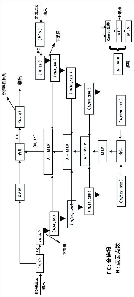
[0059] An airborne LiDAR point cloud semantic segmentation method provided by the embodiment of the present invention first obtains LiDAR point cloud data and hyperspectral data from an airborne platform; then uses the hyperspectral image as a reference coordinate to project the LiDAR point cloud to the hyperspectral image On the image (that is, coordinate alignment), and back-project the hyperspectral data to the LiDAR point cloud through the projection relatio...


PUM


Abstract

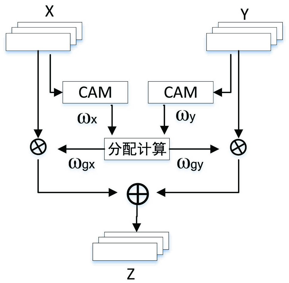
The invention discloses an airborne liDAR point cloud semantic segmentation method, and the method comprises the steps: carrying out the fusion of a LiDAR point cloud and a hyperspectral image, and obtaining a hyperspectral point cloud; performing feature extraction on each group of LiDAR point cloud data to obtain a first feature vector; encoding each group of LiDAR point cloud data and hyperspectral point cloud data to obtain a LiDAR point cloud feature vector and a hyperspectral feature vector of each encoding stage; fusing the LiDAR point cloud feature vector and the hyperspectral feature vector of the current coding stage with the fusion feature vector of the previous decoding stage by adopting an A-MLP layer, inputting the fused feature vector and the fused feature vector into the next decoding stage, and obtaining a second feature vector after decoding is completed; and after the first feature vector and the second feature vector are spliced, the third feature vector is obtained through full connection layer calculation, and each point is segmented and labeled according to the third feature vector, so that the classification accuracy of the complex scene is improved.

Description

technical field [0001] The invention belongs to the technical field of remote sensing image processing, and in particular relates to an airborne liDAR point cloud semantic segmentation method based on hyperspectral-spatial enhancement, an electronic device and a storage medium. Background technique [0002] With the wide application of unmanned aerial vehicle, lidar, and spectral technology, the use of low-altitude remote sensing technology to directly obtain three-dimensional space and hyperspectral information has gradually become a research hotspot in the fields of surveying, mapping and agriculture. Airborne LiDAR technology has been widely used in the extraction of digital elevation models (DEM), digital surface models (DSM), and forest vegetation statistics. Point cloud (three-dimensional space) semantic segmentation is the basis of point cloud processing technology. High-accuracy segmentation and classification of ground objects in airborne LiDAR point clouds is a key...

Claims


Application Information

Patent Timeline
IPC IPC(8): G06V10/26G06V10/40G06V10/764G06V10/80G06V10/82G06K9/62G06N3/04G06N3/08
CPCG06V10/26G06V10/806G06V10/82G06V10/40G06V10/764G06N3/08G06N3/045G06F18/241G06F18/253
Inventor 李修庆赵健康王怀採蔡晓程谢才望孔令威赵丽芝
Owner HUNAN SHENGDING TECH DEV CO LTD
Learn More