Managed traverse system and method to acquire accurate survey data in absence of precise GPS data

a traverse system and survey data technology, applied in the field of system and method for obtaining precise surveygrade position data, can solve the problems of inability to use current generation gps survey instruments, gps survey instruments with even shorter range limits, and requiring elaborate and time-consuming installations, so as to reduce the accumulation of tracking errors

Active Publication Date: 2007-06-21
TRIMBLE NAVIGATION LTD
View PDF13 Cites 71 Cited by
  • Summary
  • Abstract
  • Description
  • Claims
  • Application Information

AI Technical Summary

Benefits of technology

[0044] an aiding device for reducing the accumulated tracking errors during traversing to the target inside the zone by determining position relative to at least one reference location whose position is known.

Problems solved by technology

Fan lasers have even shorter range limits and require elaborate and time-consuming installations.
The GPS survey instrument's accuracy reliability diminishes when one or more signal lines of sight pass through foliage.
Hence the current generation GPS survey instrument is unusable near trees or buildings that can shade, reflect or refract the GPS signals.
More precisely, a precise-GPS-denied zone is a zone or region where a GPS surveyor cannot provide the required accuracy in locating a point in three dimensional space (for example, accuracy may degrade from 1 cm to 3 cm in a precision land survey due to signal refraction from nearby foliage or buildings).
This describes the fact that although a GPS receiver may continue to provide a position solution, it cannot reliably provide a precise survey-grade position solution which has centimeter-level accuracy.
This leads into the technical dimension of the problem.

Method used


Image

  • Managed traverse system and method to acquire accurate survey data in absence of precise GPS data
  • Managed traverse system and method to acquire accurate survey data in absence of precise GPS data
  • Managed traverse system and method to acquire accurate survey data in absence of precise GPS data

Examples


Embodiment Construction

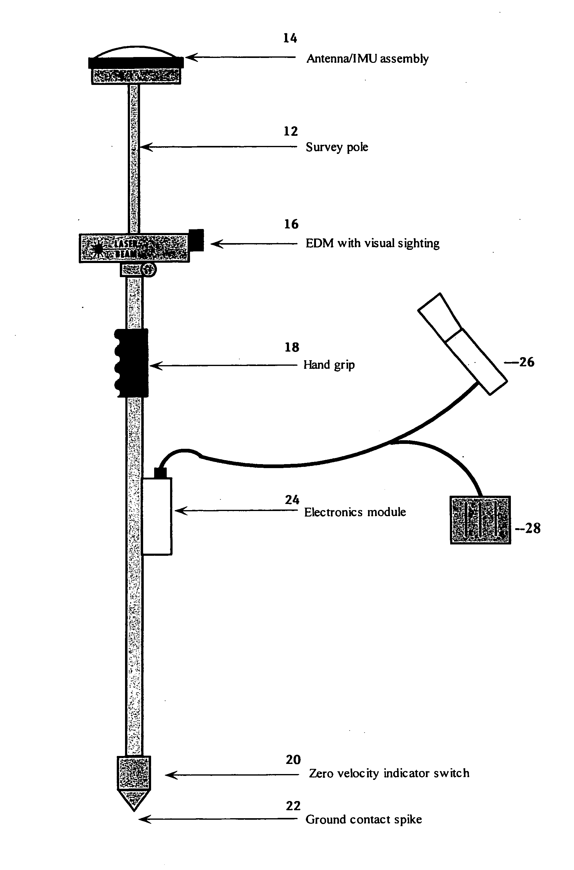
[0053] The present invention provides a method of determining the position of a target comprising the steps of determining the position of a starting point spaced apart from the target, traversing from the starting point to the target while keeping track of positions using a tracking method that is subject to the accumulation of tracking errors, and en route to the target, reducing the accumulated errors by determining position relative to at least one reference location.

[0054] The reference location may be the starting point or may be spaced apart from the starting point.

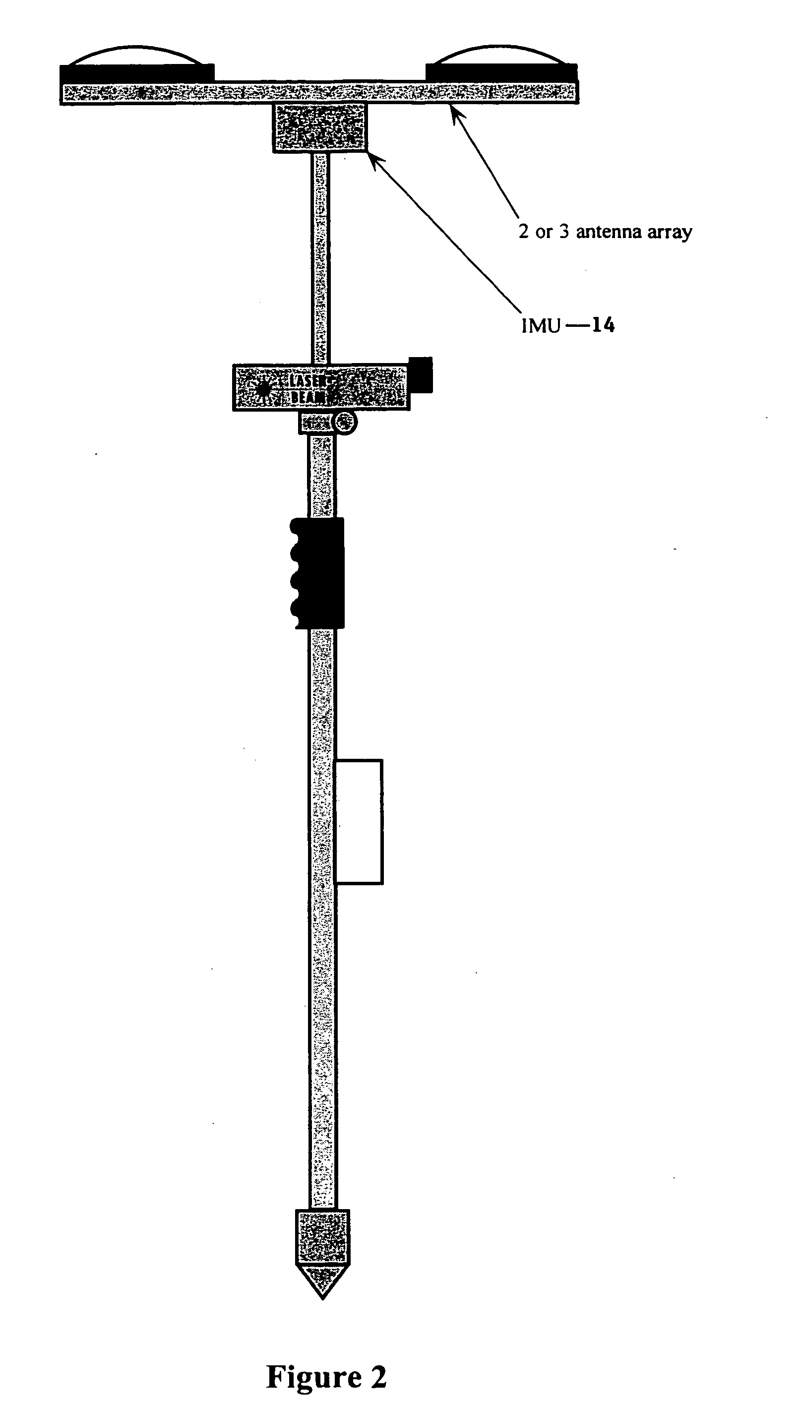
[0055] The step of determining the position of a starting point may comprise using a GPS receiver. The step of traversing may use a tracking method with an IMU. The step of reducing accumulated errors may comprise obtaining aiding information with an EDM.

[0056] The invention provides a method of determining the location of an object in a zone, comprising: [0057] a. defining a first reference point near the perim...


PUM


Abstract

A method and system obtains precise survey-grade position data of target points in zones where precise GPS data cannot be obtained, due to natural or man-made objects such as foliage and buildings. The system comprises a GPS receiver mounted on a survey pole, with an inertial measurement unit (IMU) and an electronic distance meter (EDM) also mounted on the pole. The system and method obtains GPS data when outside the zone and uses the IMU inside the zone to traverse to a target point, using the EDM to obtain data reduce accumulated errors which occur with the IMU.

Description

BACKGROUND OF THE INVENTION [0001] The present invention is directed to a system and method for obtaining precise survey-grade position data, particularly in areas or zones where precise GPS data cannot be obtained, due to natural or man-made objects such as trees and buildings. [0002] An open technical milestone within the geomatics community is the extension of precise positioning with a GPS survey instrument into areas where some or all of the signals from the GPS satellites are perturbed. This problem has several dimensions that include the technical dimension, the economic dimension and the man-machine interface (MMI) dimension. [0003] The economic dimension is the GPS survey instrument's value proposition that justifies its price of $35K-50K. The value proposition is the significant improvement in efficiency over alternative precise positioning methods that include conventional total stations (CTS), automatic total stations (ATS) and fan lasers. A GPS survey instrument require...

Claims


Application Information

Patent Timeline
Patent Type & Authority Applications(United States)
IPC IPC(8): G01S5/14G01C21/00G01S19/49G01S19/51
CPCG01C15/00G01C15/06G01C21/165G01S19/49G01S19/51G01S19/485
Inventor SCHERZINGER, BRUNO
Owner TRIMBLE NAVIGATION LTD
Why Eureka
Try Eureka