High-Capacity Location and Identification System for Cooperating Mobiles With Frequency Agile and Time Division Transponder Device on Board

a technology of frequency agile and identification system, which is applied in the direction of measurement device, radio wave reradiation/reflection, using reradiation, etc., can solve the problems of inability to analyze, inability to detect, and inability to detect, etc., and achieve the effect of improving the operation

Inactive Publication Date: 2008-05-08
UNIVERSITY OF ROME TOR VERGATA
View PDF7 Cites 29 Cited by
  • Summary
  • Abstract
  • Description
  • Claims
  • Application Information

AI Technical Summary

Benefits of technology

[0028]The present invention overcomes, with innovative approaches, the limitations prior to the invention itself as described in the previous paragraphs. It permits a noticeable improvement of the operation of the SSR-based systems (including the MLAT, the WAM, and, most important, the NTD equipment and the related Advanced Vehicle Management System or AVMS for short) in terms of capacity and continuity of the service. In particular, the state of the art limitations previous of the present invention are overcome by a new signal generator in the transponder device, that can be defined “with frequency agility and time division” because (a) the central transmitted frequency is variable, within the already mentioned ICAO standards, in every new emission of the transponder within a number of disjoint bands, and (b) the transmission is allocated in time slots different from transponder to transponder in such a way that each SSR Mode S signal reaches any receiving station of the MLAT / WAM system in a time that is different enough from any other SSR Mode S signal to avoid any overlapping in time.

Problems solved by technology

This probability may be exceedingly low.
Anyway, it has been found by experience that conventional degarbling techniques permit a correct decoding with a good probability for the leading reply of two superimposed replies only for a moderate degree of superimposition; their effectiveness is particularly limited in the Multilateration systems whose receiving stations, for cost reasons, are not equipped with many receiving channels nor use the monopulse technique.
Moreover, these algorithms are effective when there is at least a part of the leading signal free from superimposition, i.e. are not suited to complete—or nearly complete—overlapping situations.
The previously mentioned patent [6] permits to overcome the limits with a frequency analysis, but this analysis will be, in the near future, less and less effective due to the increase of the quality and performance of commercial transponders in terms of stability and precision of the emitted central frequency with respect to the ICAO nominal frequency of 1090 MHz.
Furthermore, the transponder capacity as a communication and surveillance element with transmission to a receiving station (known as downlink transmission) of the relevant data of airplanes or vehicles is limited by the use of only one nominal carrier frequency, i.e. the 1090 MHz as defined by the ICAO regulations, in contrast with a receiver frequency band which, due to the transponder transmission carrier frequency tolerances, is much greater (as much as 3 to 5 times) than the frequency band associated to the information contents of the SSR signal.
In particular, present-day techniques fail to permit simultaneous identification and location of all service vehicles (such as those needed for handling operations, maintenance, survey of runways and taxiways, fire brigade, police etc.) operating in a big airport, whose number may be as large as a thousand.
As a matter of fact, state-of-the art techniques—based on radio modem or wireless LAN—do not permit the transmission of the relevant quantity of data needed for complete airport surveillance with the required data rate (one update per second), nor they satisfy the required values for integrity, continuity and availability; moreover, they do not guarantee not to exceed a maximum value for the latency time of the surveillance information, which is of course a safety-critical item.
A basic limitation of the state of the art is the random transmission time of squitter by ground vehicles and aircraft.

Method used


Image

  • High-Capacity Location and Identification System for Cooperating Mobiles With Frequency Agile and Time Division Transponder Device on Board
  • High-Capacity Location and Identification System for Cooperating Mobiles With Frequency Agile and Time Division Transponder Device on Board
  • High-Capacity Location and Identification System for Cooperating Mobiles With Frequency Agile and Time Division Transponder Device on Board

Examples


Embodiment Construction

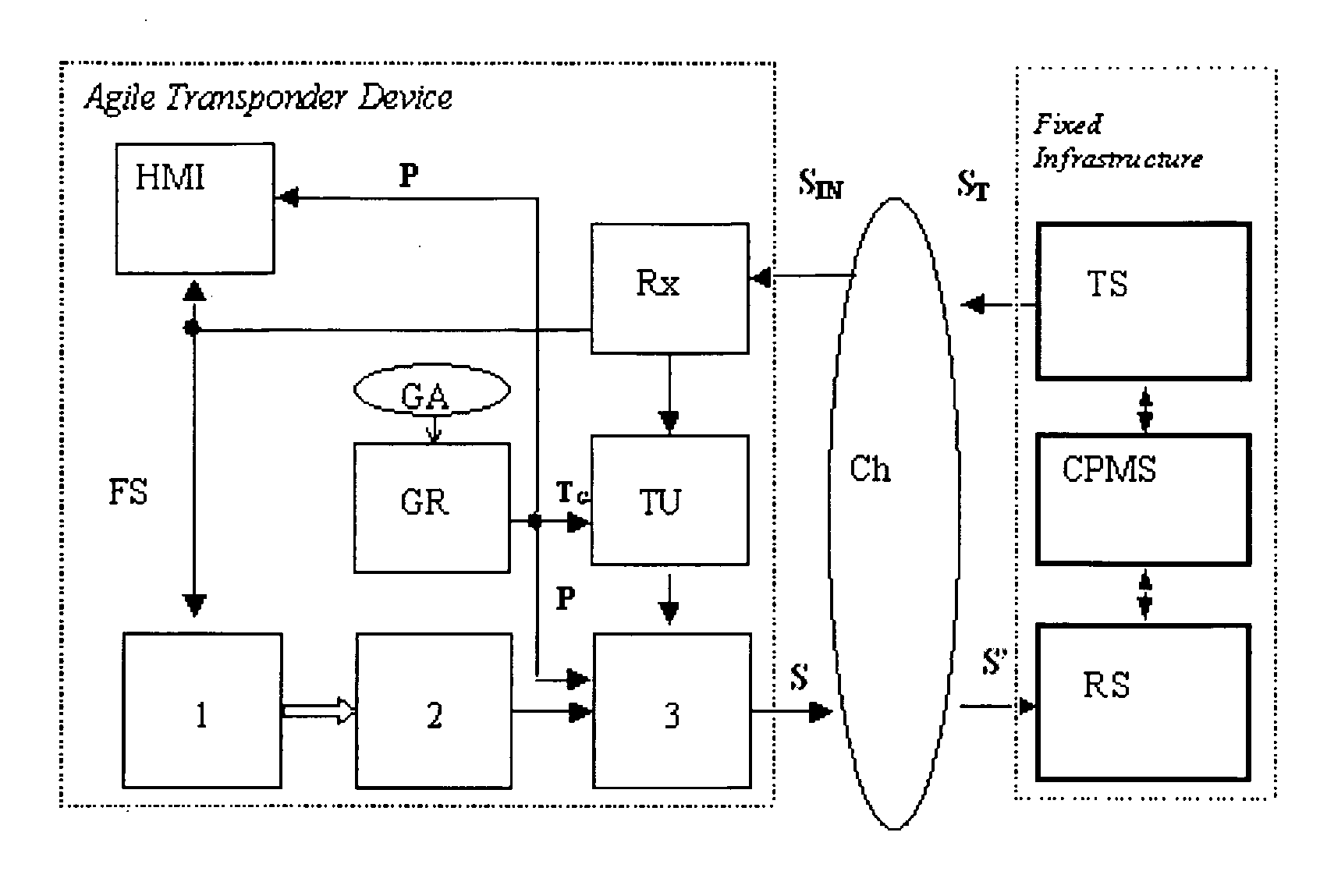
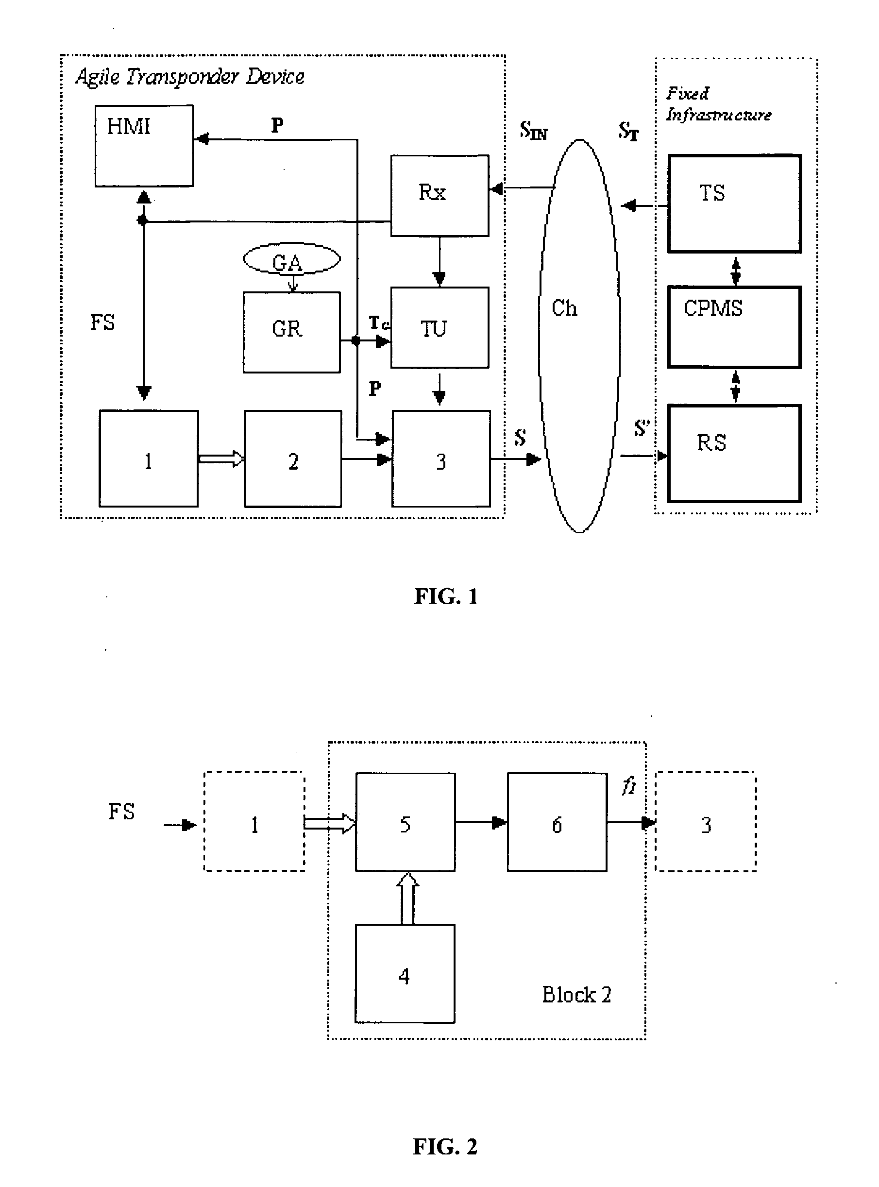
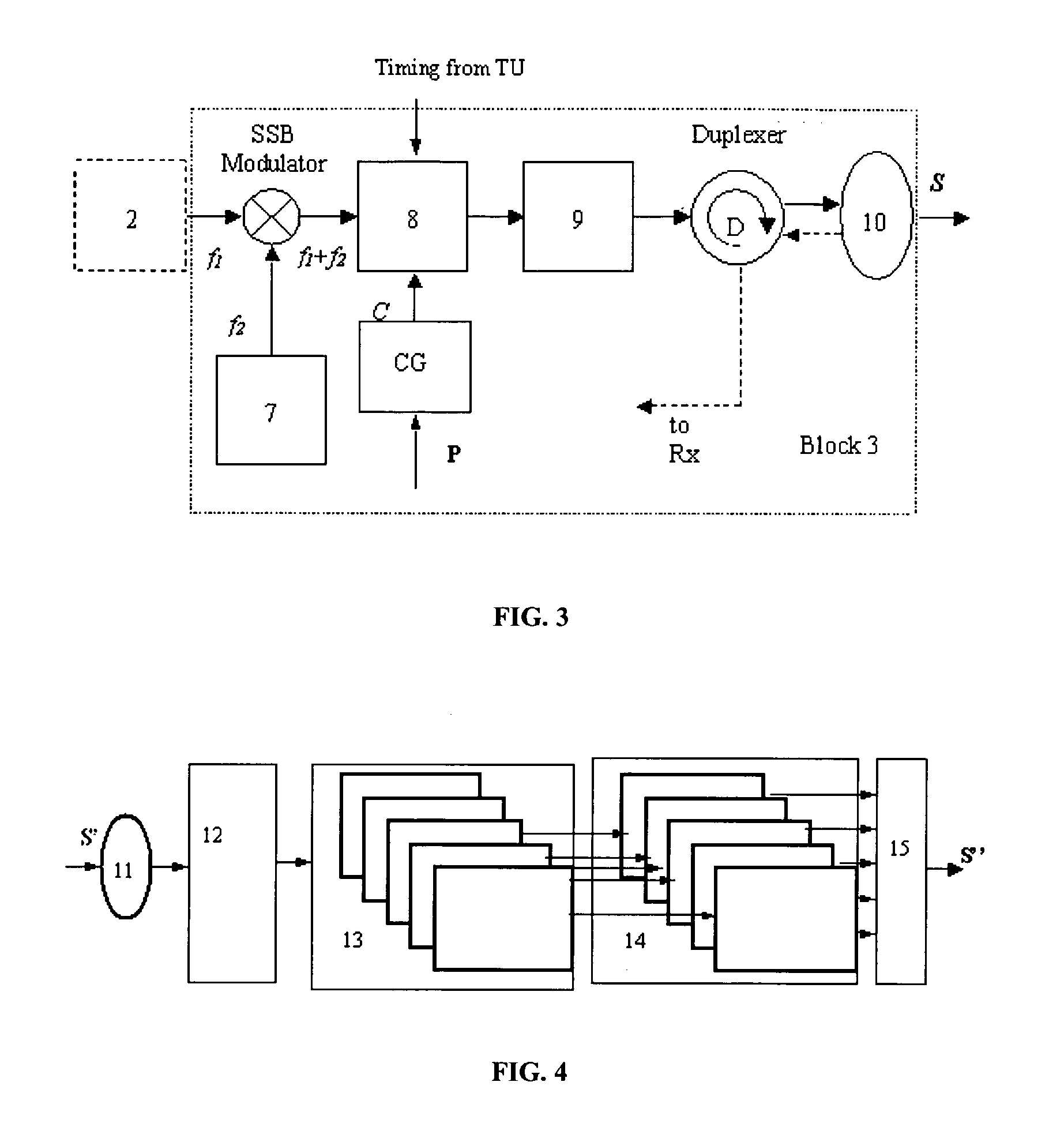
[0042]This invention is a system capable of locating and identifying a large number (e.g. thousands) of vehicles or aircraft, or any mix of vehicles and aircraft, being each vehicle or aircraft equipped with a suitable transponder. It is also capable of locating and identifying a large number (e.g. thousands) of vessels. This invention allows cooperating mobiles of civil traffic (ground vehicles, aircraft) to be located and identified by Multilateration (MLAT) and Automatic Dependent Surveillance-Broadcast (ADS-B) techniques using the Secondary Surveillance Radar (SSR) signals in high traffic situations, such as those of large airports. Standard messages, transmitted by the mobile on the downlink channel, i.e. to a set of fixed receiving stations, and including the identification code, permit the location of the mobile by multiple time measurements (Multilateration) from a number of the set of fixed receiving stations; when the message contains the position (GPS and, later, Galileo ...


PUM


Abstract

Cooperating mobiles (ground vehicles, aircraft) are located and identified by Multilateration and Automatic Dependent Surveillance-Broadcast (ADS-B) techniques using the frequency band and the format of the Secondary Surveillance Radar (SSR) signals in high traffic situations. Standard messages, transmitted by the mobile on the downlink channel, i.e. to a set of fixed receiving stations, and including the identification code, permit the location of the mobile by multiple time measurements (Multilateration) from a subset of the set of fixed receiving stations; when the message contains the position (GPS and, later, Galileo datum) the mobile may be located with the ADS-B when in view even of a few stations or of a single station. In order to overcome the problem that arises with high traffic, i.e. the superimposition of signals, called garbling.

Description

FIELD OF THE INVENTION[0001]This invention allows cooperating mobiles (ground vehicles, aircraft) to be located and identified by Multilateration and Automatic Dependent Surveillance-Broadcast (ADS-B) techniques using the frequency bands and the standard messages of the Secondary Surveillance Radar (SSR) and in particular of the SSR Mode S (Mode Selective) in high traffic situations. Standard messages, transmitted by the mobile on the downlink channel, i.e. to a set of fixed receiving stations, and including the identification code, permit the location of the mobile by multiple time measurements (Multilateration) from a number of those receiving stations; when the message contains the position (GPS datum, and, in the future, the more accurate and reliable Galileo datum) the mobile may be located when in view of a few stations or even of a single station. Cooperative location of the mobile is performed by means of the standard SSR transponder on board of airplanes (SSR transponder co...

Claims


Application Information

Patent Timeline
Patent Type & Authority Applications(United States)
IPC IPC(8): G01S13/78
CPCG01S13/784G01S13/781
Inventor BARTOLINI, SIMONEGALATI, GASPARE
Owner UNIVERSITY OF ROME TOR VERGATA
Why Eureka
Try Eureka