Method and system for locating and navigating a target

Active Publication Date: 2009-05-28
HAILO TECH LLC
View PDF5 Cites 39 Cited by
  • Summary
  • Abstract
  • Description
  • Claims
  • Application Information

AI Technical Summary

Benefits of technology

[0012]In one aspect, the present invention meets some or all of the above-mentioned needs by providing a method for traversing at least a portion of a trajectory by acquiring one or more waypoints of the trajectory, providing a plurality of beacons so that a target traversing the at least a portion of the trajectory can range to a plurality of the plurality of beacons, associating one or more beacons in one or more subsets with one or more waypoints, ranging by the target to one or more beacons in one or more subsets associated with one or more waypoints, where the one or more subsets ranged to is the one or more subsets associated with one or more waypoints the target is in close proximity to compared to the other waypoints, and traversing at least a portion of the trajectory by the target by using range data from one or more beacons in one or more subsets associated with one or more waypoints.
[0013]This aspect of the invention may be further characterized by one or any combination of the following features or steps: determining or acquiring confidence indicators for range measurements derived from one or more beacons for one or more waypoints; communicating confidence indicators, where the confidence indicators may be at least in part determined using a Euclidean norm calculation, may be at least in part determined using signal strengths of the signals (signal strength can equate to signal quality) used to determine the range measurements; storing the confidence indicators for later use or modification; associating one or more beacons in one or more subsets with one or more waypoints comprises associating based upon confidence indicators, where one or more beacons comprising a subset for a waypoint have larger (higher) confidence indicators than other beacons when ranging with the target at the waypoint; prioritizing beacons by confidence indicators, where beacons with larger confidence indicators are prioritized over beacons with smaller confidence indicators; calculating weighted values for one or more beacons by comparing confidence indicators of one or more beacons with other beacons for one or more waypoints, using the weighted values to determine the influence that the range measurements have in determining the position of the target; calculating voting values for one or more beacons corresponding to confidence indicators of range measurements derived from one or more beacons for one or more waypoints, using the voting values for one or more beacons for one or more waypoints to determine which beacons comprise one or more subsets associated with one or more waypoints; or calculating offset values for one or more beacons based upon error values of range measurements derived from one or more beacons for one or more waypoints, using the offset values for one or more beacons to adjust range measurements for one or more beacons for one or more waypoints.
[0014]In another aspect, the invention is contemplated to cover a method for traversing at least a portion of an area which may comprise mapping the area into a plurality of cells; providing a plurality of beacons throughout the area; associating one or more beacons in one or more subsets with one or more cells; ranging by a target to one or more beacons in one or more subsets associated with one or more cells; wherein the one or more subsets ranged to is the one or more subsets associated with one or more cells the target is located within or in close proximity to compared to other cells, and traversing at least a portion of the area by the target by using range data from the one or more beacons in one or more subsets associated with one or more cells.
[0015]This aspect of the invention may be further characterized by one or any combination of the following features or steps: determining or acquiring confidence indicators for range measurements derived from one or more beacons for one or more cells; communicating confidence indicators; the confidence indicators are at least in part determined using a Euclidean norm calculation; the confidence indicators are at least in part determined using signal strengths of the signals (including signal quality) used to determine th

Problems solved by technology

GPS has several draw backs including relatively weak signals that do not penetrate heavy ground cover and/or man made structures.
Furthermore, the weak signals require a sensitive receiver.
The accuracy of the GPS system relies heavily on the use of atomic clocks, which are expensive to make and operate.
In addition, GPS utilizes a relatively slow update rate; on the order of once per second, which makes it ill suited for use in autonomous navigation of a vehicle.
For an autonomous vehicle, significant changes in terrain or direction may occur in this distance, making an update rate of once per second much too slow.
Known triangulation methods are also numerical in nature, so (that no direct solution is readily ava

Method used


Image

  • Method and system for locating and navigating a target
  • Method and system for locating and navigating a target
  • Method and system for locating and navigating a target

Examples


Embodiment Construction

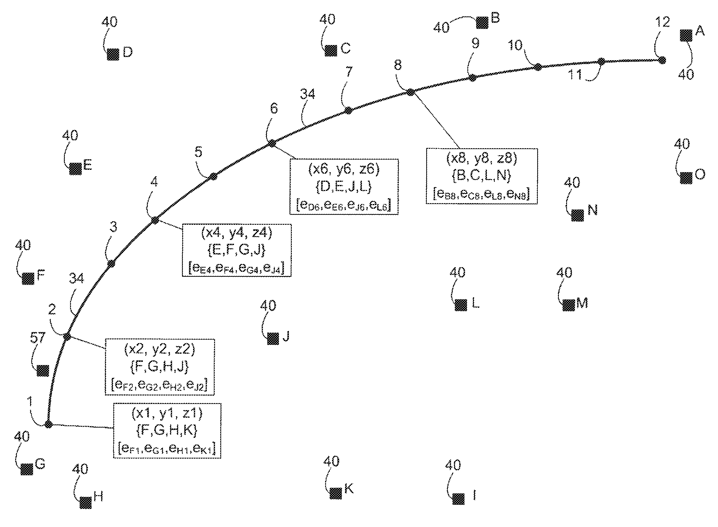
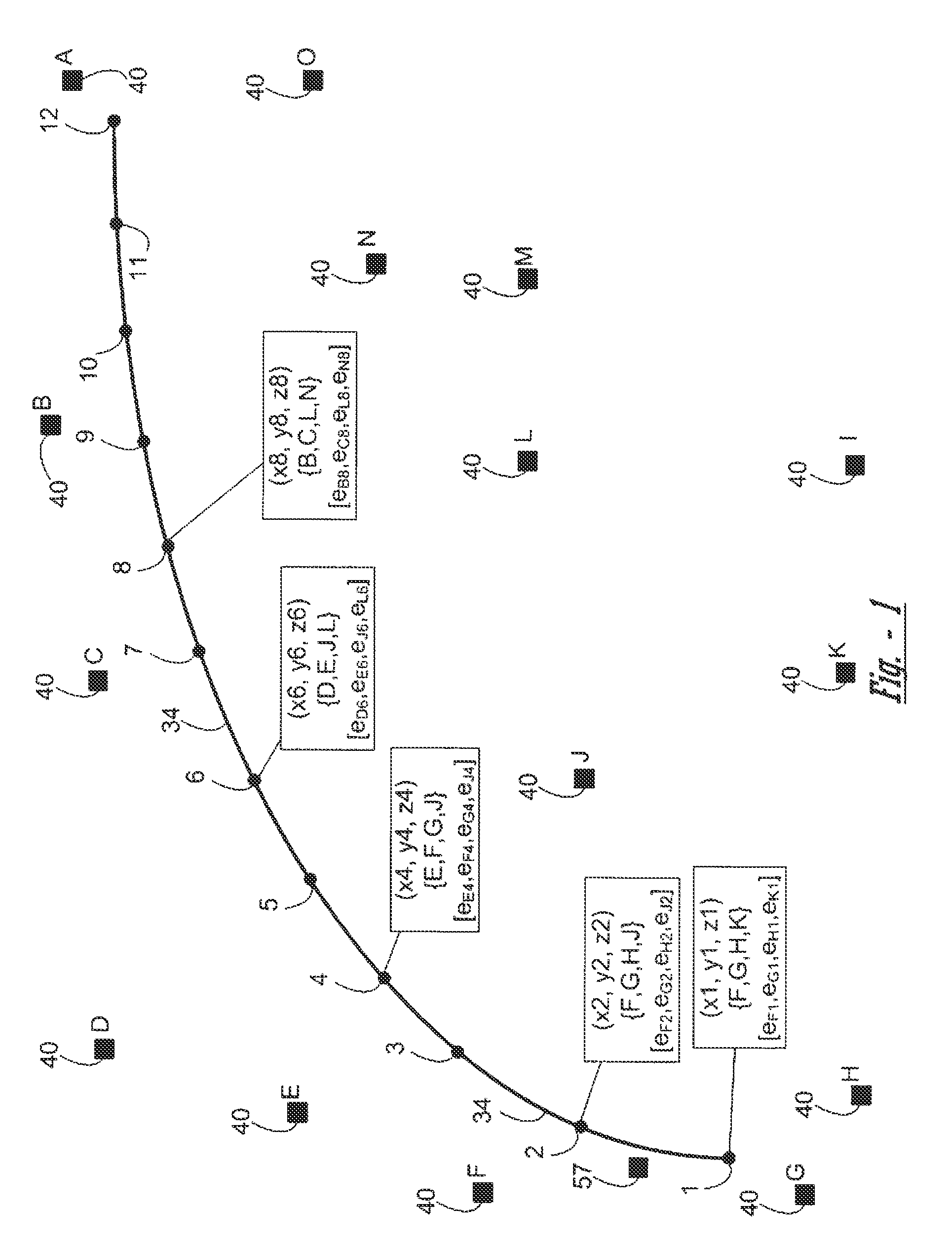
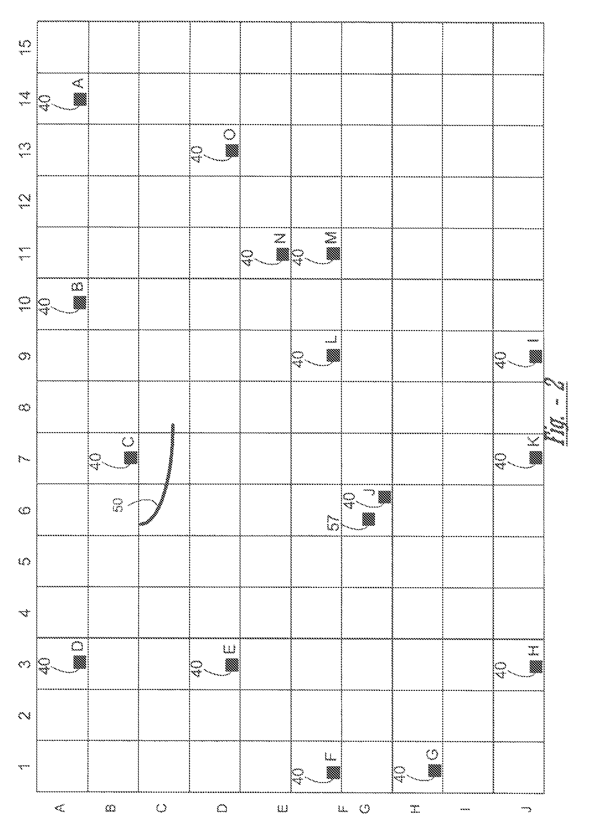
[0020]The present invention is predicated upon the provision of control and determining location of autonomous vehicles (AVs), particularly locating and controlling the path planning and guidance of autonomously guided vehicle (AGVs or target) in an area of space. The AGV may typical traverse a path based upon a trajectory. The trajectory is typically described by a series of waypoints that are located within a reference frame. For example, the trajectory may be a series of waypoints that are indicated by coordinates (e.g., 1-dimensional, 2-dimensional (2-D) or 3-dimensional (3-D)) in a coordinate system that has been set up for a global or local reference frame such as a map, a space, a plane, a terrain, a city block or the like. The waypoints, if desired, can include a time stamp for velocity reference for the path following control scheme.

[0021]The location or position and / or the heading of the AGV can be determined using a plurality of beacons (or base stations) examples of illu...


PUM


Description

[0001]The present application claims the benefit of the filing date of U.S. Provisional application Ser. No. 60 / 990,419 filed Nov. 27, 2008, which is herein incorporated by reference for all purposes.FIELD OF THE INVENTION[0002]The present invention relates to locating autonomous vehicles, or targets and methods for performing such location.BACKGROUND OF THE INVENTION[0003]The Global Positioning System (GPS) is based on the fixed location base stations and the measurement of time-of-flight of accurately synchronized station signature transmissions. The base stations for the GPS are geo-stationary satellites and require atomic clocks for synchronization.[0004]GPS has several draw backs including relatively weak signals that do not penetrate heavy ground cover and / or man made structures. Furthermore, the weak signals require a sensitive receiver. GPS also utilizes a single or narrow band of frequencies that are relatively easy to block or otherwise jam. The accuracy of the GPS system ...

Claims


Application Information

Patent Timeline
IPC IPC(8): G05D1/12G05B13/04G01C21/04G01S19/25
CPCG05D1/0212G01S5/14G01S5/0278G05D1/0276
Inventor SMID, EDZKOSTIGLICH, TOM
Owner HAILO TECH LLC
Why Eureka
Try Eureka