Method and System for Detecting and Mapping Hydrocarbon Reservoirs Using Electromagnetic Fields

a hydrocarbon reservoir and electromagnetic field technology, applied in the field of electromagnetic field detection and mapping of hydrocarbon reservoirs, can solve the problems of limiting the detection accuracy of deep resistivity targets, the noise floor of the transmitter/receiver system, and the quality of transmitter waveform stability and navigation, so as to achieve high-precision electric field gradients

Active Publication Date: 2010-09-30
RGT UNIV OF CALIFORNIA
View PDF28 Cites 16 Cited by
  • Summary
  • Abstract
  • Description
  • Claims
  • Application Information

AI Technical Summary

Problems solved by technology

Seismic methods had traditionally been used for detection of such geologic formations, however, the results could be ambiguous.
For example, certain structures such as sediments buried under salt, basalt or carbonate have poor seismic performance and productivity.
These structures generate strong reflections and reverberations, making imaging of the buried sediments difficult using acoustic methods alone.
Although the physics of diffusive EM propagation will always require that the target size be significant compared to the depth of burial, currently the noise floor of the transmitter / receiver system, along with the quality of transmitter waveform stability and navigation, are limiting factors in detecting deep resistivity targets.

Method used


Image

  • Method and System for Detecting and Mapping Hydrocarbon Reservoirs Using Electromagnetic Fields
  • Method and System for Detecting and Mapping Hydrocarbon Reservoirs Using Electromagnetic Fields
  • Method and System for Detecting and Mapping Hydrocarbon Reservoirs Using Electromagnetic Fields

Examples


Embodiment Construction

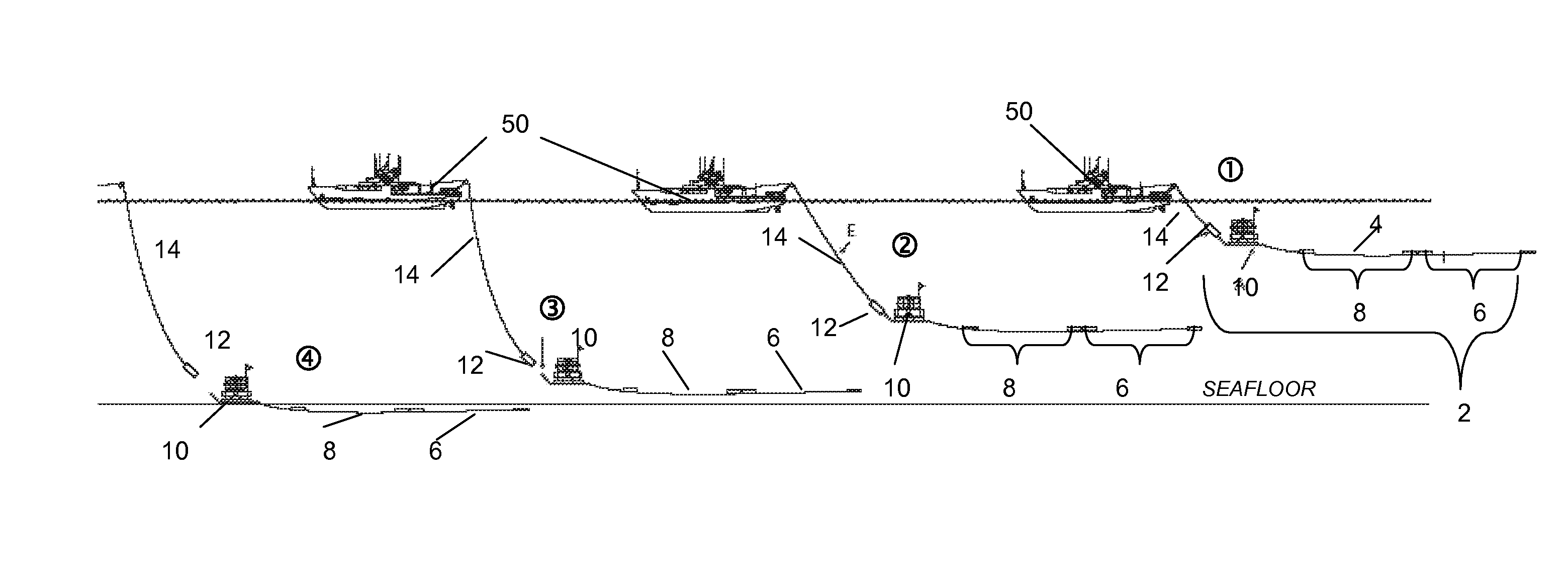
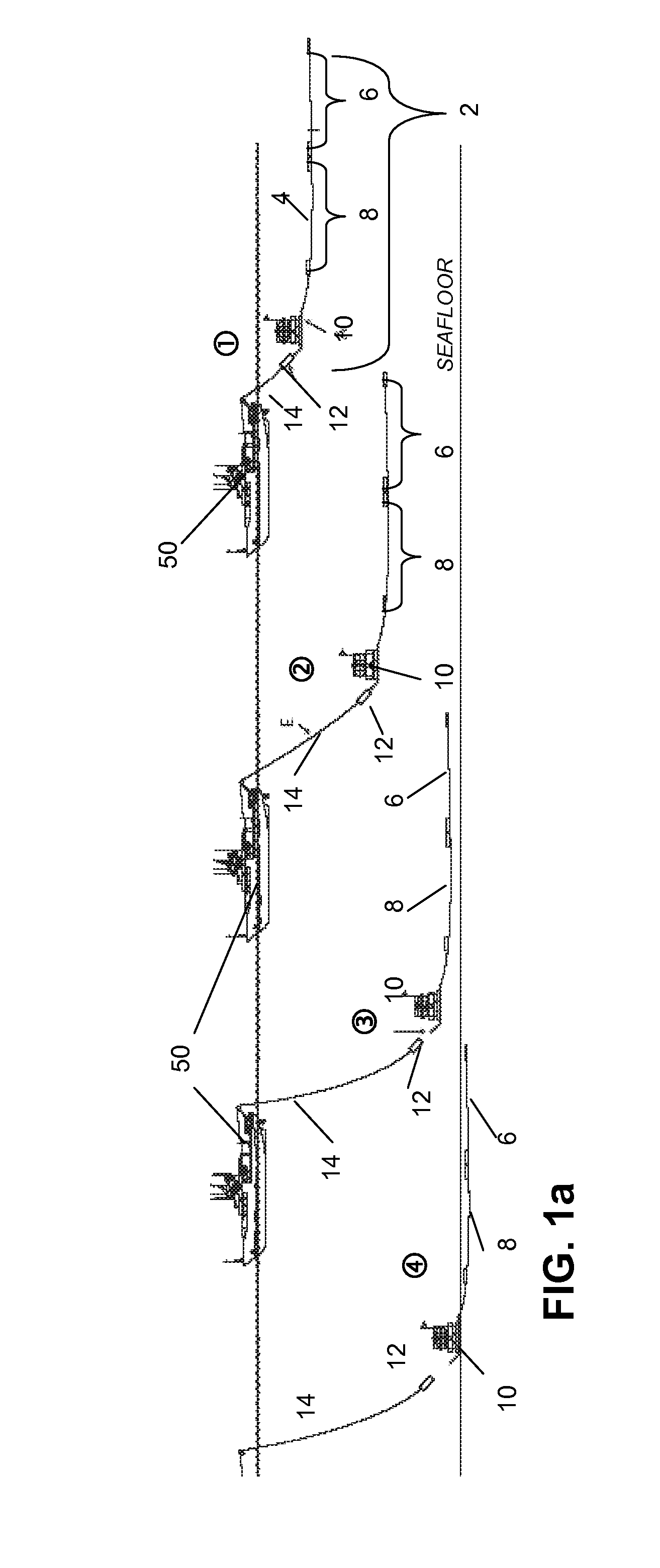
[0024]The present invention extends the capability of marine controlled source EM (CSEM) technology to permit detection of ultra-deep targets (lacking seismic direct hydrocarbon indicators, or DHI's) by improving detection thresholds. Long receiver antennas (LEM instruments) are used to determine the spatial gradient of the horizontal electric fields. An additional aspect of the invention incorporates triangulation techniques using a transmitter mounted long base line (LBL) acoustic system for more accurate source navigation.

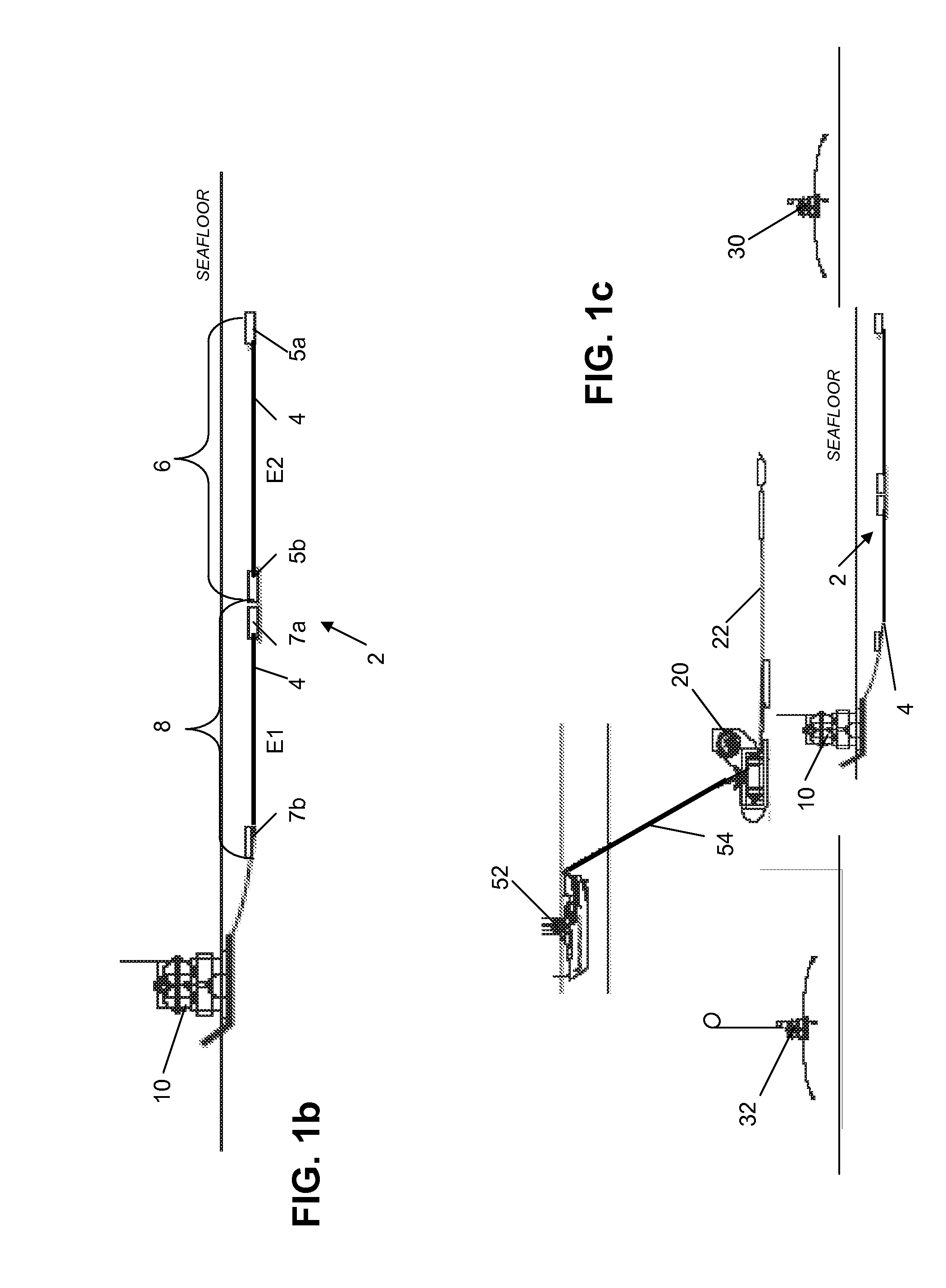
[0025]The present invention improves detection thresholds by using long receiver antennas (LEM instruments). With the exception of the magnetotelluric signal, most of the noise sources in the seafloor CSEM receivers are voltage sources, rather than electric field noise. For this reason, improved SNR can be achieved by making the electric field sensor antenna longer. Seafloor recorders with antennae up to 1 km long can be deployed using only one ship. (See, e.g.,...


PUM


Abstract

The system and method provided modify a conventional seafloor long-wire electromagnetic (LEM) receiver by increasing the number of discrete antennae placed on the long wire. Two dipoles of electric field data are positioned exactly adjacent to each other, providing input to the same data logger system located within a seafloor survey unit to which the long wire is connected. Highly precise electric field gradients can be obtained by taking the difference of the measurements of the two electrodes, both for amplitude and phase. Any common-mode source of noise, such as magnetotelluric signals and receiver instrument noise will be rejected when the signals from the two electrodes are differenced. An acoustic navigation system utilizes a plurality of transponders to permit triangulation for accurate source-receiver ranging.

Description

RELATED APPLICATIONS[0001]This application claims the benefit of the priority of U.S. provisional application No. 60 / 824,051, filed Aug. 30, 2006, which is incorporated herein by reference in its entirety.FIELD OF THE INVENTION[0002]The invention relates to a method and system for detection and mapping of geologic formations such as seafloor hydrocarbon reservoirs by measuring electromagnetic fields and more particularly to measuring of the electric and / or magnetic field amplitude gradient and phase velocity on the seafloor during controlled source marine electromagnetic surveys.BACKGROUND OF THE INVENTION[0003]In geophysics, electric and electromagnetic (EM) methods are used to measure the electric properties of geologic formations. At low frequencies, rock resistivity accounts for almost all of the electromagnetic response. Because replacement of saline pore fluids by hydrocarbons increases the resistivity of reservoir rocks, EM methods are important exploration tools. Seismic met...

Claims


Application Information

Patent Timeline
Patent Type & Authority Applications(United States)
IPC IPC(8): G06F19/00G01V3/12
CPCG01V3/12G01V3/083G01V1/3835
Inventor CONSTABLE, STEVEN C.KEY, KERRY W.
Owner RGT UNIV OF CALIFORNIA
Why Eureka
Try Eureka