System for determining a height coordinate

a technology of height coordinate and height information, which is applied in the direction of static indicating devices, navigation instruments, instruments, etc., can solve the problems of inability to accurately identify the triangular face, inability to consistently display the map feature for the various different levels or resolutions, and inability to store one height coordinate for each level in terms of storage space, etc., to achieve low computational cost, reduce computational complexity, and increase performance

Active Publication Date: 2012-11-01
HARMAN BECKER AUTOMOTIVE SYST
View PDF1 Cites 8 Cited by
  • Summary
  • Abstract
  • Description
  • Claims
  • Application Information

AI Technical Summary

Benefits of technology

[0011]Accordingly, there is a need for a navigation system and for methods which allow performance to be increased when determining the height coordinate of a map feature based on its lateral coordinates. According to an example, a navigation system is provided. The navigation system has a database and a processing device coupled to the database. The database stores, for a plurality of tiles of a tiling, respectively index data for the respective tile and at least one triangulated irregular network, TIN, defining a three-dimensional surface. The index data includes for each one of plural cells of a grid respectively an identifier for each triangular face which at least partially overlaps with the respective cell. The plural cells of the grid are defined so as to cover the respective tile. The processing device is configured to determine a height coordinate of a map feature located on the three-dimensional surface based on lateral coordinates of the map feature. To this end, the processing device is configured to use the index data to determine a triangular face of the at least one TIN on which the map feature is located, in order to determine the height coordinate.
[0012]The database has an index structure. Using the index data, a small subset of triangular faces on which the map feature can potentially be located may be determined at low computational costs. Thereby, the computational complexity required to determine the height coordinate at run time may be reduced. According to conventional terminology in the art, “lateral coordinates” refer to the coordinates measured in orthogonal directions normal to the gravity vector. As used herein, a three-dimensional triangular face may be considered to “overlap” with a cell if the projection of the triangular face onto the tile overlaps with the cell. I.e., the height information of the triangular face may be disregarded when determining whether a triangular face overlaps with a cell. The cells may be rectangular cells, having sides aligned with the x- and y-coordinate axes of the reference frame in which the lateral coordinates of the map feature are defined.

Problems solved by technology

If only one height coordinate is stored for a map feature, the map feature may not be consistently displayed for the various different levels or resolutions which are typically available for displaying terrain, owing to the differences in the underlying digital elevation model (DEM) from one level to another level.
Storing one height coordinate for each level is undesirable in terms of storage space.
However, it may be computationally costly to identify the correct triangular face, in particular for tiles which include a large number of triangular faces.

Method used


Image

  • System for determining a height coordinate
  • System for determining a height coordinate
  • System for determining a height coordinate

Examples


Embodiment Construction

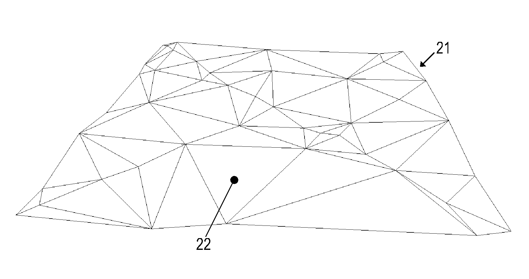
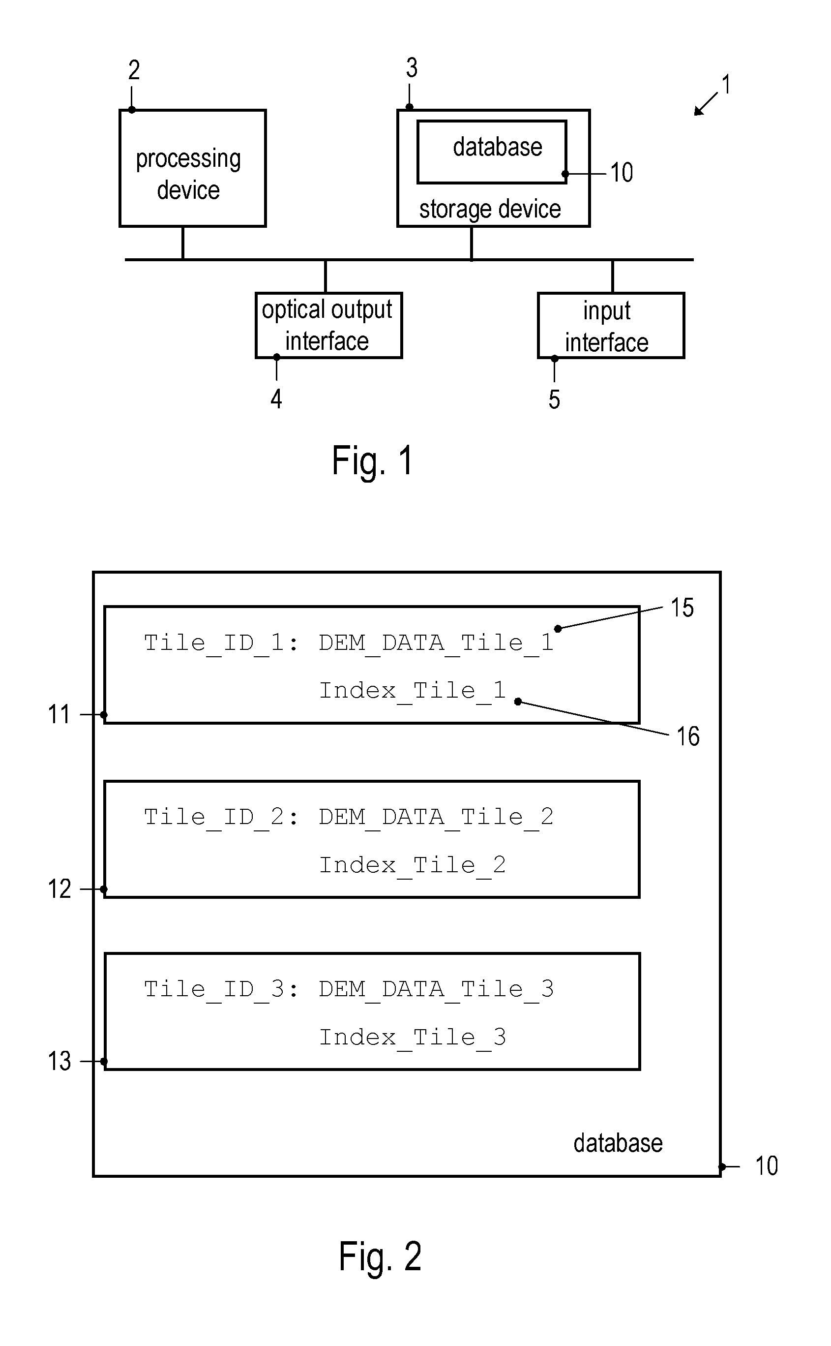
[0036]FIG. 1 schematically illustrates a navigation system 1 according to an example. The navigation system 1 comprises a processing device 2 controlling the operation of the navigation system 1. The processing device 2 may comprise a central processing unit, for example in form of one or more microprocessors, digital signal processors or application-specific integrated circuits. The processing device 2 may also include a graphics processor. The navigation system 1 further includes a database 10 stored in a storage device 3. The storage device 3 may comprise any one, or any combination, of various types of memory, such as random access memory, flash memory or a hard drive, but also removable memories such as a compact disk (CD), a DVD, a memory card or the like. The navigation system 1 also includes an optical output unit 4. The navigation system 1 may include additional components, such as a position sensor and / or a wireless receiver and / or an input interface 5.

[0037]The storage de...


PUM


Abstract

A navigation system has a database which stores index data for, respectively, a tile of a tiling. The index data includes, for each one of plural cells of a grid which is superimposed on the tile, respectively an identifier for each triangular face of a triangulated irregular network which at least partially overlaps with the respective cell. The plural cells of the grid are defined so as to cover the respective tile. A processing device of the navigation system is configured to use the index data to determine a triangular face on which a map feature having given lateral coordinates is located, in order to determine a height coordinate of the map feature.

Description

BACKGROUND OF THE INVENTION[0001]1. Priority Claim[0002]This application claims the benefit of priority from European Patent Application EP 11 164 314.4, filed Apr. 29, 2011, which is incorporated by reference[0003]2. Technical Field[0004]This disclosure generally relates to methods and devices associated with the use of height information in navigation systems. Examples of the invention relate in particular to a navigation system, a method of determining a height coordinate and a method of generating a database. Examples of the invention relate in particular to such devices and methods which may be used for visualizing a three-dimensional terrain, including map features positioned on the terrain.[0005]3. Related Art[0006]Height information for a terrain may be used in navigation systems. One exemplary field in which such height information may be used is the outputting of three-dimensional maps. Optical output units may be used for outputting electronic maps. Since electronic maps ...

Claims


Application Information

Patent Timeline
Patent Type & Authority Applications(United States)
IPC IPC(8): G09G5/00G06T15/00
CPCG01C21/32G06F17/30241G06F17/30321G06T17/20G06T17/05G06F16/2228G06F16/29G01C21/3867G01C21/3881G01C21/387G01C21/3874
Inventor IVANOV, VLADIMIRFELDBAUER, THOMASPRYAKHIN, ALEXEYKUNATH, PETERSTRASSENBURG-KLECIAK, MAREK
Owner HARMAN BECKER AUTOMOTIVE SYST
Why Eureka
Try Eureka