Radio positioning of a mobile receiver using a virtual positioning reference

a mobile receiver and virtual positioning technology, applied in the direction of navigation instruments, distance measurement, instruments, etc., can solve the problems of inability to calculate the transmitter clock offset a and local clock error c values, and the opportunistic terrestrial radio signal transmitters that are available to the positioning system are not usually synchronized, so as to reduce the complexity of the guidance system, improve localization, and reduce the effect of physical circuitry

Active Publication Date: 2016-04-21
BAE SYSTEMS PLC
View PDF20 Cites 11 Cited by
  • Summary
  • Abstract
  • Description
  • Claims
  • Application Information

AI Technical Summary

Benefits of technology

[0038]The same differential positioning module can be used in conjunction with both virtual positioning references and real reference base stations that are intended for navigation. This can be useful because the autonomous vehicle may be able to receive information from a real reference base station and use this information to localize and/or improve localization. In doing so, the calculations necessary can be performed through the same differential positioning module, reducing the complexity of the guidance system in the autonomous vehicle. In practice, if the differential calculation module is implemented in hardware, the reduced physical circuitry (“silicon real estate”) can increase the portability of the guidance system. Potentially, this may also reduce the computational burden on a general purpose processor of the guidance system.
[0039]Embodiments of the present invention can be used in combination with current systems that require a real reference receiver, so that the present invention serves to bridge any gaps caused by communication dropout in reception of the “real” reference signal. The autonomous vehicle, on losing contact with the reference receiver, can then generate the required reference positioning measurements from the real reference and carry on in the meantime using signals from transmitters of opportunity while employing the same positioning algorithms, filters, and processes, until communication with the real reference is reestablished. This approach will tend to provide the highest level of positioning accuracy if the communications drop outs are short enough such that the transmitter clocks of the opportunistic transmitters remain sufficiently stable during the communication drop-out period.
[0040]Embodiments of the present invention comprise establishing a plurality of v

Problems solved by technology

However, opportunistic terrestrial radio signal transmitters that are available to a positioning system are not usually synchronized—even if they are set up to transmit the same radio signal type, with the same code word repeat rate.
As can be observed from a navigation system such a GPS, synchronization between the radio signal sources is very useful for radio localization—but is often not possible in an environment in which opportunistic, unsynchronized terrestrial radio signals are the only radio signal sources available for localization.
However, the calculation of the transmitter clock offset a and local clock error c values can be computationally expensive, especially when considering that multiple transmitters are required for effective self-localization.
Furthermore, if a vehicle employs a relatively cheap and simple navigation device, the local onboard clock is not likely to be stable.
Therefore, the calcul

Method used


Image

  • Radio positioning of a mobile receiver using a virtual positioning reference
  • Radio positioning of a mobile receiver using a virtual positioning reference
  • Radio positioning of a mobile receiver using a virtual positioning reference

Examples


Embodiment Construction

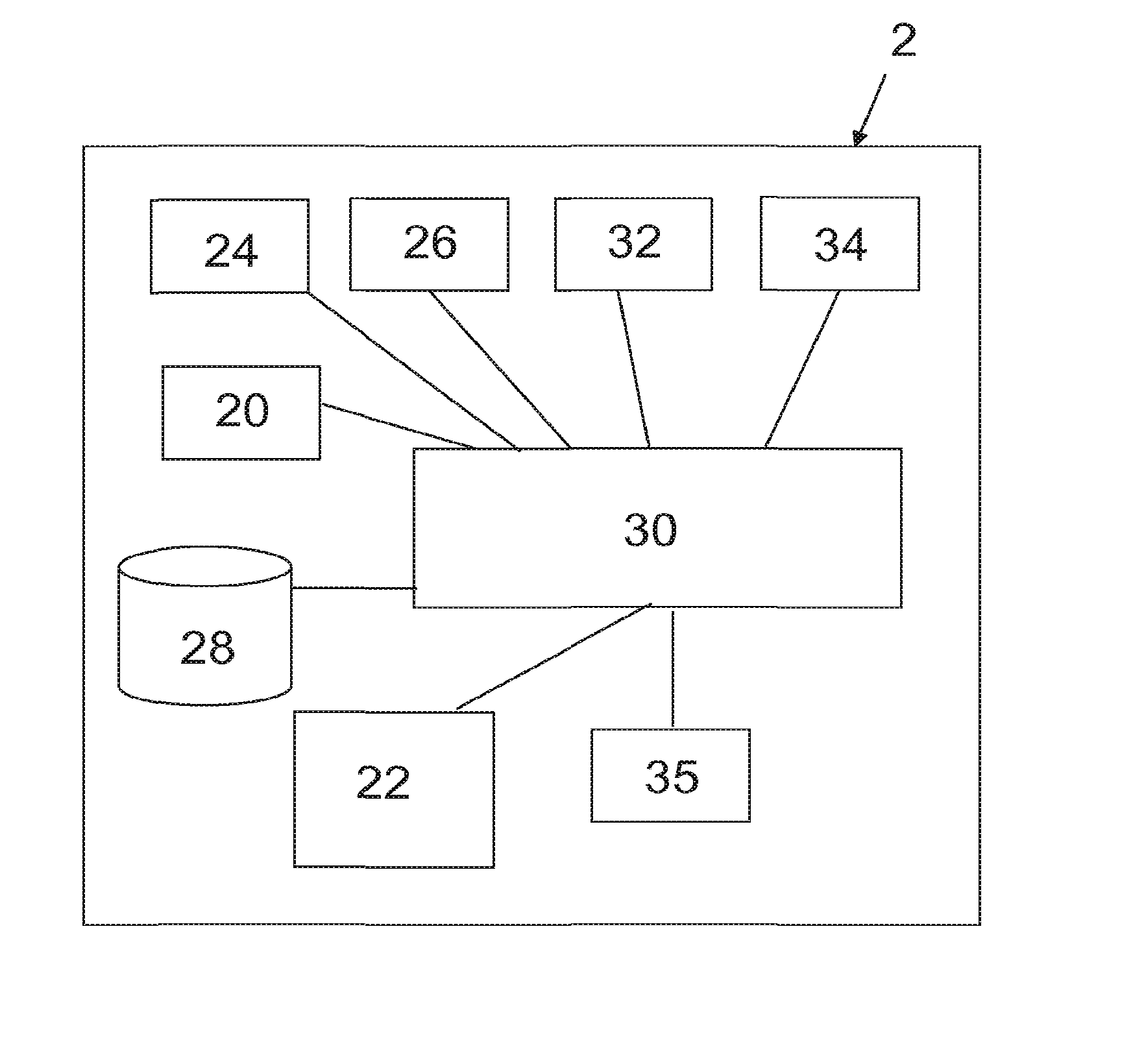
[0103]Referring to FIG. 1 there is schematically shown a guidance system for an autonomous vehicle 2 according to a first embodiment of the present invention. The guidance system includes a primary positioning resource in the form of a GPS receiver 20, a terrestrial radio signal receiver 22, an Inertial Measurement Unit (IMU) 24, an interface module 26, a database 28, a general purpose processor 30, a user interface module 32, a vehicle control module 34 and a secondary processor 35 in the form of a differential positioning module dedicated to performing differential timing and distance calculations. The autonomous vehicle 2 is also equipped with a clock incorporated as part of the processor 30.

[0104]The GPS receiver 20 and terrestrial receiver 22 collect data from respective GPS and terrestrial radio signals as is known in the art, and send their data to the processor 30. The processor 30 also receives data from the IMU 24, and optionally, the interface module 26. The interface mod...


PUM


Abstract

Methods and systems are disclosed for radio positioning of a vehicle using a virtual positioning reference established by logging a known position of the vehicle together with a local time that a first instance of a predictably repeated code word is received from an opportunistic terrestrial radio transmitter. During movement of the vehicle to a second, unknown position, a local clock is used to determine the time difference between when the virtual positioning reference is predicted to receive a second instance of the code word and when the vehicle actually receives the second instance of the code word, thereby providing positioning information when traditional navigation signals such as GPS are not available. The radio positioning information is then used to initiate an action such as recording the location information for future retrieval by a user, and/or controlling the movements of an autonomous vehicle.

Description

RELATED APPLICATIONS[0001]This application is a continuation in part of U.S. application Ser. No. 13 / 500,016, which is herein incorporated by reference in its entirety for all purposes. U.S. application Ser. No. 13 / 500,016 is a national phase application filed under 35 USC §371 of PCT Application No. PCT / GB2010 / 051654 with an International filing date of Oct. 4, 2010. PCT Application No. PCT / GB2010 / 051654 claims priority of the following: GB Patent Application 0917388.1 filed Oct. 5, 2009, EP Patent Application 09275092.6 filed Oct. 5, 2009, GB Patent Application 0917384.0 filed Oct. 5, 2009, EP Patent Application 09275091.8 filed Oct. 5, 2009, GB Patent Application 0920772.1 filed Nov. 27, 2009, EP Patent Application 09177349.9 filed Nov. 27, 2009, GB Patent Application 1009486.0 filed Jun. 7, 2010, EP Patent Application 10275059.3 filed Jun. 7, 2010, and GB Patent Application 1013413.8 filed Aug. 10, 2010. Each of these applications is herein incorporated by reference in their ent...

Claims


Application Information

Patent Timeline
IPC IPC(8): G01S5/02G01C21/34G01S19/07G05D1/00
CPCG01S5/0263G01S19/07G01C21/34G05D1/0088G05D1/0278G05D1/0285G05D2201/0213G01S5/021G01C21/20G01S19/48
Inventor FARAGHER, RAMSEY MICHAEL
Owner BAE SYSTEMS PLC
Why Eureka
Try Eureka