Intelligent passive navigation system for back-up and verification of GPS

a passive navigation and intelligent technology, applied in direction finders using radio waves, navigation instruments, instruments, etc., can solve the problems of system having the ability to selectively use signals from a large number of diverse ground based emitters, easy to jam, and easy to be subject to system outages, etc., to reduce biases, improve positioning accuracy, and reduce biases

Inactive Publication Date: 2005-07-12
INFORMATION SYST LAB
View PDF15 Cites 15 Cited by
  • Summary
  • Abstract
  • Description
  • Claims
  • Application Information

AI Technical Summary

Benefits of technology

[0015]Once the DOA and emitter geolocation for one or more received signals has been determined, the computer can then input this information into a triangulation-type algorithm to estimate a geolocation of the airborne platform. If desired, the initial geolocation estimate can be further refined by the system. More specifically, the initial geolocation estimate can be used to identify other emitters in the vicinity of the initial geolocation estimate that can be used to further refine the initial geolocation estimate. The receiver is then configured to scan the frequency bands corresponding to the newly identified emitters. In one implementation, additional emitters are identified to improve positioning accuracy by minimizing the geometric dilution of precision (GDOP) that can occur when the selected emitters are unfavorably grouped, such as when the selected emitters are all located in one place or along one line, Also, the additional emitters can be used to reduce biases caused by multipath propagation of the emitter signals.
[0016]In one implementation of the system, the effect of terrain scattering on emitter signals can be used to select the most appropriate emitters. For example, terrain scattering information can be used to select emitters having desirable RF characteristics such as the strongest signal power or the lowest levels of multipath propagation. In addition, the terrain scattering information can be used to reduce biases that are caused by multipath propagation of the emitter signals.

Problems solved by technology

Nevertheless, despite these beneficial aspects, GPS is susceptible to system outages, and is subject to jamming and spoofing.
First, but not necessarily the most important reason, is cost.
In addition to the intrinsic costs savings described above, a system having the ability to selectively use signals from a large number of diverse ground based emitters is relatively hard to jam.
In addition, a system having the ability to selectively use signals from a large number of geographically distributed ground based emitters is not easily rendered inoperable by a localized power outage.

Method used


Image

  • Intelligent passive navigation system for back-up and verification of GPS
  • Intelligent passive navigation system for back-up and verification of GPS
  • Intelligent passive navigation system for back-up and verification of GPS

Examples


Embodiment Construction

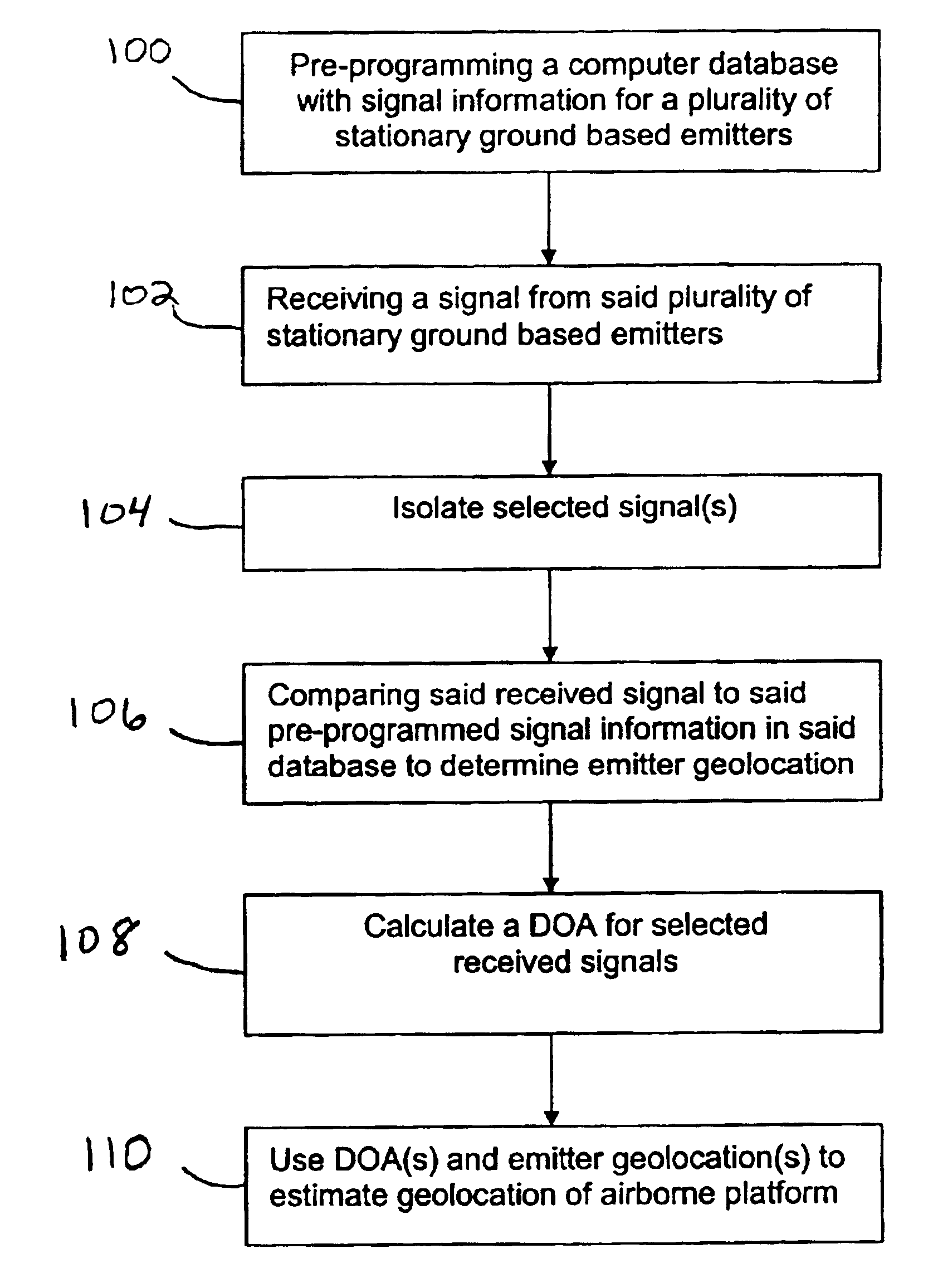
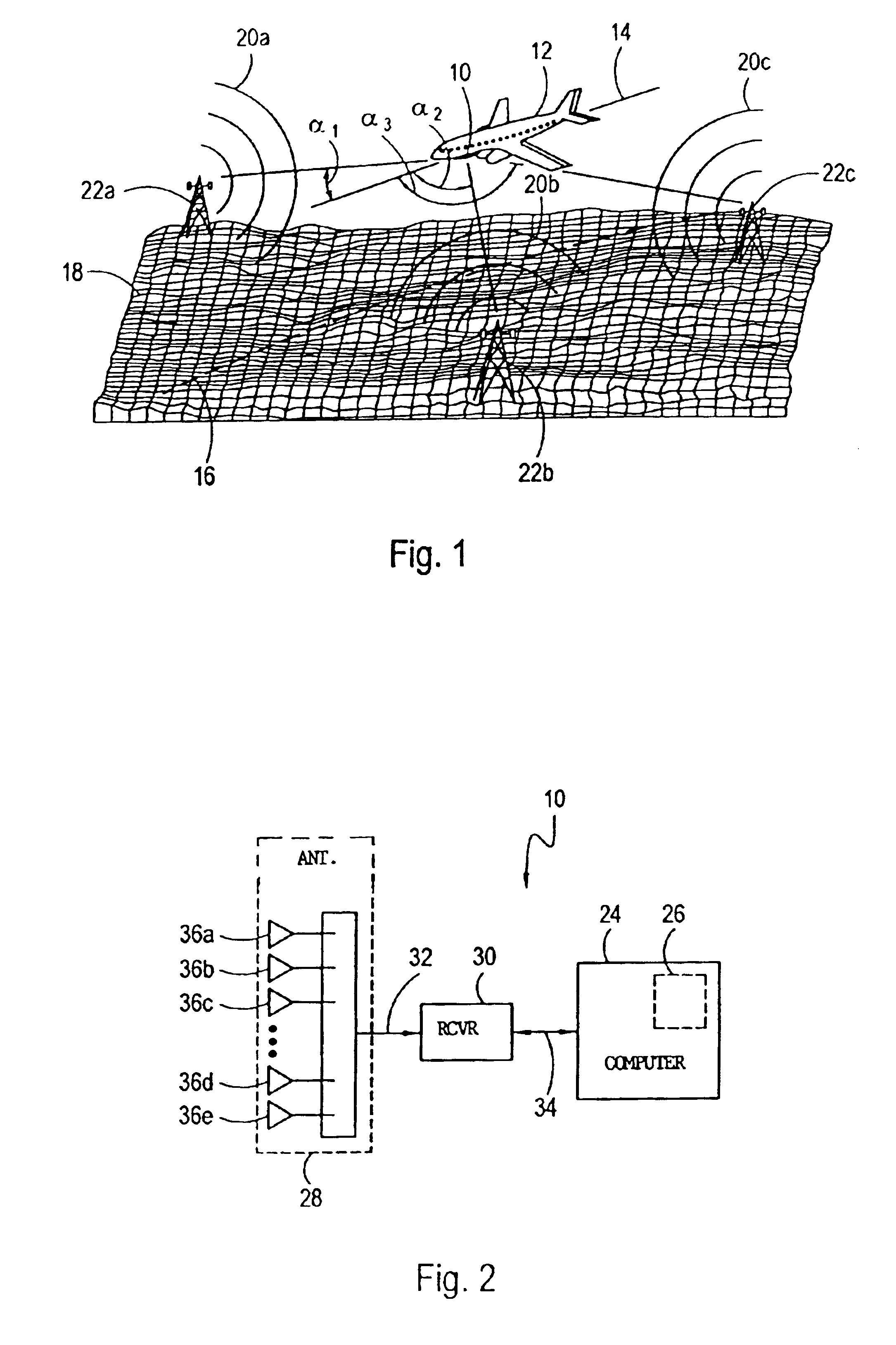
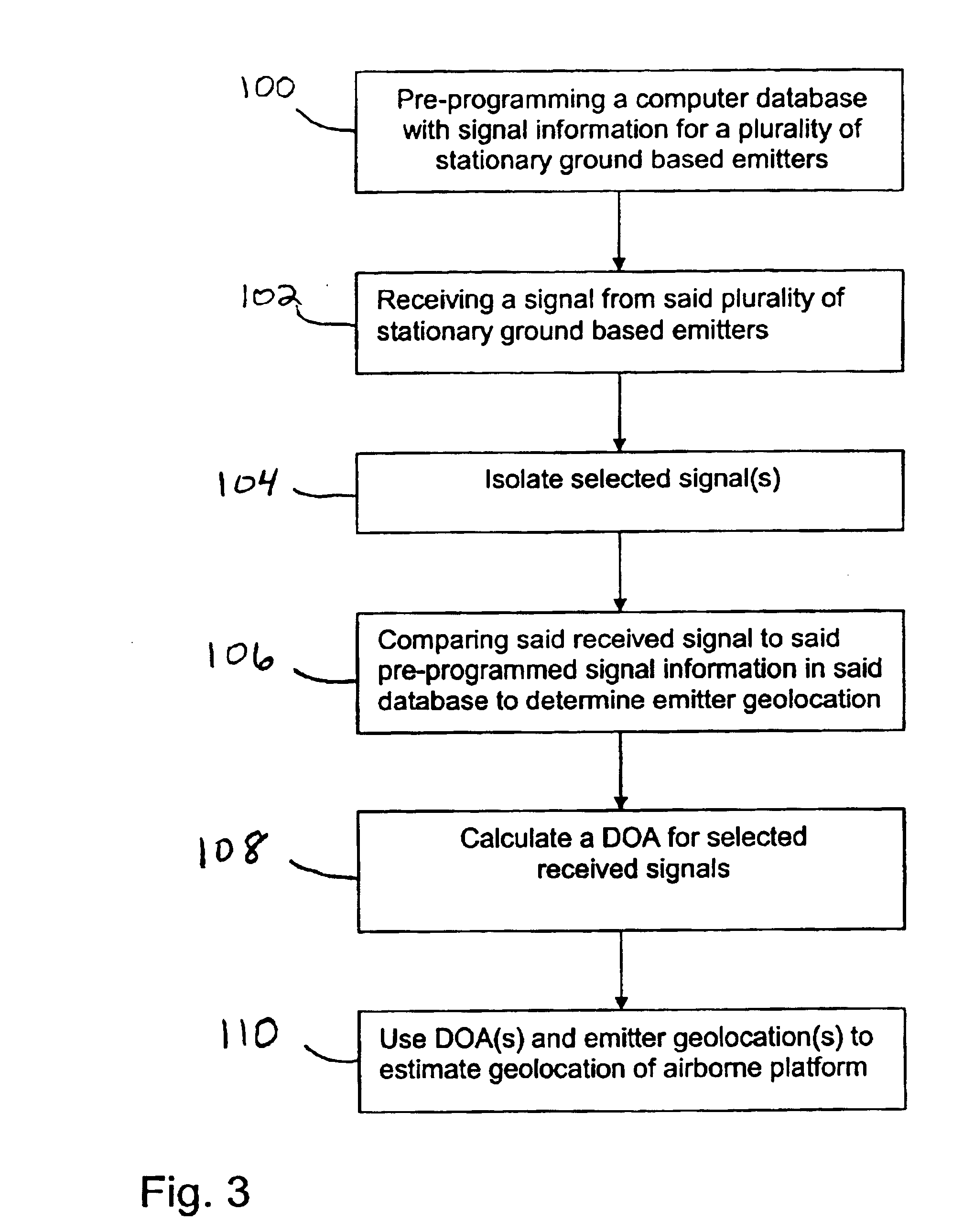
[0022]Referring initially to FIG. 1, an intelligent passive navigation system (hereinafter system 10) for determining the geolocation (e.g. latitude, longitude and altitude) of an airborne platform 12 on a flight path 14 is shown. For clarity, a projection 16 of the flight path 14 onto the surface of the earth 18 is also shown. As intended for the system 10, the geolocation of the airborne platform 12 can be initially estimated and subsequently updated as the airborne platform 12 moves to allow the airborne platform 12 to be navigated along a desired course of flight. With the description provided below, those skilled in the pertinent art will appreciate that the system 10 can be used alone as a primary navigation system for an airborne platform 12 or as a secondary navigation system to back-up and verify a primary navigation system, which can be a GPS navigation system or a primary navigation system based on some other technology.

[0023]In operational overview as shown in FIG. 1, th...


PUM


Abstract

A passive navigation system for an airborne platform includes an on-board computer having a database that contains preprogrammed information regarding pre-existing ground-based signal emitters (e.g. cell-phone, television and radio broadcast transmitters). For each emitter, the database includes the geolocation of the emitter and identifying signal characteristic(s) of each emitter's signal such as frequency, bandwidth and strength. An antenna array and digital receiver cooperate with the computer on the platform to passively receive signals from the emitters and determine a direction of arrival (DOA) for selected signals. The computer also extracts identifying signal characteristic(s) from selected received signals and matches them against the database information to ascertain the geolocation of the emitter that corresponds to the received signal. The platform location is then calculated from the DOA(s) and emitter geolocations using a triangulation-type algorithm. Also, preprogrammed site-specific terrain scattering information can be compared to observed scattered signals to enhance system accuracy.

Description

[0001]This application is a continuation-in-part of application Ser. No. 09 / 895,613 filed Jun. 29, 2001 now U.S. Pat. No. 6,593,875. The contents of application Ser. No. 09 / 895,613 are incorporated herein by reference.FIELD OF THE INVENTION[0002]The present invention pertains generally to navigation systems for airborne platforms such as aircraft. More particularly, the present invention pertains to passive navigation systems that can be used to navigate an airborne platform over a relatively long route of flight. The present invention is particularly, but not exclusively, useful as a secondary passive navigation system that can be used to back-up and verify a primary GPS navigational system.BACKGROUND OF THE INVENTION[0003]GPS (i.e. a Global Positioning System) is a satellite-based radio navigation, positioning and time transfer system that provides highly accurate navigational information on a continuous global basis to an unlimited number of properly-equipped users. Important asp...

Claims


Application Information

Patent Timeline
Patent Type & Authority Patents(United States)
IPC IPC(8): G01S1/00G01S13/00G01S13/60G01S13/522G01S13/87G01S13/06G01S13/86G01S7/02G01S7/41
CPCG01S7/412G01S13/06G01S13/522G01S13/60G01S13/86G01S13/87G01S19/15G01S19/23G01S19/48
Inventor BERGIN, JAMESONHALSEY, J. DOSSCARLOS, JOHN DON
Owner INFORMATION SYST LAB
Why Eureka
Try Eureka