Method and device for tracking weak global navigation satellite system (GNSS) signals

a global navigation satellite and signal technology, applied in the direction of measuring devices, instruments, masers, etc., can solve the problems of weak global navigation satellite system (gnss) signal strength, weak positioning accuracy, and breakdown of tracking loops inside regular receivers

Inactive Publication Date: 2009-12-29
CSR TECH HLDG
View PDF17 Cites 33 Cited by
  • Summary
  • Abstract
  • Description
  • Claims
  • Application Information

AI Technical Summary

Problems solved by technology

However, when the line-of-sight view between the receiver and a satellite is obstructed (e.g., due to foliage, mountains, buildings, or other structures) the GPS signal strength may be severely attenuated, leading to position fix with poor accuracy and even breakdown of tracking loops inside a regular receiver.
Due to the discrete nature of the acquisition search, it can only provide coarse estimates of signal parameters as the starting point to close a refined “search” loop in the tracking stage.
However, when the coherent integration interval extends beyond, e.g., 20 milliseconds, which is the duration of one data bit for GPS C / A-codes, the sign reversal of navigation data bits becomes destructive if it occurs in the middle of a long coherent integration.
A brute force approach considering all possible combinations is undesired because it would require excess computation time, storage memory, and power consumption.
This approach, however, comes with a heavy price associated with installing and maintaining the wireless aiding infrastructure and services required to provide the coverage.
However, such an approach is not cost-effective.
If used for tracking with fixed grid points in an open loop manner, it becomes inefficient in computation without incorporating any information that has been gathered about the signal during the acquisition and tracking process and, more importantly, its performance is relatively poor simply because of a rather large spacing between search steps.
However, its actual implementation must deal with such problems as unknown data bit transitions occurred within a long integration interval that is extended in order to boost the signal power.
In addition, the residual frequency error either due to the relative motion between a GPS satellite and the receiver and / or to the receiver's clock drifts becomes critical when the length of coherent integration interval is significant.
There are, consequently, outstanding problems with known techniques when applied to weak GPS signal tracking in a standalone high-sensitivity receiver.

Method used


Image

  • Method and device for tracking weak global navigation satellite system (GNSS) signals
  • Method and device for tracking weak global navigation satellite system (GNSS) signals
  • Method and device for tracking weak global navigation satellite system (GNSS) signals

Examples


Embodiment Construction

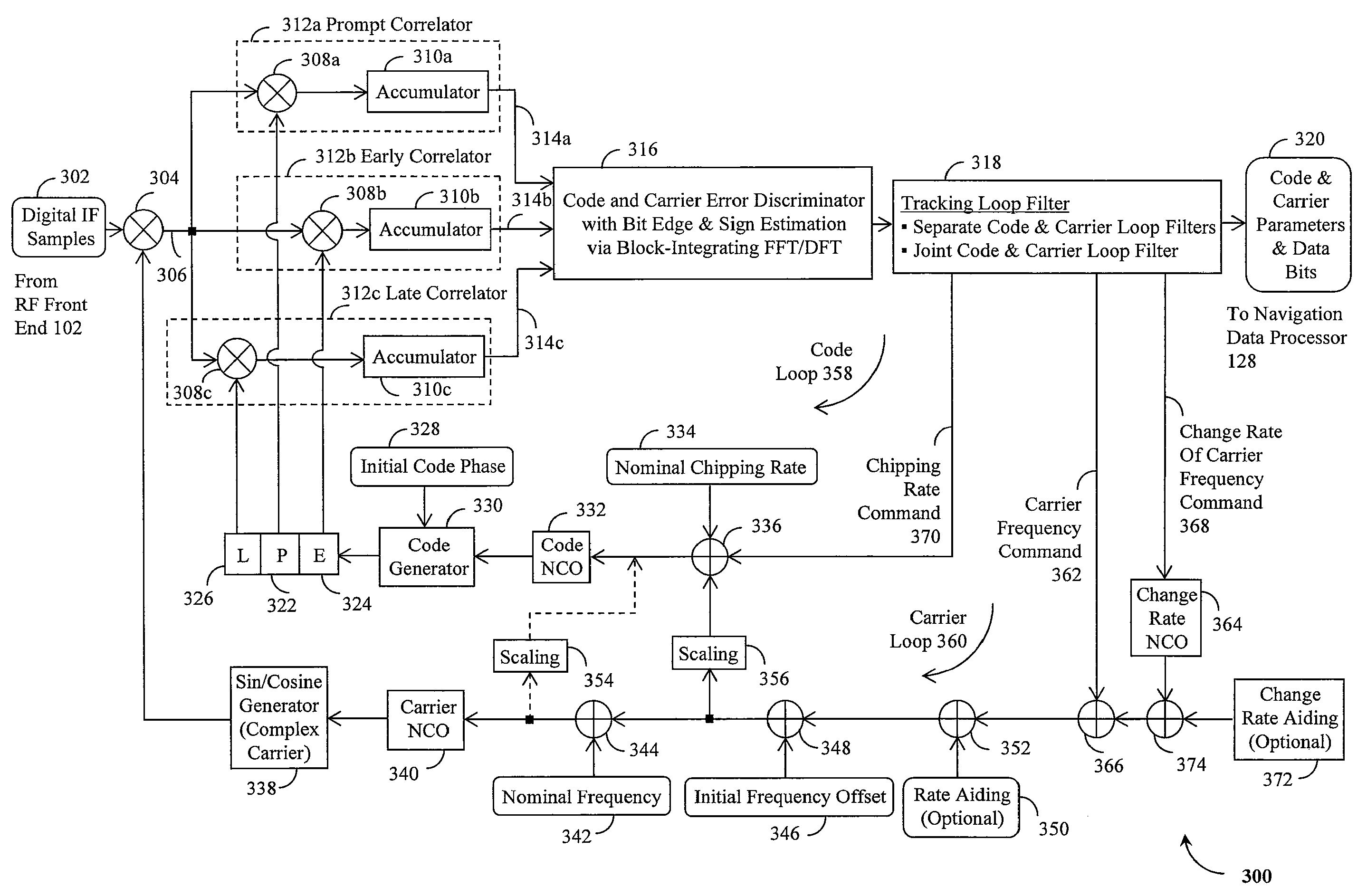
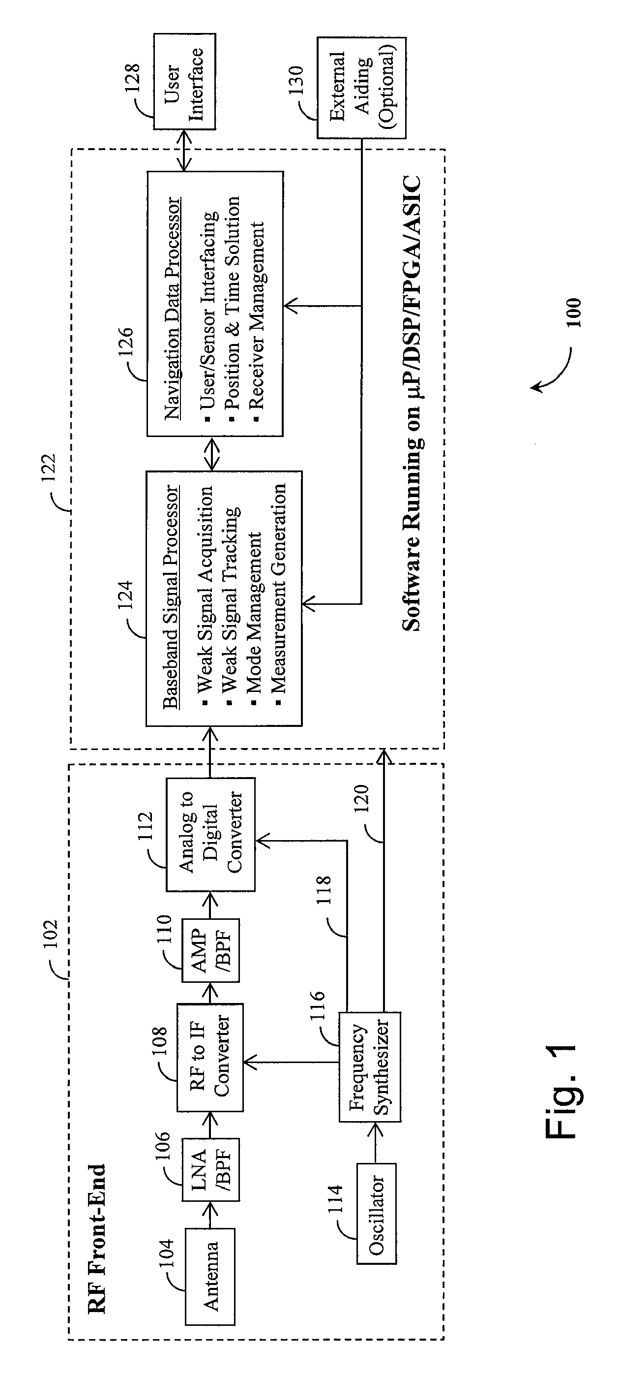
[0028]The present invention provides systems and methods for a GNSS receiver capable of tracking weak satellite signals and extracting time, frequency and other parameters from the signals as an integral part of the receiver's baseband signal processor operations. Although systems and methods of the present invention can be used for the tracking of various signals used in the GNSS, systems and methods of the present invention are particularly well suited for use with the tracking of signals from GPS satellites. Accordingly, although not so limited, an exemplary embodiment of the present invention will be described in an application of tracking weak signals from GPS satellites.

[0029]Referring to FIG. 1, an exemplary standalone high-sensitivity GPS receiver 100 is shown with its weak signal tracking capability implemented as an integral part of the receiver's baseband signal processor 124 software, which runs on a microprocessor (μP), a digital signal processor (DSP), a field programm...


PUM


Abstract

A Global Navigation Satellite System (GNSS) receiver and associated method capable of tracking weak GNSS signals from a plurality of GNSS satellites. In a preferred embodiment, code and carrier tracking loops are initially closed around the code phase, carrier frequency, and data bit edge estimates handed over from an acquisition mode. In subsequent tracking, early, prompt, and late copies of the code replica are correlated with the incoming signal. The prompt correlations are coherently integrated over an extended updating interval for data bit edge and sign estimation as well as for carrier phase and frequency error discrimination whereas the early and late correlations are used for code error discrimination. Code delay and carrier phase and frequency errors are used to update the code and carrier tracking loop filters. Together with data bits, they form observables of a GNSS signal's time and frequency parameters for timing and position fixing.

Description

RELATED APPLICATIONS[0001]This application is a continuation-in-part of U.S. patent application Ser. No. 11 / 173,894, entitled “Method and Device for Acquiring Global Navigation Satellite System (GNSS) Signals,” filed on Jul. 1, 2005.FIELD OF THE INVENTION[0002]The present invention relates generally to devices and methods for tracking radio signals. In particular, the present invention relates to direct sequence spread spectrum (DS / SS) signals such as those used in the Global Navigation Satellite System (GNSS).BACKGROUND OF THE INVENTION[0003]The Global Navigation Satellite System (GNSS) will encompass the U.S. Global Positioning System (GPS), the Russian Global Navigation Satellite System (GLONASS) and the future European GALILEO System as well as other regional satellite radio navigation systems and space borne and ground-based augmentation systems. Being fully operational, the GPS has a constellation of twenty four satellites that are in six different orbit plans around the earth...

Claims


Application Information

Patent Timeline
Patent Type & Authority Patents(United States)
IPC IPC(8): H01S1/00G01S19/29
CPCG01S19/24G01S19/29G01S19/37G01S19/246
Inventor WANG, CHUNHAN, SHAOWEI
Owner CSR TECH HLDG
Why Eureka
Try Eureka