Railroad surveying and monitoring system

a technology for monitoring systems and railroad tracks, applied in the direction of distance measurement, ways, instruments, etc., can solve the problems of inaccurate surveying, poor accuracy of such data, labor-intensive conventional surveying practices, etc., and achieve data flexibility, easy configuration, and easy adaptation

Inactive Publication Date: 2012-05-15
MARSHALL UNIV RES
View PDF11 Cites 49 Cited by
  • Summary
  • Abstract
  • Description
  • Claims
  • Application Information

AI Technical Summary

Benefits of technology

[0021]Because vibrations and movement of the GPS receivers or platform can impact coordinate accuracy, it is important that there be very little discernable vibration causing movement. Thus, an aspect and advantage of the invention is its use of double-flanged wheels which are mounted directly and snugly over a rail, such that it “rides” the rail. This negates the ‘hunting’ effect, and thus side-ways movement of the platform.

Problems solved by technology

However, conventional surveying practices are labor intensive and produce mixed results, especially when used in areas of significant ground movement.
Because such conventional surveying systems require position on stable ground, any ground movement then results in the movement of the surveying monuments as well as the rails, thereby resulting in inaccurate surveying.
Equally well known are the limitations and poor accuracy of such data where there is loss of signal reception and inadequate sensor selection or configuration.
However, the art fails to address a mobile platform suitable for accurate, precise, and operationally flexibly equipped precision navigation and imaging sensors configured for real-time geo-referencing applications.
The art fails to identify a platform apparatus minimizing or accounting for these sources of error necessary for precision navigation and surveying in real-time applications.
It fails to address a mobile platform, suitable for accurate and precise surveying as well as operational flexibility.
This technology, however, is dependent upon lasers in combination with GPS systems, and fails to address platform movement, vibrations, location and selection of navigation and other sensors, antenna placement for reduction of data dropouts, using a survey controller for elevation offset, vehicle wandering and vehicle speed.
It fails to identify a platform apparatus minimizing or accounting for these sources of errors necessary for precision navigation and surveying in real time applications.
It fails to address a mobile platform, suitable for accurate and precise surveying as well as operational flexibility.
However, the art fails to disclose a mobile platform, suitable for accurate, precise, and operational flexibility equipped with precision surveying and imaging sensors configured for real-time geo-referencing applications.
However, the technology is limited to GPR data and orientation of radar fields.
Similarly, J. Huggenschmidt discusses GPR inspections in “Railway track inspection using GPR” which is limited in application to GPR.
It neither addresses platform specifications nor sensor orientation and configuration for GPS based surveying.
The art fails to identify a platform apparatus minimizing or accounting for these sources of error necessary for precision navigation and surveying in real-time applications.
It fails to address a mobile platform, suitable for accurate and precise surveying as well as operational flexibility.
However, platform design, sensor configuration and orientation, and real-time applications are not addressed.
Again, like the other prior art discussed herein, it fails to address platform negotiations through switches, vibrations, side-to-side movement of platform, location of navigation and other sensors, antenna orientation, reduction of data dropouts, alignment of the antenna and sensors, use of a survey controller for elevation offset, vehicle wandering and vehicle speed.
The prior art universally fails to identify a platform apparatus minimizing or accounting for these sources of error which is necessary for precision navigation and surveying in real-time applications.

Method used


Image

  • Railroad surveying and monitoring system
  • Railroad surveying and monitoring system
  • Railroad surveying and monitoring system

Examples


Embodiment Construction

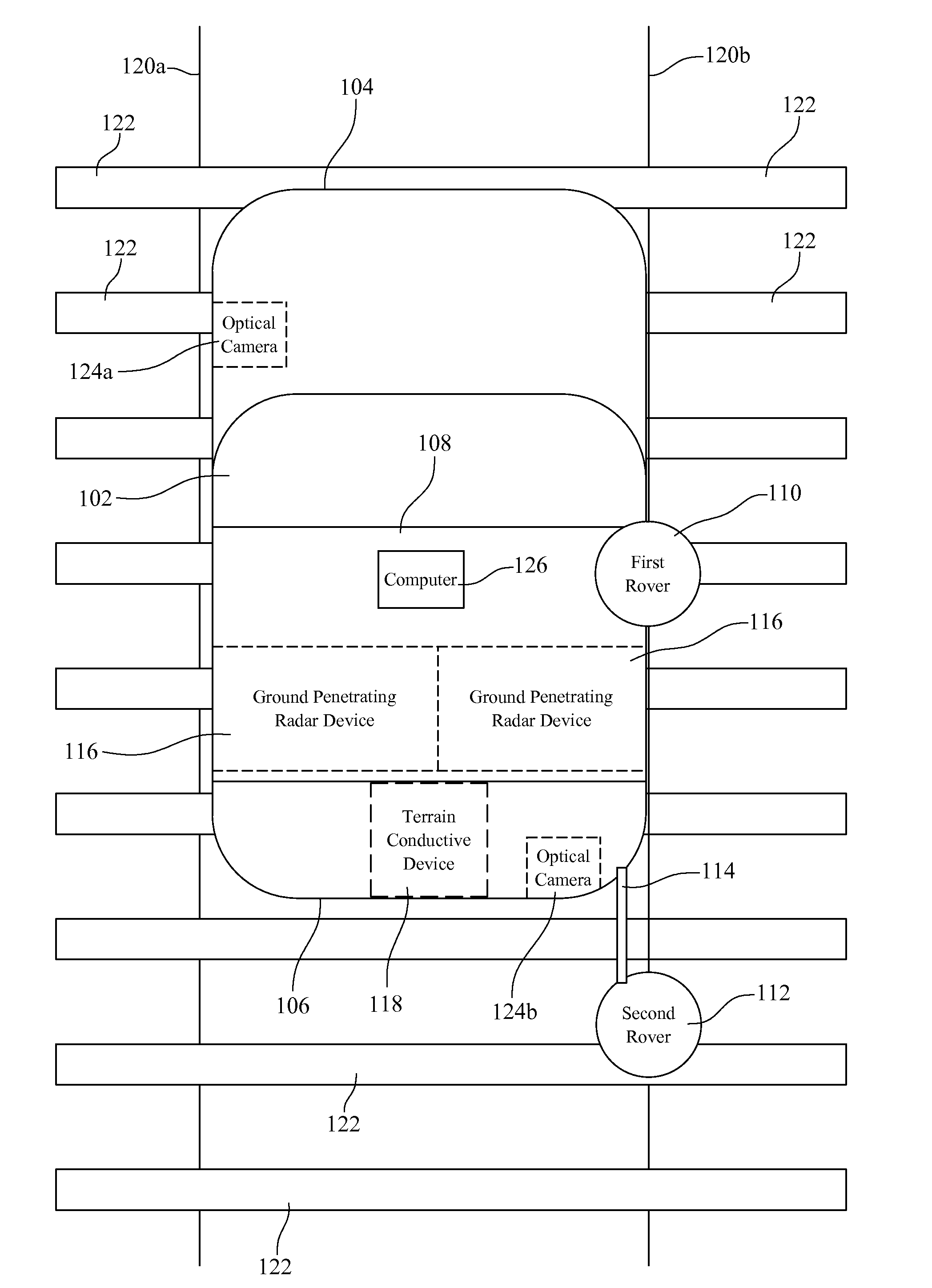
[0051]Preferred embodiments of the present invention herein described include an apparatus and method for multi-sensor railroad surveying and monitoring configured on a mobile platform. In one preferred embodiment as depicted in FIG. 1, is a mobile platform 102 having a roof rack 108. The front 104 and the rear 106 of the platform 102 are identified for convenience. A first rover 110 and a second rover 112 are attached to the platform 102 and in communication with a computer 126. In the preferred embodiment the computer 126 is attached to the mobile platform 102. The first rover 110 and the second rover 112 are positioned and aligned over the same track rail, e.g. rail 120b. For convenience purposes only, the present invention is described as surveying rail 120b. It would be readily apparent to one skilled in the art that the present invention can be applied to any rail, such as rail 120a. Also, the present invention is described in terms of a first and second rover 110, 112 for con...


PUM


Abstract

A Railroad Surveying and Monitoring System configured on a mobile platform for surveying, monitoring, and analyzing rail position and superstructure and terrain substructure of railroad tracks (20a,b) or other structures. The system employs two or more High Accuracy Differential Global Positioning System devices (110,112), ground penetrating radar devices (116), terrain conductivity instruments (118), optical cameras (124), and data receivers and processors (126), which in turn process, display, and store the data in a usable database. Precise coordinate data generated from a High Accuracy Global Positioning System provides both location data for subsurface sensors and surface sensors and rail position coordinates to monitor track displacements during track inspection in real time.

Description

CROSS-REFERENCE TO RELATED APPLICATIONS[0001]This application claims the benefit of U.S. Provisional Application No. 60 / 509,212 filed Oct. 6, 2003, and U.S. Provisional Application No. 60 / 509,213 filed Oct. 6, 2003.STATEMENT REGARDING FEDERALLY SPONSORED RESEARCH OR DEVELOPMENT[0002]The United States government has a paid-up license in this invention and the right in limited circumstances to require the patent owner to license others on reasonable terms as provided for by the terms of contract and regulations of the FRA Agency Award #DTFR53-03-G-00014, DTFR53-02-G-00020, DTFR53-01-G-00307, and DTFR53-00-G-60024.BACKGROUND OF THE INVENTION[0003]1. Field of Invention[0004]This invention pertains to a mobile railroad track surveying and monitoring apparatus and method, and more particularly, to a system employing High Accuracy Differential Global Positioning System receivers linkable with other non-invasive sensors for rail track superstructure and substructure surveying and monitoring...

Claims


Application Information

Patent Timeline
Patent Type & Authority Patents(United States)
IPC IPC(8): G01C22/00B61K9/08G01B5/20G01SG01S5/10G01S13/86G01S13/88G01S19/54
CPCB61K9/08B61L23/047E01B37/00G01S19/54G01S13/867G01S13/86G01S13/885
Inventor SZWILSKI, ANTHONY B.BEGLEY, RICHARD D.
Owner MARSHALL UNIV RES
Why Eureka
Try Eureka