Method for computing an energy efficient route

a route and energy-efficient technology, applied in the field of digital maps, can solve the problems of less efficient power generation of fuel/energy consumption into mechanical motion, more excessive heat, and high energy consumption, and achieve the effects of reducing pollution, energy-saving, and reducing travel speed

Active Publication Date: 2012-10-16
TOMTOM NAVIGATION BV
View PDF37 Cites 56 Cited by
  • Summary
  • Abstract
  • Description
  • Claims
  • Application Information

AI Technical Summary

Benefits of technology

[0016]The invention also contemplates a method for computing an energy efficient route between an origin location and a destination location in situations where a digital map includes a network of road segments or links extending between the origin and destination locations. Probe data is collected from probes traversing the links and then bundled and processed to obtain the Longitudinal Speed Profiles (LSPs) for each time span. Using these Longitudinal Speed Profiles (LSPs), an energy cost is calculated for at least one direction of travel supported by the link during each time span, so that a route can be planned between the origin and destination by analyzing the energy cost for alternative link combinations in the network and preferring those links which minimize the average energy consumption value.
[0019]This invention allows the user to plan routes containing less acceleration / deceleration points on the route and in addition to that possible lower travel speeds, thus allowing the engines to work in more efficient (closer to steady RPM) mode, which will deliver the wanted energy economy and also decrease pollution. Navigation systems operating route planning software can have an option to enter the time one can spend driving a particular optional route and see how “greener” the route will be for every time setting. Or, the person can enter the parameter of how much longer in % to the fastest time the more energy efficient route is allowed to be (as an example of one possible time setting).
[0020]A distinct advantage of this invention for planning an eco-friendly route does not necessarily require any vehicle-specific information to derive useful results, although more accurate computations can be made with the addition of vehicle-specific information. Thus, it is not absolutely necessary that the navigator know the type of vehicle the user has and what are the prices of the fuel in the nearby refueling stations. The proposed method of route planning thus takes advantage of generic knowledge about the efficiency of all vehicle engines / motors (that is, to drive with the fewest number of accelerations / decelerations) to deliver more economical routes. To this end, this method is also applicable to routing services occurring off-board or being retrieved over the web, such as on mapping and routing web sites used by internet users.

Problems solved by technology

During every acceleration, the engine (or motor in electric vehicle applications) generates more excessive heat, which means the power generated by the fuel / energy consumed is transferred less efficient into the mechanical motion and at higher speed the energy consumption is higher due to factors like air resistance.
Traditional brakes do not recover this energy, while electric motors may recover some energy.

Method used


Image

  • Method for computing an energy efficient route
  • Method for computing an energy efficient route
  • Method for computing an energy efficient route

Examples


Embodiment Construction

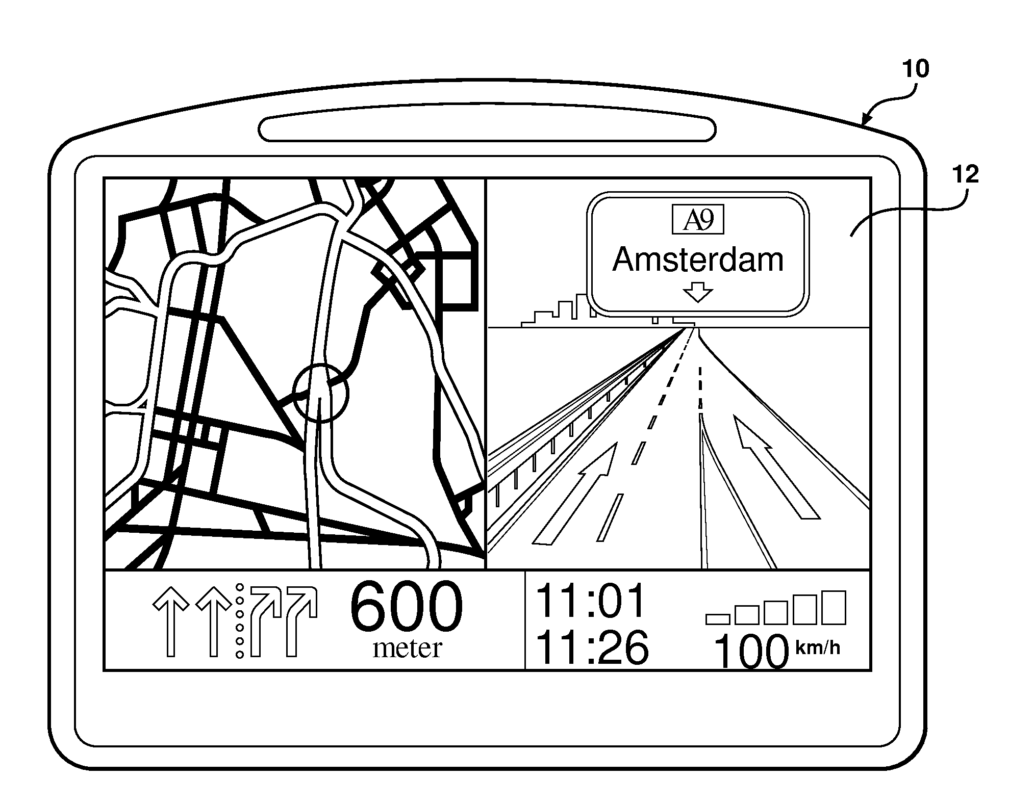
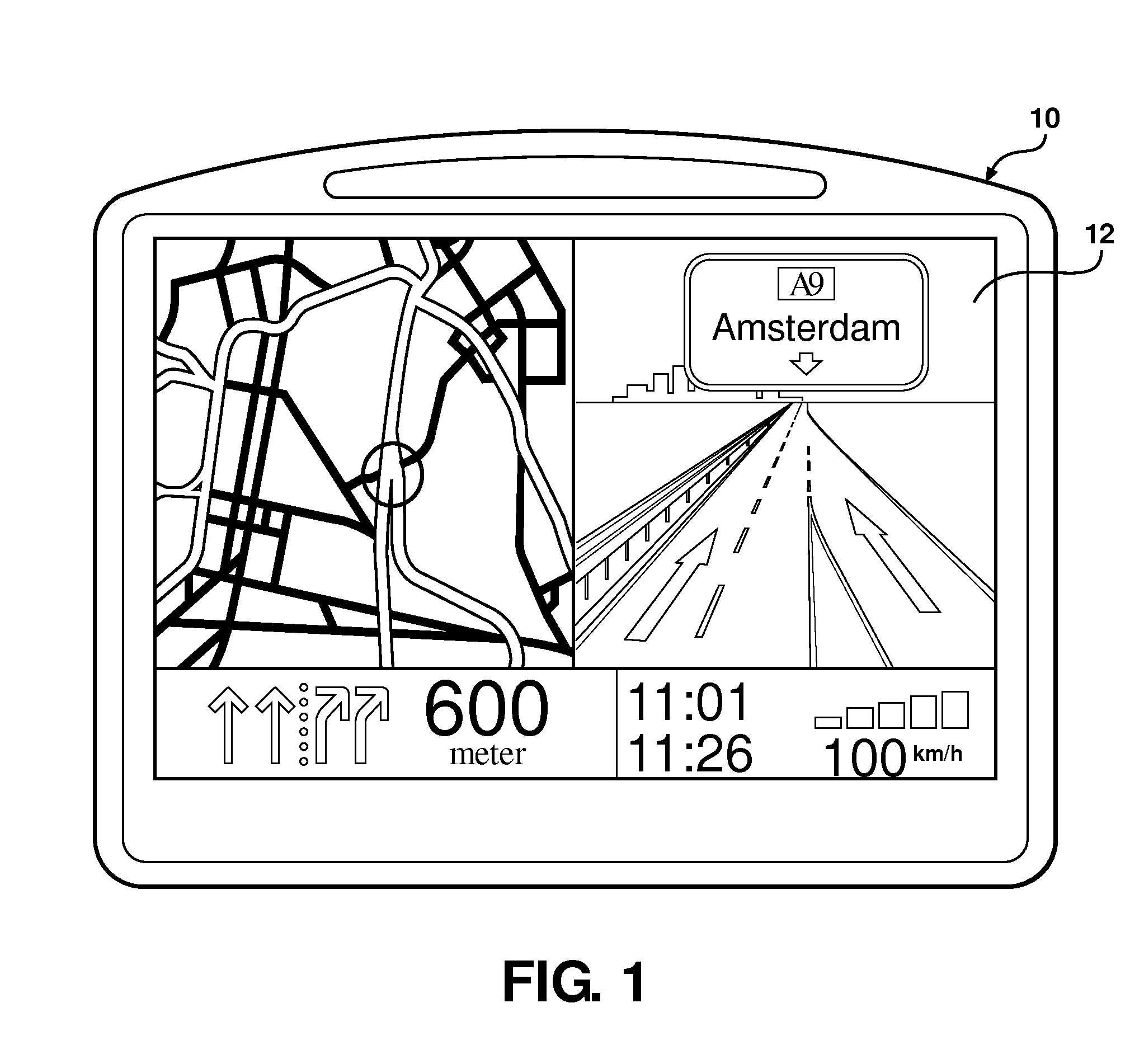
[0034]Referring to the Figures, wherein like numerals indicate like or corresponding parts throughout the several views, this invention pertains to position reading devices, navigation systems, ADAS systems with GNSS (Global Navigation Satellite System), and the digital maps used by navigation systems. This invention is therefore applicable to all kinds of navigation systems, position reading devices and GNSS enabled units including, but not limited to, handheld devices, PDAs, mobile telephones with navigation software, and in-car navigation systems operating as removable or built-in devices. The invention can be implemented in any type of standard navigation system available on the market, on mapping and navigation web sites / servers as far as energy efficient route planning is concerned, as well as suitable systems which may be developed in the future.

[0035]The navigation-capable device typically includes a computer readable medium having navigation software recorded thereon. A mic...


PUM


Abstract

Probe data is analyzed to derive Longitudinal Speed Profiles (LSPs) and an Optimal Longitudinal Speed Profile (18) for each road segment or link in a digital map network. The Longitudinal Speed Profiles (LSPs) profiles are calculated during defined time spans whereas the Optimal Longitudinal Speed Profile (18) is based on the LSP for the time span corresponding only to free flow traffic conditions. All of the LSPs can used to create a respective energy cost for each time span, or only the OLSP (18) can be used (or alternatively the RRDSL 16 or LRRDSL 17) to calculate an energy cost for the free flow conditions only. The energy cost can be used to predict the energy required by a vehicle to traverse the link. Navigation software can use the energy cost to plan the most energy efficient route between two locations in the digital map. Sensory signals can be activated if a driver strays from the Optimal Longitudinal Speed Profile (18) to achieve extremely high levels of energy efficiency.

Description

STATEMENT OF COPYRIGHTED MATERIAL[0001]This application is the National Stage of International Application No. PCT / EP2010 / 050363, filed Jan. 13, 2010 and designating the United States. The entire contents of this application is incorporated herein by reference.[0002]A portion of the disclosure of this patent document contains material which is subject to copyright protection. The copyright owner has no objection to the facsimile reproduction by anyone of the patent document or the patent disclosure, as it appears in the PTO patent file or records, but otherwise reserves all copyright rights whatsoever.BACKGROUND OF THE INVENTION[0003]1. Field of the Invention[0004]This invention relates to digital maps of the type for displaying road or pathway information, and more particularly toward a method for supplementing a digital map with data to enable various traffic modeling actions and to calculate an energy efficient route that can be offered to a driver.[0005]2. Related Art[0006]Perso...

Claims


Application Information

Patent Timeline
Patent Type & Authority Patents(United States)
IPC IPC(8): G08G1/00
CPCG01C21/32G01C21/3469Y02B60/42Y02D30/00G01C21/3492
Inventor HIESTERMANN, VOLKERVAN ESSEN, ROBERT JOANNESBASTIAENSEN, EDWINT'SIOBBEL, STEPHEN
Owner TOMTOM NAVIGATION BV
Why Eureka
Try Eureka