Synthetic underwater visualization system

a visualization system and underwater technology, applied in the field of bathymetry, can solve the problems of loss of temporal resolution and thus depth resolution, the most difficult problem to overcome, and the scattering of probe pulses, etc., and achieve the effect of promoting widespread utilization and being readily adaptabl

Active Publication Date: 2017-07-11
APPAREO SYST
View PDF0 Cites 52 Cited by
  • Summary
  • Abstract
  • Description
  • Claims
  • Application Information

AI Technical Summary

Benefits of technology

[0020]The present invention is a modular, mobile synthetic underwater visualization system (SUVS). SUVS is a commercially-viable, augmented reality (AR) system made possible by the development of a highly-sophisticated and innovative real-time graphics software engine and a sophisticated new underwater environmental sensor. Mobile components of the system will be complimented by a fixed-base data storage and retrieval system designed to accept and assimilate into a common database bathymetric and environmental information acquired from around the world by the mobile SUVS units. SUVS is capable of sensing, modeling and realistically displaying underwater environments in real-time. This technology will foster widespread utilization, and will play an important role in areas of homeland security, commercial and recreational maritime navigation, bathymetric data collection, and environmental analysis. The technology is also readily adaptable and highly desirable in non-marine applications.
[0021]The SUVS underwater visualization system is based on two innovations. The first innovation is an advanced terrain rendering graphics software engine capable of acquiring and incorporating large amounts of streaming real-time data into preprocessed terrain maps, and capable of generating geospatially-synchronized, highly-detailed, three-dimensional images. This rendering engine is designed to run on a very low-cost hardware platform.

Problems solved by technology

Because of the profound low-cost, the technical capabilities of the envisioned system, and the fact that data acquired from all systems will be combined into a single database or other appropriate centralized repository, the world will gain unparalleled knowledge of underwater environments such as lakes, rivers, and coastlines.
The scattering of the probe pulse is the most challenging problem to overcome.
An additional affect will be the “blurring” of the target point, such that a larger area will be probed than desired, and the intensity of the leading edge of the return beam is attenuated, which potentially leads to loss of temporal resolution and thus depth resolution.
However, in “imaging” mode, the field of view can be limited to a small portion of the illuminated spot size on the target.
This real-time requirement adds a new level of complexity to the 3D rendering algorithms.
For example, in aviation a great deal of effort is being put into creating realistic 3D visualization systems as a result of the FAA's Terrain Awareness and Warning (TAWS) mandate.
These “synthetic vision” systems, as they are sometimes called, are starting to be available but cost tens of thousands of dollars and so are far from reaching broad distribution.
These systems are far from perfect and transportation is often disrupted, resulting in an overall slowing of our economic engines.
As fundamental advancements of broad-based technologies overcome key barriers the ripple effect in products and industry is hard to predict.
What is known, however, is that affordable high-definition sensors are lacking for marine and non-marine applications alike while the applications for them in navigation, security, remote sensing, and information gathering are endless.

Method used


Image

  • Synthetic underwater visualization system
  • Synthetic underwater visualization system
  • Synthetic underwater visualization system

Examples


Embodiment Construction

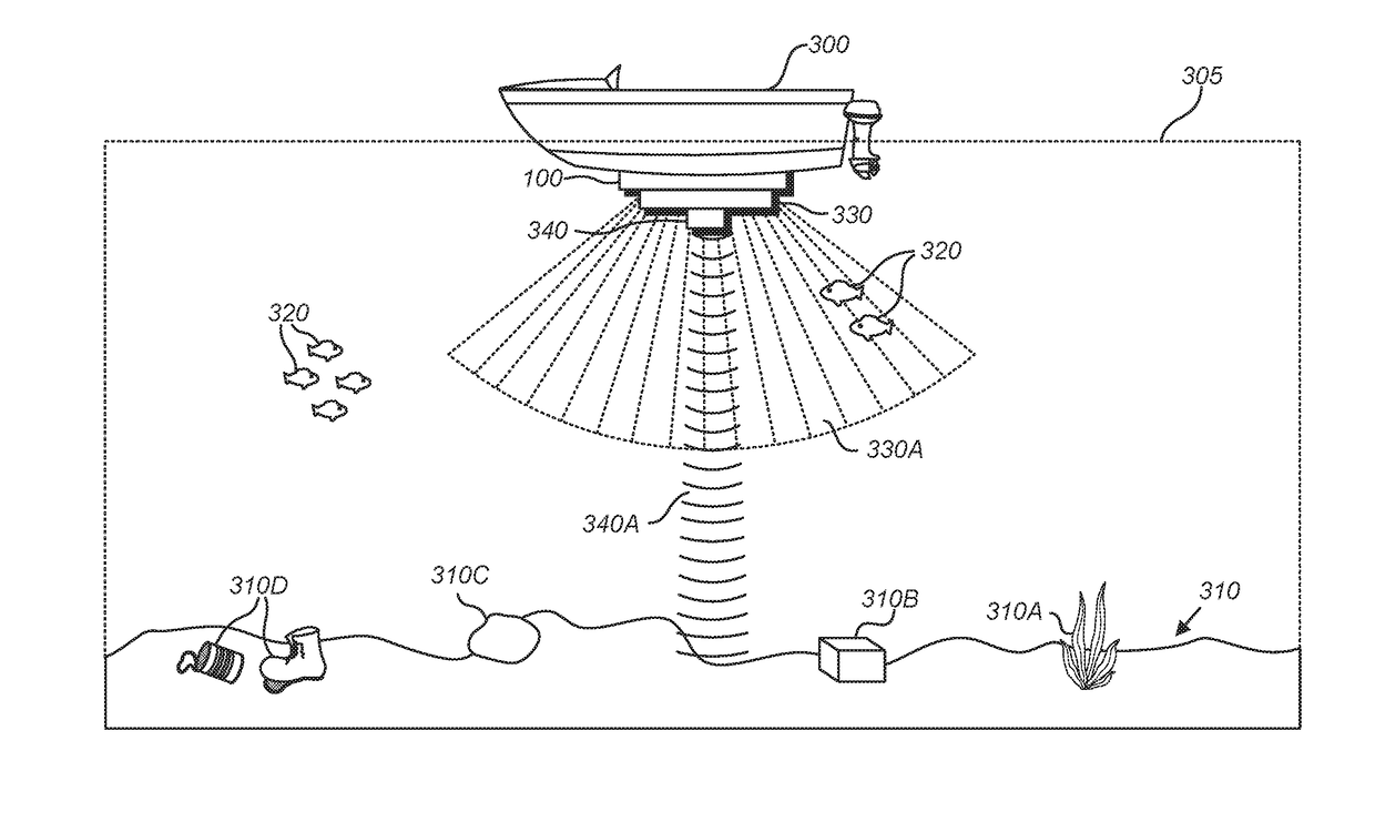
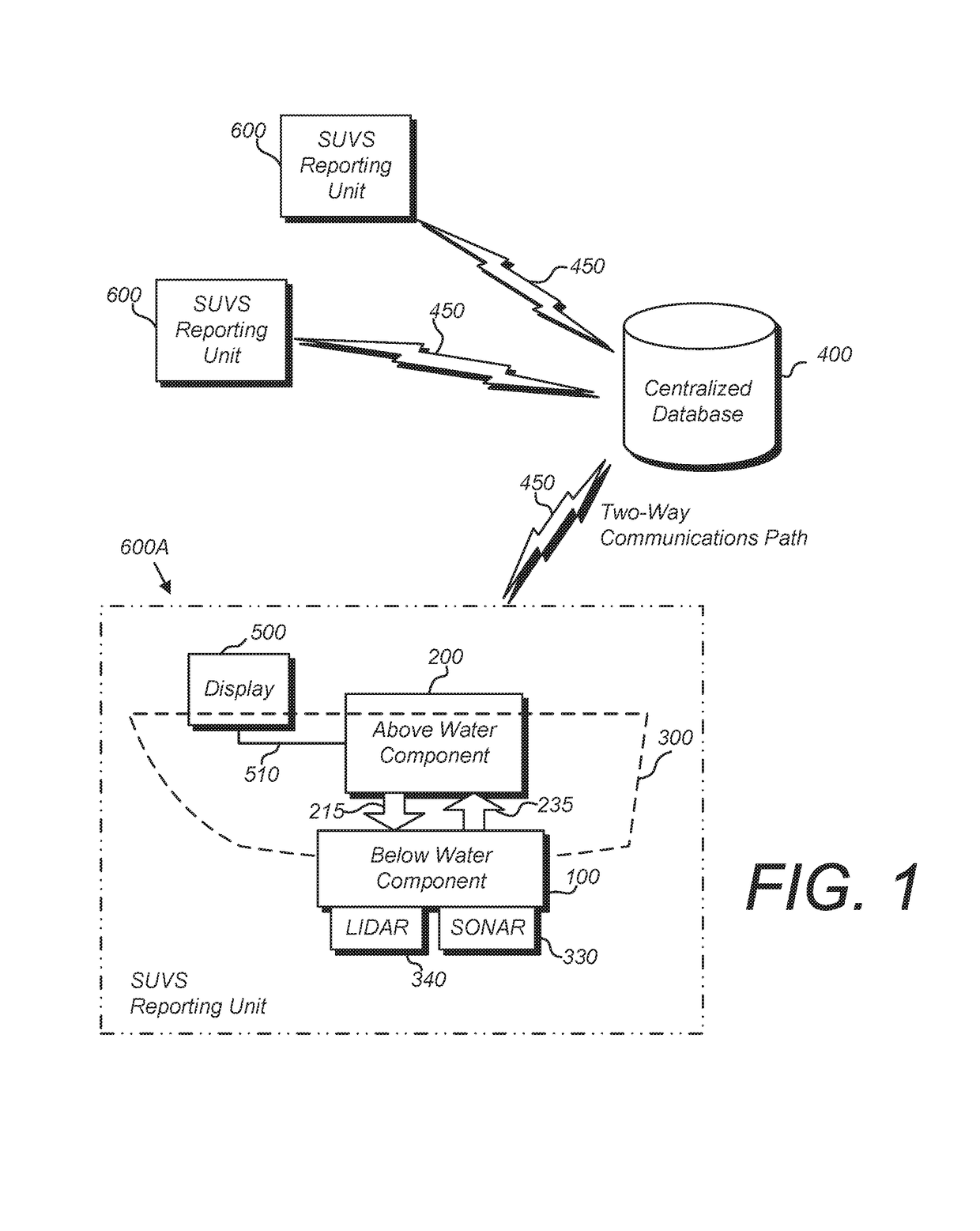
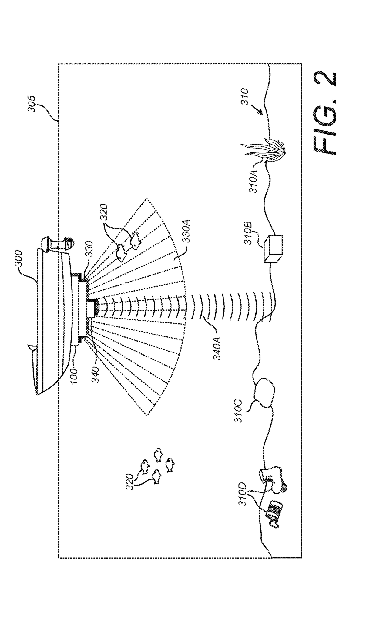
[0029]For the purposes of this specification, the following terms have been defined:[0030]3D Three Dimensional[0031]AI Artificial Intelligence[0032]IG Image Generator[0033]ALB Airborne LIDAR Bathymetry[0034]APD Avalanche Photodiode[0035]API Application Program Interface[0036]AR Augmented Reality[0037]ASIC Applications Specific Integrated Circuit[0038]CPU Central Processing Unit[0039]DARPA Defense Advanced Research Projects Agency[0040]Eutrophic Shallow, warm, mud bottom lakes with high sediment levels and which are high in nutrients[0041]FAA Federal Aviation Administration[0042]FCS Future Combat Systems[0043]GIS Geographic Information Systems[0044]GNSS Global Navigation Satellite System[0045]GPS Global Positioning System[0046]GPU Graphics Processing Unit[0047]IG Image Generator[0048]JALBTCX Joint Airborne LIDAR Bathymetry Technical Center of Expertise[0049]LIDAR Laser Identification Detection and Ranging[0050]LOD Level of Detail[0051]MEMS Micro Electro-Mechanical Systems[0052]MMOG M...


PUM


Abstract

A synthetic underwater visualization system (SUVS) comprising a real-time graphics software engine, a sophisticated underwater environmental sensor, a fixed-base database, and a retrieval system designed to accept and assimilate into a common database bathymetric and environmental information acquired from around the world by components of other deployed SUVS sensing systems. SUVS is capable of sensing, modeling, and realistically displaying underwater environments in real-time, and will foster widespread utilization in the areas of homeland security, commercial and recreational maritime navigation, bathymetric data collection, and environmental analysis. The technology will also be readily adaptable and highly desirable in non-marine applications.

Description

BACKGROUND OF THE INVENTION[0001]Field of the Invention[0002]The present invention relates generally to the field of bathymetry, and specifically to a system for creating a detailed synthetic visualization of an underwater environment.[0003]Description of the Related Art[0004]Current technology used for bathymetry and underwater visualization is deficient in two critical areas: sensors are incapable of high-resolution three-dimensional measurement, and software is incapable of realistically representing large, complex, dynamically changing underwater environments in real-time. As a result of these deficiencies, it has not previously been possible to develop and commercialize low-cost, high-resolution, real-time, three-dimensional underwater visualization systems.[0005]Current State-of-the-Art Underwater Sensors:[0006]Objects on the ocean floor that threaten navigation or national security in coastal waters, such as bottom-mounted mines, and other objects of military or commercial in...

Claims


Application Information

Patent Timeline
Patent Type & Authority Patents(United States)
IPC IPC(8): G01S15/00G01S17/89G01S7/00G01S15/02G01S7/62G01S15/89G01S15/86
CPCG01S15/025G01S15/8902G01S17/89G01S7/003G01S7/6245G01S7/6272G01S15/86
Inventor BATCHELLER, BARRY D.JOHNSON, JEFFREY L.ASLAKSON, DEREK B.
Owner APPAREO SYST
Why Eureka
Try Eureka