Land cover change detection method based on remote sensing image processing

A remote sensing image processing and remote sensing image technology, applied in the field of image processing, can solve the problems of being easily affected by noise, limiting wide application, consuming a lot of time and memory, and saving computing time and reducing the amount of calculation.

Inactive Publication Date: 2008-05-28
BEIJING HAOWANGJIAO IMAGE TECH
View PDF5 Cites 0 Cited by
  • Summary
  • Abstract
  • Description
  • Claims
  • Application Information

AI Technical Summary

Problems solved by technology

For the eight-neighborhood case, there are 8 neighbor points that affect the segmentation result of the current point, which is easily affected by noise, resulting in over-segmentation, and merging over-segmented areas will consume a lot of time and memory
Therefore, when segmenting large-scale remote sensing images, the wide application of this algorithm is largely limited.

Method used


Image

  • Land cover change detection method based on remote sensing image processing
  • Land cover change detection method based on remote sensing image processing
  • Land cover change detection method based on remote sensing image processing

Examples


Embodiment Construction

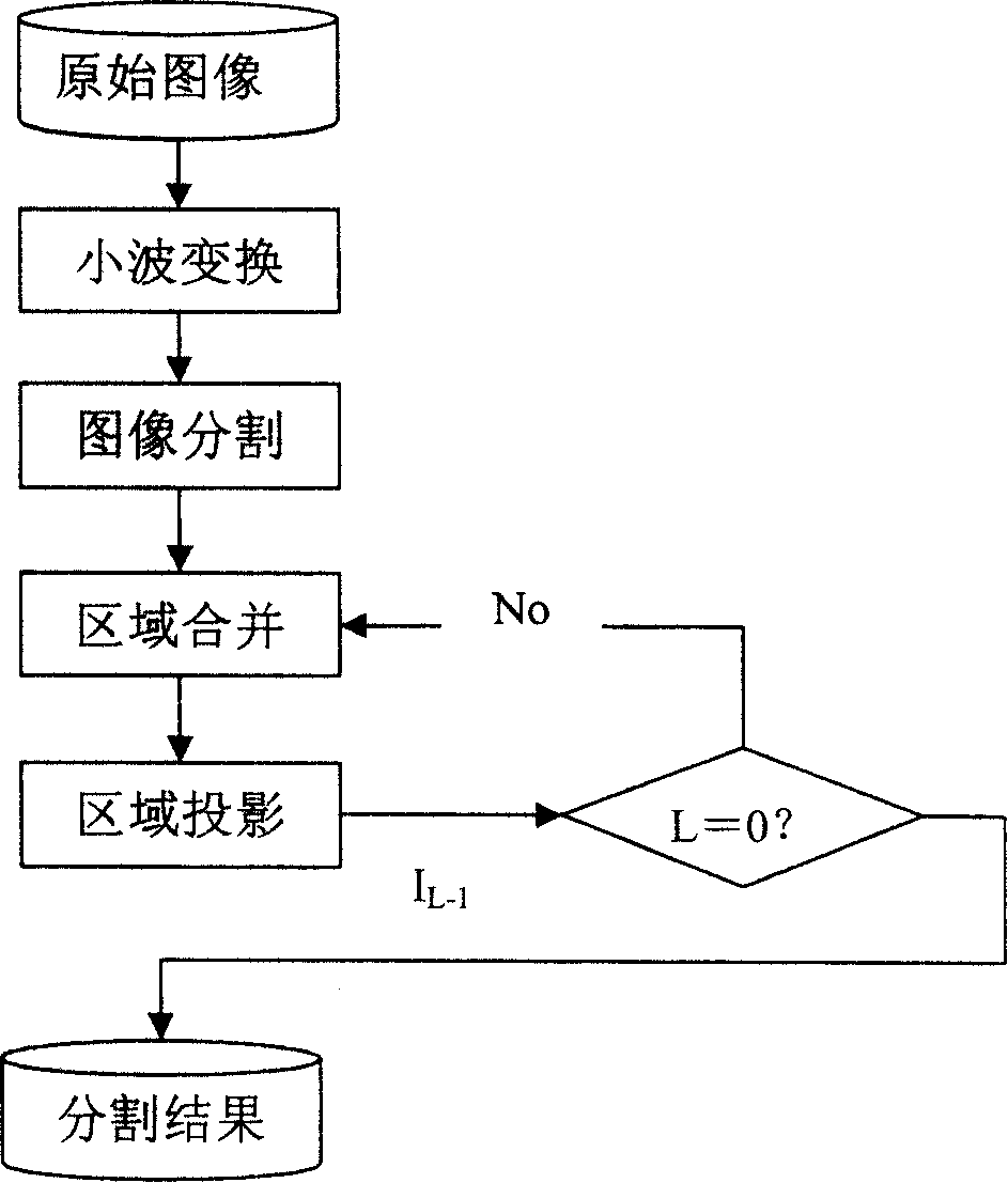
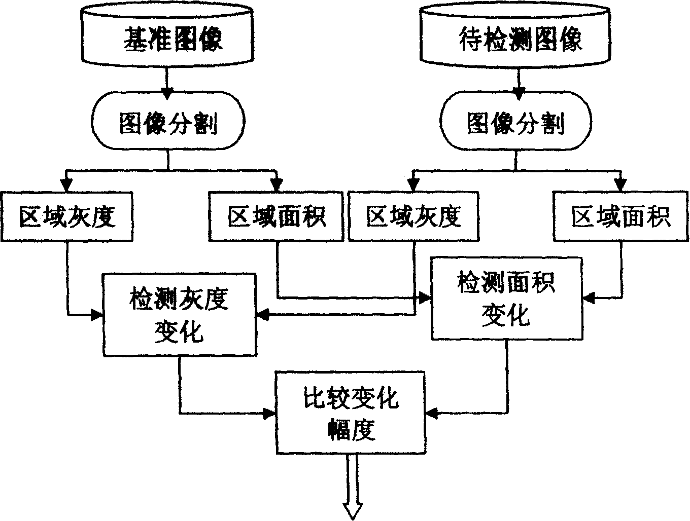
[0035] The implementation example of using the method of the present invention to realize change detection is as follows Figure 1 ~ Figure 3 As shown, it will be described in detail in conjunction with the figure.

[0036] The implementation process of the image segmentation described in the present invention is as follows figure 1 As shown, its working process is:

[0037] 1) Haar wavelet transform is performed on the entire image, and the gradient of the lowest resolution image is calculated;

[0038] 2) Perform initial segmentation with Watersheds transformation on the gradient image to form many initial segmentation regions, and assign a label to each region;

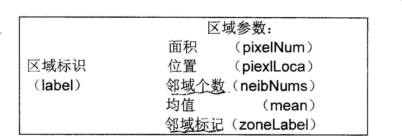
[0039] 3) After the initial segmentation is completed, the feature values ​​of the statistics area include: area, mean value, position, number of neighbors and neighbor label (label);

[0040] 4) Merge segmented regions: Merge regions according to the gray similarity of adjacent regions. If the square difference...


PUM


Abstract

The invention relates to a method for detecting the change of earth's surface, based on remote sensing image processing, which comprises following steps: 1, cutting the standard image and the detected image, to attain cut result image, while each cut section of result image has a section gray characteristic value and section area characteristic value; 2, point-to-point processing following judgments according to said section gray scale and section area change amplitude: if the section gray scale changes, but the section area not, said change is a false change; or else if the section area changes, but the section gray scale not, it is a false change; if the gray scale and the area both change, using the moment with small change as the measure valve of earth' surface change. With said invention, user can attain accurate detect result on the change of earth' surface by the remote sensing image.

Description

technical field [0001] The invention relates to image processing technology and its application, in particular to a method for detecting changes in the ground surface based on remote sensing image processing. By using this method, the authenticity of the changed area can be distinguished more conveniently, so that a more accurate detection result of the surface change can be obtained through the remote sensing image. Background technique [0002] With the further development of sensor technology, aviation and aerospace platform technology, and data communication technology, the information provided by remote sensing will increase at an unimaginable rate. Theories and technologies such as how to accurately and quickly use remote sensing data to find changes, and how to automatically extract changing areas from images are of great significance to the future development of remote sensing technology. At present, the commonly used change detection methods are mainly divided into...

Claims


Application Information

Patent Timeline
Patent Type & Authority Patents(China)
IPC IPC(8): G01S17/89
Inventor 徐岩唐娉
Owner BEIJING HAOWANGJIAO IMAGE TECH
Why Eureka
Try Eureka