Water depth surveying boat

A water depth measurement and ship hull technology, which is applied in measurement devices, open-air water source surveys, radio wave measurement systems, etc., can solve problems such as speeding up, and achieve the effect of small size, light weight, easy handling and traction

Inactive Publication Date: 2009-12-09
POWERCHINA ZHONGNAN ENG
View PDF0 Cites 13 Cited by
  • Summary
  • Abstract
  • Description
  • Claims
  • Application Information

AI Technical Summary

Problems solved by technology

However, for underwater topographic surveys or bathymetry surveys in deep mountains and canyons in the west and turbulent river sections where it is impossible to sail safely, personal safety and equipment safety are the most important. How to adopt advanced surveying equipment and new technologies and new methods , under the premise of ensuring safety, it has become an important topic to solve the problem of sounding, speed up the work progress and save costs

Method used


Image

  • Water depth surveying boat
  • Water depth surveying boat
  • Water depth surveying boat

Examples


Embodiment Construction

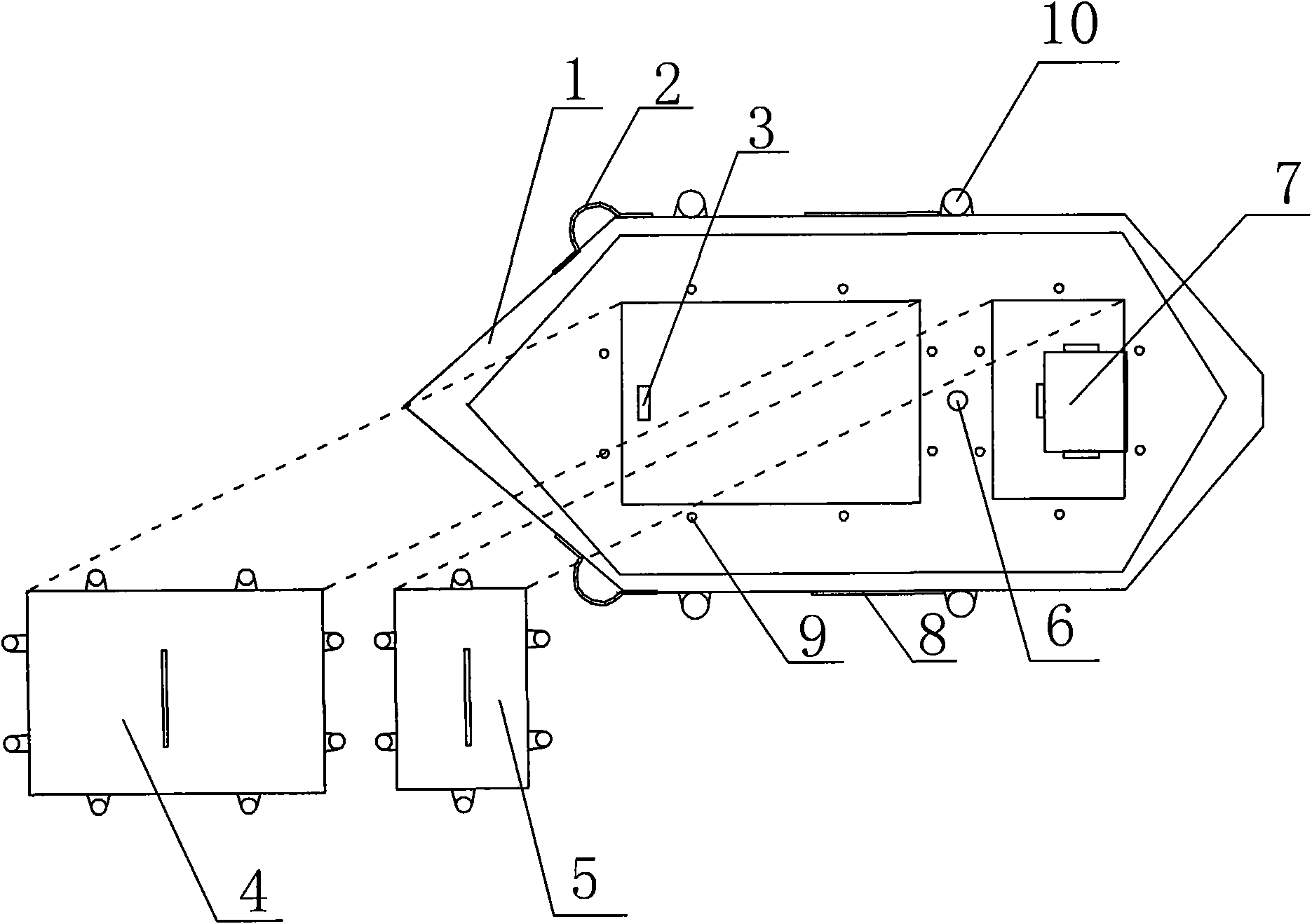
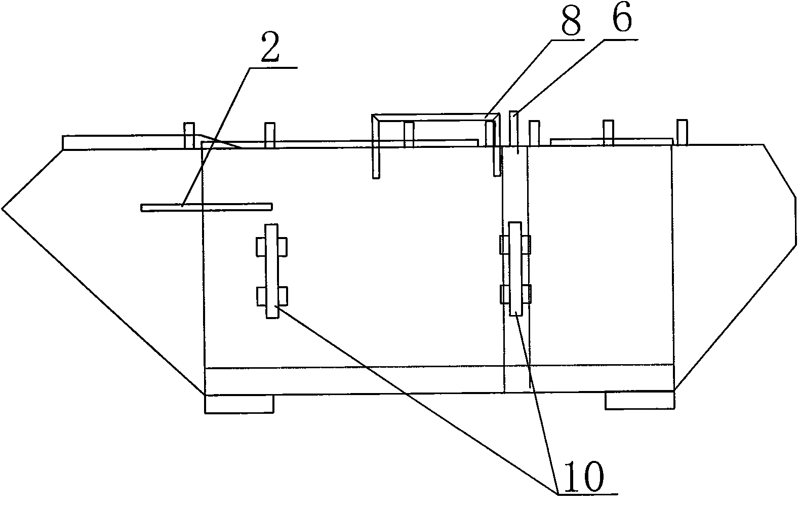
[0020] refer to figure 1 and figure 2 , the water depth measurement ship consists of a hull 1, a working compartment, a front cover of the working compartment 4, a rear cover of the working compartment 5, a handle 8, a towing hook 2, a GPS antenna placement device 6, a battery installation position 7, and an instrument installation Position 3, protection fixing device 10 and depth sounder probe installation hole 11, etc., wherein the instrument installation position 3 and battery installation position 7 set in the working compartment are used to place the depth sounder, GPS locator and working battery respectively It is fixed in the warehouse, and the working warehouse is fixed and sealed by the front cover plate 4 of the working warehouse and the rear cover plate 5 of the working warehouse through the cover fixing screw 9.

[0021] The lifting hands 8 on both sides of the hull are used for carrying, and a stay rope can be fixed on the tow hook 2, and the operator pulls the ...


PUM


Abstract

The invention discloses a water depth surveying boat, comprising a boat body and a sealed cabin sealed by cover board in the boat body. The sealed cabin comprises a working cabin having apparatus installing location and battery installing location. A pull hook is equipped at one side of said boat body; the bottom of boat body is set with an internal tester probe installing hole, which is set with a protective cover, the central location of which is set with a round hole having the same size with the ultrasonic wave generating device of tester probe. The water depth surveying boat solves the difficulty of water depth survey caused by that river segments with a lot of beaches, rapid water flow and large fall cannot be connected by boats. The water depth surveying boat is made of steel sheet with small volume and light weight, so the boat can be pulled by ashore staff to survey the water depth. The device is simply designed, conveniently operated, installed with less assembly, lower cost and mature technique and fit for complicated river segments.

Description

technical field [0001] The invention relates to a fixing device for underwater terrain surveying or bathymetry carrying measurement equipment, especially suitable for special dangerous waters where personnel boarding poses great dangers for underwater topography surveying or bathymetry. Background technique [0002] Underwater terrain surveying technology is a relatively mature surveying and mapping technology applied in the hydropower surveying and mapping industry. The water depth measurement equipment is usually a depth sounder, and the coordinate positioning methods include total station method, dual-frequency GPS RTK method, and cross-section endpoint method. However, for underwater topographic surveys or bathymetry surveys in deep mountains and canyons in the west and turbulent river sections where it is impossible to sail safely, personal safety and equipment safety are the most important. How to adopt advanced surveying equipment and new technologies and new methods ...

Claims


Application Information

Patent Timeline
Patent Type & Authority Applications(China)
IPC IPC(8): B63B35/00G01C13/00G01B17/06G01F23/296G01S5/02G01S1/02
Inventor 贺秋伟高玉旺龚楚安吕耕超
Owner POWERCHINA ZHONGNAN ENG
Why Eureka
Try Eureka