On-line ortho-rectification method and system for remote sensing image

A remote sensing image and orthorectification technology, applied in radio wave measurement system, image analysis, utilization of re-radiation, etc., can solve the problems of DEM data network transmission security, DEM network transmission speed problem, insecure image control point database, etc. Achieve the effect of reducing data traffic, shortening processing cycles, and reducing software and hardware costs

Active Publication Date: 2010-03-31
CHINESE ACAD OF SURVEYING & MAPPING
View PDF0 Cites 21 Cited by
  • Summary
  • Abstract
  • Description
  • Claims
  • Application Information

AI Technical Summary

Problems solved by technology

[0008] However, this orthorectification service solution still has insecurity and other problems: First, the image control point database is still insecure
Therefore, there are two problems that need to be solved in the orthorectification service: one is the DEM network transmission speed problem; the other is the network transmission security problem of DEM data

Method used


Image

  • On-line ortho-rectification method and system for remote sensing image
  • On-line ortho-rectification method and system for remote sensing image
  • On-line ortho-rectification method and system for remote sensing image

Examples


Embodiment Construction

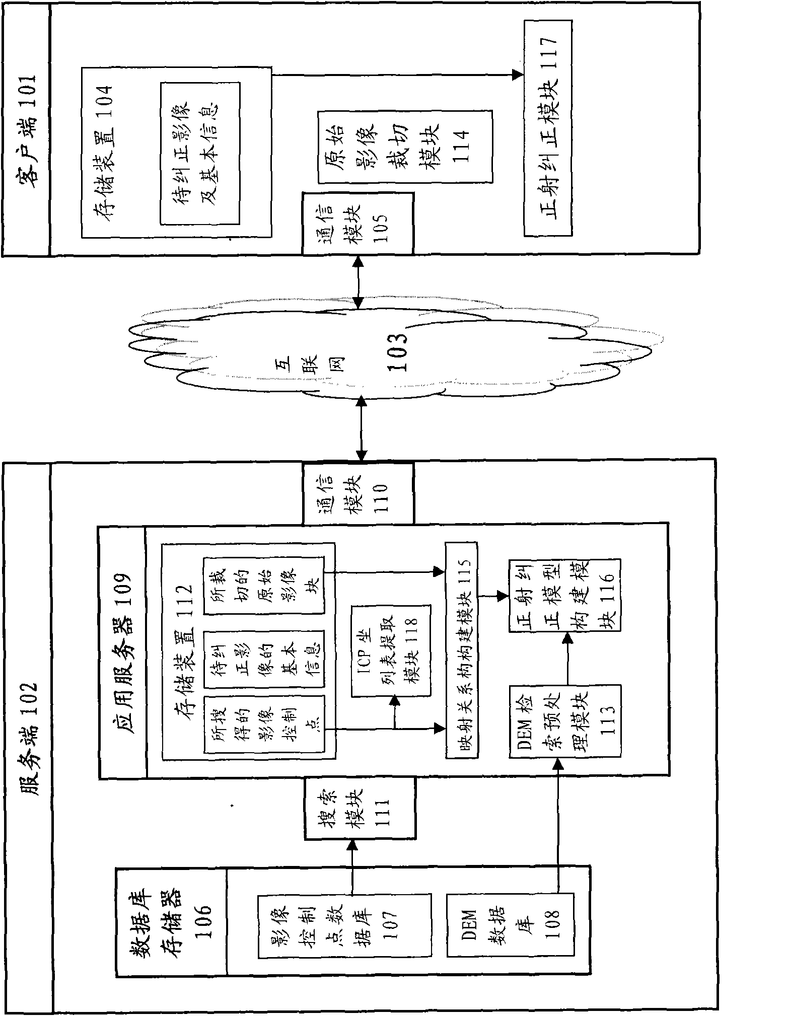
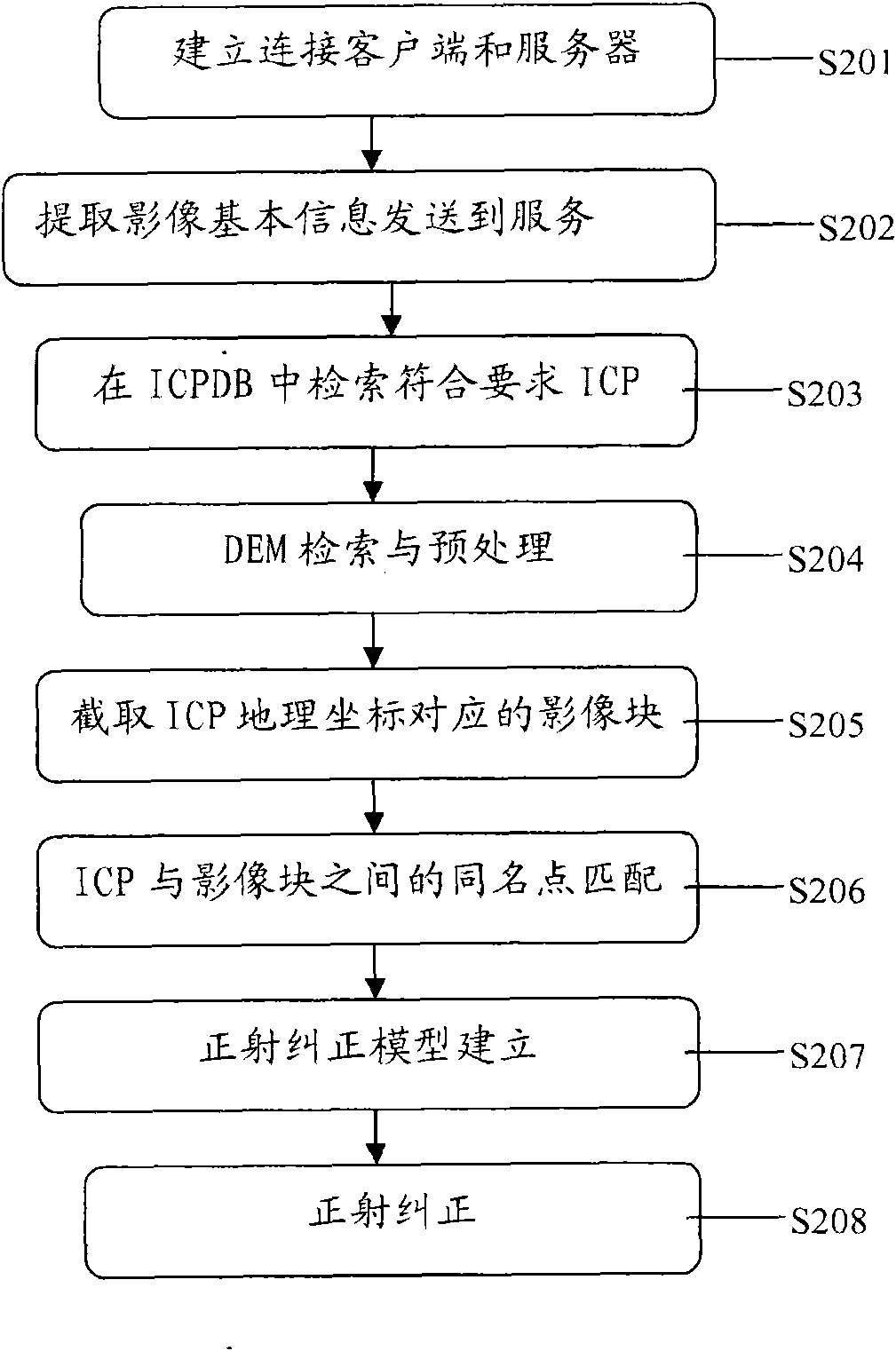
[0019] According to the remote sensing image online orthorectification system 100 of the present invention, the system includes a client 101 and a server 102, the server 102 and the client 101 are connected via the Internet 103, wherein the system 100 further includes: client storage The device 104 is configured to store the original remote sensing image and parameters related to the basic information of the remote sensing image. The basic information extracted from the header file includes image type, imaging time, resolution, number of rows and columns, initial geographic coordinate range, and RPC parameters.

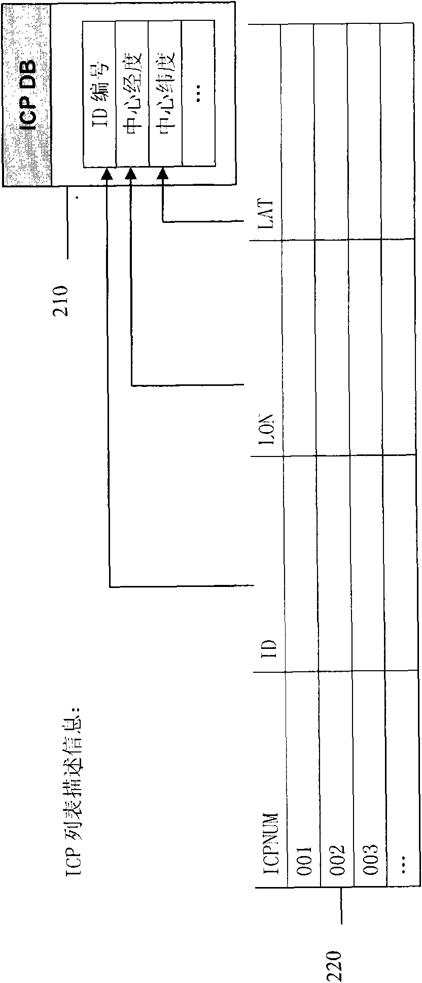
[0020] Spatial range information refers to the geographic space range information covered by the image to be corrected, which is mainly used for image positioning and determination of the search range of image control points. The image type refers to the sensor type information of the image, the storage format of the image, and other information.

[0021] Regarding t...


PUM


Abstract

The invention discloses an on-line ortho-rectification method for a remote sensing image, which comprises that: a client is connected to a server of a server side through an internet; the client extracts basic information from an original remote sensing image, and sends the extracted basic information to the server; the server searches an image control point matched with the basic information in an image control point database of the server side based on the basic information of the original remote sensing image of the client, stores the image control point in a storage device of the server, and simultaneously sends a coordinate of the searched image control point to the client; the client intercepts an image film of which the size is greater than that of the image control point in the original remote sensing image based on the coordinate of the image control point of the server, and sends the intercepted original image film to the server; the image control point stored in the storagedevice of the server and the received original image film from the client are subjected to identical point matching to acquire a mapping relationship of both, and an ortho-rectification model is constructed based on the mapping relationship, and is sent to the client; and the client performs the ortho-rectification on the whole original remote sensing image based on the received ortho-rectification model. The invention also relates to an on-line ortho-rectification system for the remote sensing image.

Description

technical field [0001] The invention relates to a method for orthophoto correction of remote sensing images, and more particularly to a method for performing orthophoto correction on remote sensing images on the Internet. Background technique [0002] With the development of remote sensing technology, especially the continuous development of remote sensing sensor technology, the use of remote sensing images or data obtained by remote sensing technology is becoming more and more extensive. At present, the application scope of remote sensing data has been extended to the field of social information services, for example, it is widely used in surveying and mapping, agriculture, forestry, geology and minerals, hydrology and water resources, environmental monitoring, natural disasters, regional analysis and planning, military, land use etc. Remote sensing images with precise geocoding can provide the features and information they need for land, planning, environmental protection...

Claims


Application Information

Patent Timeline
Patent Type & Authority Applications(China)
IPC IPC(8): G06T7/00G06F17/30G01S17/89
Inventor 唐新明王华斌李参海吴岚田娇娇王光辉
Owner CHINESE ACAD OF SURVEYING & MAPPING
Why Eureka
Try Eureka