Semi-automatic digital method of non-standard map

A non-standard, semi-automatic technology, applied in image data processing, image communication, image enhancement, etc., can solve the problems of lack of accurate and efficient vectorization methods, inappropriate use of non-standard vector maps, increasing the difficulty of digitization, etc. Working cycle, high image processing efficiency, and the effect of improving digitization accuracy

Inactive Publication Date: 2012-11-28
ZHEJIANG UNIV
View PDF2 Cites 21 Cited by
  • Summary
  • Abstract
  • Description
  • Claims
  • Application Information

AI Technical Summary

Problems solved by technology

However, digitization methods for standard paper vector maps are not suitable for non-standard vector maps
Due to the ubiquitous problems of non-standard paper vector maps such as unclear lines, uneven thickness of lines or frequent broken lines, the prevalence of these problems greatly increases the difficulty of digitization
If the existing automatic digitization method for standard paper vector maps is adopted, a large number of discontinuous vectorized lines will be generated due to the existence of the above problems, and manual intervention is required for interpretation and correction, which increases the workload; if the current application is more The common conventional manual digitization method is heavy workload and low efficiency
The ubiquity of these problems has greatly increased the difficulty of digitization. The existing technology lacks accurate and efficient vectorization methods for the digitization of non-standard vector maps.

Method used


Image

  • Semi-automatic digital method of non-standard map
  • Semi-automatic digital method of non-standard map

Examples


Embodiment Construction

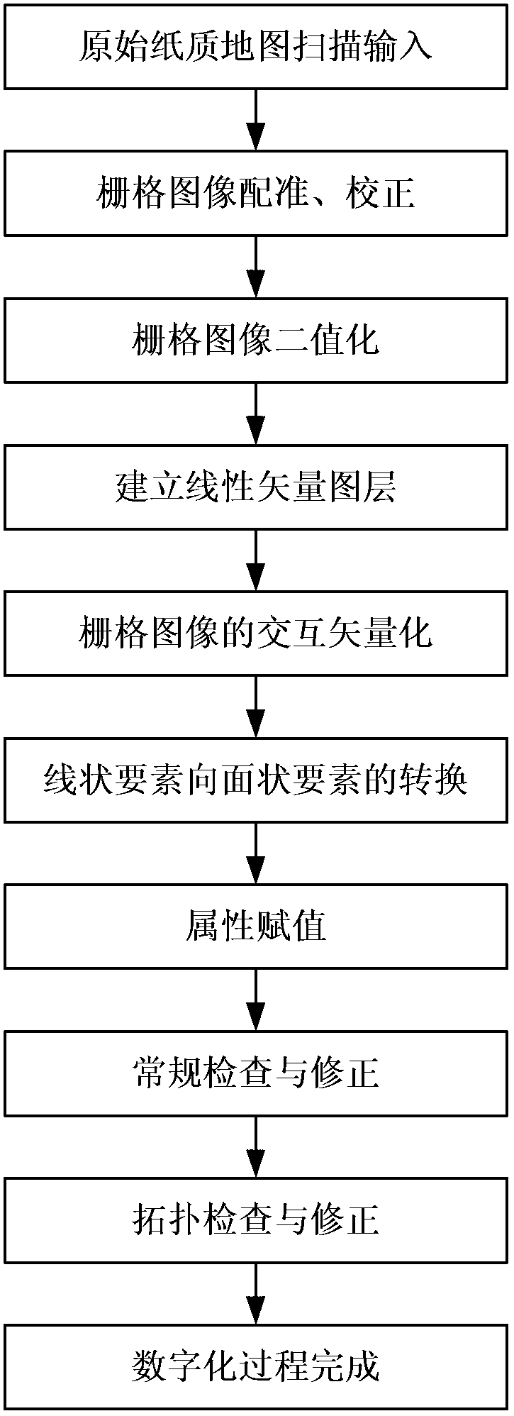
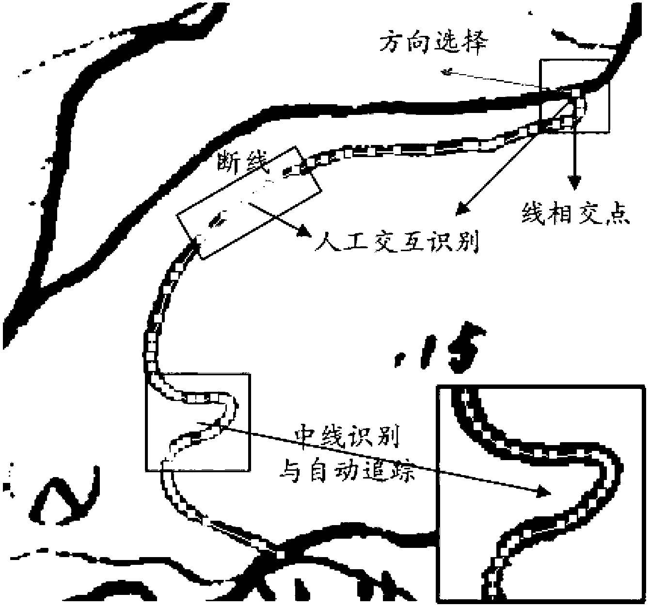
[0022] Adopt the most commonly used ArcMap 9.3 software platform in the embodiment of the present invention (some other geographic information system software platforms can also be realized), in conjunction with the 1: 50,000 soil map of each county (district) in Zhejiang province as the non-standard map of input Take an example to explain in detail. The 1:50,000 soil map in this example comes from the second soil census in Zhejiang Province. Since this soil census was carried out in units of counties (districts), the quality of soil maps among counties is uneven and the standards are different. one. Soil maps in most counties do not have kilometer grids or latitude and longitude grids, and the registration of soil maps can only refer to topographic feature points, which affects the registration accuracy of soil maps to a certain extent. Restricted by technical conditions, workload and time at that time, the 1:50,000 soil maps of each county (district) were hand-painted, with...


PUM


Abstract

The invention discloses a semi-automatic digital method of a non-standard map. The method comprises the following steps of: 1) scanning to obtain a grid image, and performing geographical space registration and correction and binarization; 2) establishing a linear vector layer and assigning a geographical space reference system consistent with the corrected grid image; 3) overlapping the linear vector layer on the grid image after the binarization, identifying and capturing the center lines of the lines in the grid image, automatically tracking the captured center lines of the lines in the grid image one by one, and performing line breakage and endpoint artificial judgment on each automatically tracked line, and performing vectorization to obtain a vector image; 4) performing attribute assignment, check and correction; and 5) re-establishing the topological relation of the vector image, and checking and correcting the topological errors such as overlapping and gap to obtain a vector image after digitalization. The method disclosed by the invention has the advantages of good image processing accuracy, high image processing efficiency, low processing workload, short processing period and wide application range.

Description

technical field [0001] The invention relates to graphic digitization technology, in particular to a semi-automatic digitization method suitable for township planning maps, agricultural and forestry zoning maps, non-standard maps in fields such as soil, topography, geology and hydrology. Background technique [0002] So far, all walks of life have compiled and accumulated a large amount of paper-based line maps (vector maps), some of which are very old and inevitably damaged and obsolete. For example, between 1979 and 1985, the second national soil survey was carried out, and most townships completed 1:10,000 soil maps, and counties (districts) completed 1:50,000 soil maps. Most of these maps are done by hand, there is no unified requirement and standard, and there is no official publication. The quality of maps in different places may vary greatly. We call these maps non-standard vector maps. [0003] With the rapid development of information science, space technology, and ...

Claims


Application Information

Patent Timeline
Patent Type & Authority Applications(China)
IPC IPC(8): G06T5/00H04N1/04
Inventor 支俊俊荆长伟林声盼吴嘉平
Owner ZHEJIANG UNIV
Why Eureka
Try Eureka