Method for inverting effective leaf area index by utilizing geometric projection and laser radar

An area index, lidar technology, applied in the direction of using optical devices, measuring devices, instruments, etc., can solve the problems of large and complex point cloud computing

Inactive Publication Date: 2013-03-27
NANJING UNIV
View PDF5 Cites 43 Cited by
  • Summary
  • Abstract
  • Description
  • Claims
  • Application Information

AI Technical Summary

Problems solved by technology

[0006] Provide a set of 3D point cloud data directly generated by the ground lidar system, combined with geometric projection technology, convert the 3D point cloud data into a 2D raster image to quickly estimate the effective leaf area index of the forest canopy, thereby overcoming the traditional optical instruments The limitation of time and line conditions and the disadvantages of point cloud based on 3D technology method are large and complex calculations

Method used


Image

  • Method for inverting effective leaf area index by utilizing geometric projection and laser radar
  • Method for inverting effective leaf area index by utilizing geometric projection and laser radar
  • Method for inverting effective leaf area index by utilizing geometric projection and laser radar

Examples


Embodiment Construction

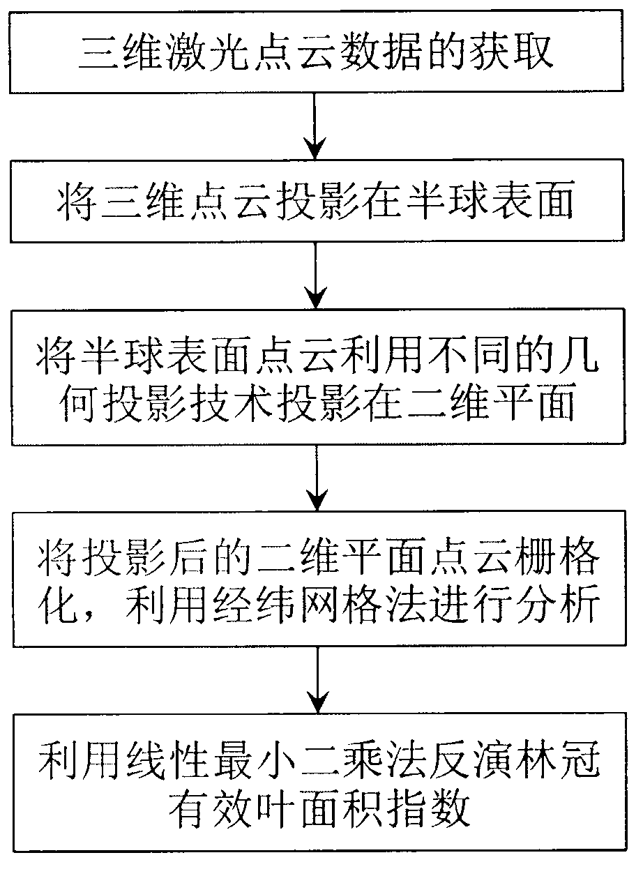
[0038]The present invention is further explained by example below:

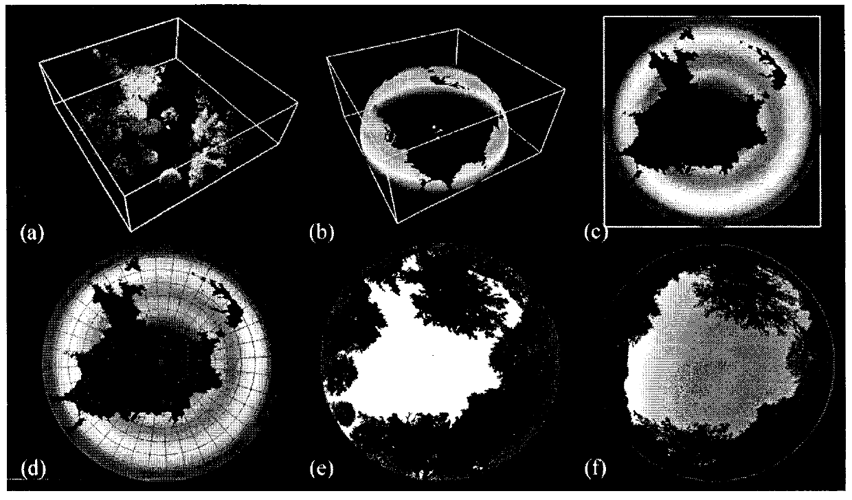
[0039] Taking a piece of Western Red Cedar (Western Red Cedar) as the research object (area about 50m*50m, tree height about 15m), using the ground three-dimensional laser scanner Leica ScanStation 2 (its parameters are shown in Table 1) and high-precision GPS, in The center of the quadrat was scanned in a hemispherical manner, the height of the scanner from the ground was 1 meter, and the sampling distance was 2 cm. Manually remove the ground point cloud and other noise point clouds to obtain the 3D point cloud data of the forest quadrat, as shown in the attached image 3 Shown in a.

[0040] Table 1 Parameters of 3D laser scanner Leica ScanStation2

[0041]

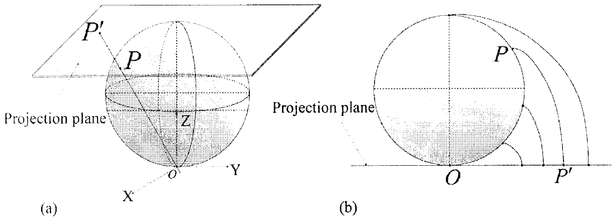
[0042] After obtaining the point cloud data of Douglas pine and preprocessing, as attached image 3 As shown, the geometric projection technology is used to process the 3D point cloud data. The first step is to project onto the surface of the hem...


PUM


Abstract

The invention provides a method for inverting effective leaf area index by utilizing geometric projection and laser radar and belongs to the field of research on methods for acquiring forest canopy structure parameter. The method includes the following steps: acquiring and preprocessing three-dimensional laser point cloud data of a plant canopy layer, converting a coordinate system of point cloud data, utilizing different geometric projections to project the three-dimensional point cloud data into a two-dimensional plane space and convert the data into a grid image and further utilizing the linear least square inversion algorithm to conduct estimation of porosity and effective leaf area index. Compared with a traditional observation method, the method is small in work amount and free of contact type observation and damage to the canopy structure and radiative characteristics, has the advantages of being objective, high in efficiency and accurate. A method for extracting three-dimensional structure and biological physical diversity information from laser radar data is developed, and characterization is conducted on the horizontal and vertical distribution change rule of leaves.

Description

1. Technical field [0001] The invention relates to a method for calculating the effective leaf area index of the forest canopy by using the point cloud data obtained by the ground three-dimensional laser scanner, specifically, it refers to an improved calculation geometric projection algorithm to calculate the effective leaf area index of the three-dimensional forest canopy. The method of area index (the process is as attached figure 1 shown). 2. Background technology [0002] The carbon and water cycles are two very important components in the biogeochemical process of global climate change. Leaf area index is an important input parameter for remote sensing-driven carbon-water coupled ecological process models. Leaf area can affect the microclimate of the canopy, determine the radiation use efficiency of the ecosystem, and control the flux of carbon, water and energy between the atmosphere-vegetation-soil. The development of remote sensing technology enables us to estima...

Claims


Application Information

Patent Timeline
Patent Type & Authority Applications(China)
IPC IPC(8): G01B11/28
Inventor 郑光冯永康张乾
Owner NANJING UNIV
Why Eureka
Try Eureka