Land subsidence monitoring and early warning system based on global position system (GPS) and hydrostatic leveling

A technology of static leveling and land subsidence, applied in height/level measurement, measuring device, surveying and mapping, and navigation, etc., can solve problems such as inaccurate measurement, achieve strong real-time performance and reduce engineering costs.

Active Publication Date: 2013-08-07
CHONGQING INST OF GREEN & INTELLIGENT TECH CHINESE ACADEMY OF SCI
View PDF5 Cites 34 Cited by
  • Summary
  • Abstract
  • Description
  • Claims
  • Application Information

AI Technical Summary

Problems solved by technology

[0006] In view of this, the purpose of the present invention is to provide a ground subsidence monitoring and early warning system based on GPS and static leveling, which can solve the problem of subsidence of the monitoring point after the settlement of the reference point without a stable reference po

Method used


Image

  • Land subsidence monitoring and early warning system based on global position system (GPS) and hydrostatic leveling

Examples


Embodiment Construction

[0019] The preferred embodiments of the present invention will be described in detail below with reference to the accompanying drawings.

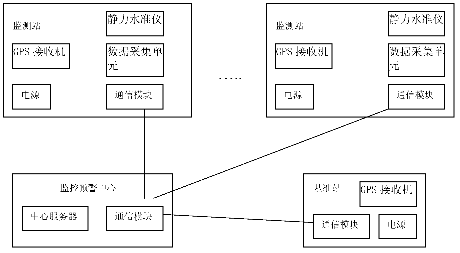
[0020] figure 1 It is a system structure diagram of the present invention, as shown in the figure, the ground subsidence monitoring and early warning system based on GPS and static leveling of the present invention includes: distributed and arranged in monitoring stations for monitoring ground subsidence in the area to be monitored; setting In the geologically stable area outside the area to be monitored, it is used to provide the reference station for the starting position of the reference and the monitoring and early warning center for analysis and early warning; each monitoring station includes a GPS receiver, a static leveling system, a communication module and a power supply. The force level system includes a static level and a data acquisition unit; the reference station includes a GPS receiver, a communication module and a power supp...


PUM


Abstract

The invention discloses a land subsidence monitoring and early warning system based on global position system (GPS) and hydrostatic leveling and belongs to the field of geological disaster monitoring and early warning. The system comprises a monitoring station, a base station and a monitoring and early warning center which are distributed, wherein a GPS receiver in the monitoring station and a datum point in a hydrostatic leveling system are mounted on a same observation pillar; the GPS receiver transmits received satellite observation data to the monitoring and early warning center; a data acquisition unit acquires monitoring data of a hydrostatic leveling instrument and transmits the data to the monitoring and early warning center; the GPS receiver in the base station receives the satellite observation data of a stable area point of the base station and transmits the data to the monitoring and early warning center; and the monitoring and early warning center receives the information transmitted by the monitoring station and the base station and processes and analyzes the data. According to the system, the problem that the monitoring point subsidence amount is inaccurate in measurement after a stable datum point is unavailable or the datum point is subsided in a measuring process of the hydrostatic leveling system can be solved, and a high-precision land subsidence value is acquired in real time.

Description

technical field [0001] The invention belongs to the technical field of geological disaster monitoring and early warning, and relates to a ground subsidence monitoring and early warning system based on GPS and static leveling. Background technique [0002] Land subsidence, also known as ground subsidence or ground subsidence, is defined as "slowly varying geological disasters" in China's "Regulations on the Prevention and Control of Geological Hazards". It is a local downward movement (or engineering geological phenomenon) that reduces the elevation of the crustal surface due to the consolidation and compression of the underground loose strata under the influence of natural and human engineering economic activities. The natural factors causing land subsidence are the tectonic movement of the earth's crust and the natural compaction of the surface soil. Land subsidence caused by human factors is widely seen in some large cities and oil, coal or natural gas mining areas where ...

Claims


Application Information

Patent Timeline
IPC IPC(8): G01C5/00
Inventor 刘刚刘曙光刘军
Owner CHONGQING INST OF GREEN & INTELLIGENT TECH CHINESE ACADEMY OF SCI
Why Eureka
Try Eureka