

Sorting method of vehicle-mounted laser scanning point cloud data of urban ground objects
A vehicle-mounted laser scanning and point cloud data technology, which is applied in the direction of electrical digital data processing, special data processing applications, electromagnetic wave re-radiation, etc., can solve the problems of low degree of self-adaptation and the inability to classify cloud data, and improve self-adaptation degree of effect
- Summary
- Abstract
- Description
- Claims
- Application Information
AI Technical Summary
Problems solved by technology
Method used
Image

Examples
Embodiment Construction
[0040] The technical solution of the present invention can adopt computer software technology to realize the automatic operation process. In order to facilitate those skilled in the art to understand and implement the present invention, the present invention will be further described in detail below in conjunction with the accompanying drawings and embodiments.
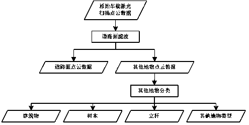
[0041] refer to figure 1 , an embodiment of the present invention provides a method for classifying urban features of vehicle-mounted laser scanning point cloud data, including:
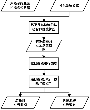
[0042] Step 1. Combining with the driving track data, perform road surface filtering on the original vehicle laser scanning point cloud data, and separate the road surface point cloud data from other object point cloud data;
[0043] In step 2, the point cloud data of other features obtained in step 1 after excluding the point cloud data of the road surface are further identified as different types of features such as buildings, poles, trees ...
PUM
 Abstract
Description
Claims
Application Information