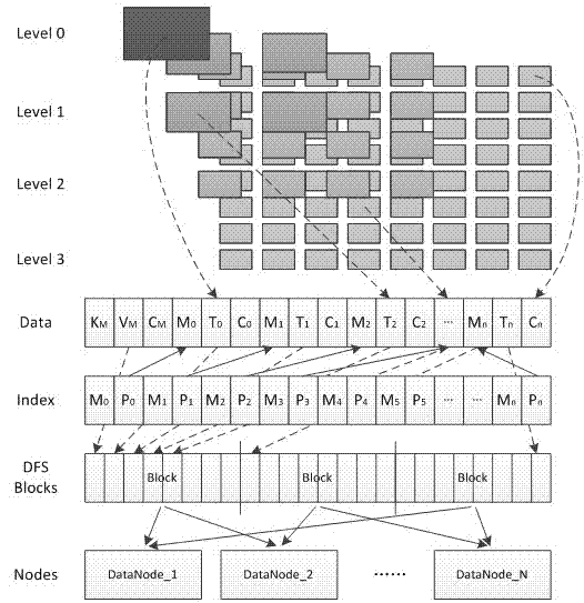
Remote sensing data cloud storage method based on image block organization
A technology of image data and remote sensing data, which is applied in the cross-field of distributed storage and geographic information science, can solve the problem of unfavorable image data block and small file storage, and achieve saving network bandwidth and data download time, high data throughput rate, high The effect of usability
- Summary
- Abstract
- Description
- Claims
- Application Information
AI Technical Summary
Problems solved by technology
Method used
Image
Examples
Embodiment
[0070] The implementation process of the remote sensing data cloud storage method based on image block organization includes three parts: uniform encoding of image data blocks, image data distributed storage model, and image data access.
[0071] 1. Remote sensing image data block unified coding method
[0072] Usually, the encoding using the Hilbert curve can better maintain the adjacency relationship between the image data blocks. This encoding method enables the adjacent image data blocks in the two-dimensional space to be placed as far as possible in the one-dimensional linear space. Adjacent positions, so that the physical storage of the image data block also maintains its spatial position characteristics. However, only using this encoding method to encode the image blocks of each layer separately will lead to repetition of encoding between different layers, making the encoding not unique.
[0073] In order to ensure the uniqueness of the coding of image data blocks in e...
PUM
 Abstract
Description
Claims
Application Information
 - R&D
- Intellectual Property
- Life Sciences
- Materials
- Tech Scout
- Unparalleled Data Quality
- Higher Quality Content
- 60% Fewer Hallucinations
Browse by: Latest US Patents, China's latest patents, Technical Efficacy Thesaurus, Application Domain, Technology Topic, Popular Technical Reports.
© 2025 PatSnap. All rights reserved.Legal|Privacy policy|Modern Slavery Act Transparency Statement|Sitemap|About US| Contact US: help@patsnap.com


