Land surface temperature-vegetation index feature space dry and wet limit selecting method and device

A technology of vegetation index and surface temperature, applied in the direction of electrical digital data processing, special data processing applications, material inspection products, etc., can solve the problems of deviation of dry and wet limits from the real situation, and the influence of false "wet points"

Inactive Publication Date: 2014-05-14
INST OF GEOGRAPHICAL SCI & NATURAL RESOURCE RES CAS
View PDF3 Cites 18 Cited by
  • Summary
  • Abstract
  • Description
  • Claims
  • Application Information

AI Technical Summary

Problems solved by technology

These so-called "false" dry points and "false" wet points will significantly affect the results of this general linear regression method , making the final selected dry and wet limits seriously deviate from the real situation
In short, this general linear fitting method has the disadvantage of being susceptible to "false" dry points and "false" wet points in the selection of dry and wet limits in the feature space

Method used


Image

  • Land surface temperature-vegetation index feature space dry and wet limit selecting method and device
  • Land surface temperature-vegetation index feature space dry and wet limit selecting method and device
  • Land surface temperature-vegetation index feature space dry and wet limit selecting method and device

Examples


Embodiment 1

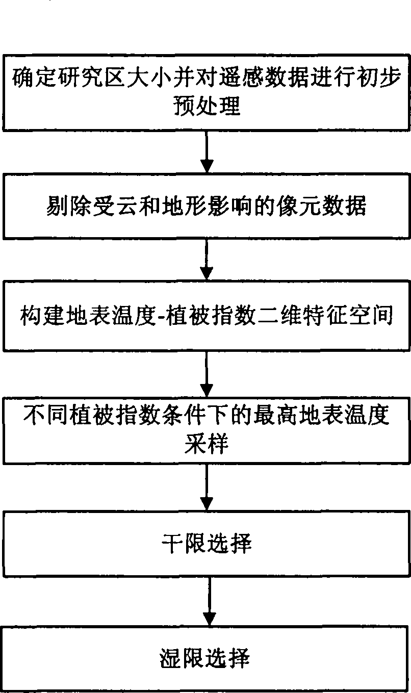
[0082] This example takes the remote sensing inversion of surface evapotranspiration as an example, as figure 1 Shown, the concrete implementation method of the present invention is as follows:

[0083] 1. Determine the size of the study area and the spatial resolution of the pixels, and initially construct the input data set of the surface temperature-vegetation index feature space. The surface temperature-vegetation index feature space is the surface temperature and vegetation index feature space.

[0084] The size of the study area should be set as far as possible to meet the condition that the relative soil moisture content and vegetation coverage of the surface layer have a full range of variation (0-1), and at the same time, it is necessary to ensure that the atmospheric forcing within the space is similar. Since the spatial resolution of satellite remote sensing thermal infrared band data is lower than that of visible light and near-infrared bands, in order to ensure th...

Embodiment 2

[0115] On the basis of the above examples, if Figure 5 As shown, the steps for estimating regional evapotranspiration using the dry and wet limit selection method of the surface temperature-vegetation index characteristic space of the present invention are:

[0116] After completing the steps 1-4 above, the following steps should be carried out when estimating regional evapotranspiration:

[0117] 5. Estimate the evaporation ratio pixel by pixel in the feature space.

[0118] The evaporation ratio (EF) per pixel in the feature space is calculated by the following formula:

[0119] EF = φ Δ Δ + γ

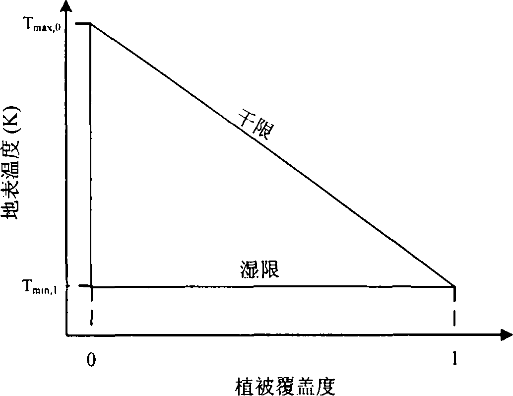
[0120] Among them, γ is the hygrometer constant, 0.066kPa / ℃; Δ is the slope of the temperature-saturated water vapor pressure curve; φ is a comprehensive parameter. For feature spaces (such as figure 2 Shown) Any pixel i(VI, T a ) value of φ:

[0121] ...


PUM


Abstract

The invention provides a land surface temperature-vegetation index feature space dry and wet limit selecting method and device. The method includes the steps of firstly, determining the size of a research area, and performing pretreatments such as projection conversion, resampling and cutting on satellite remote sensing image data; secondly, removing image metadata influenced by cloud and terrain; thirdly, using the rest image metadata to build a land surface temperature-vegetation index two-dimensional scatter diagram feature space; fourthly, sampling the highest land surface temperature corresponding to different vegetation index conditions obtained in the third step; fifthly, linear fitting the highest land surface temperature and vegetation indexes to obtain the dry limit of the feature space through threshold setting and an iteration algorithm; presuming that the wet limit temperature is a constant and equals to the dry limit temperature at the total vegetation cover to obtain the wet limit temperature. By the arrangement, the problems that the current land surface temperature-vegetation index feature space dry and wet limit selecting is high in subjective randomness and uncertainty, and the like are solved.

Description

technical field [0001] The invention belongs to the technical field of remote sensing inversion of evapotranspiration or soil moisture, and in particular relates to a method and a device for effectively selecting dry and wet limits of a surface temperature-vegetation index characteristic space. Background technique [0002] Surface evapotranspiration and soil moisture are key elements of the water cycle, which determine the water and heat transfer in the soil-vegetation-atmosphere system. Their quantitative estimation is the basis for evaluating terrestrial ecosystem productivity, regional water consumption, crop yield, and land use / land planning. It is also an important content of global or regional climate change research. The development of remote sensing evapotranspiration and soil moisture estimation methods based on remote sensing inversible parameters has become an important research direction in the field of quantitative remote sensing. Under the conditions of full-...

Claims


Application Information

Patent Timeline
Patent Type & Authority Applications(China)
IPC IPC(8): G06F19/00G01N33/24
Inventor 唐荣林李召良唐伯惠吴骅
Owner INST OF GEOGRAPHICAL SCI & NATURAL RESOURCE RES CAS
Why Eureka
Try Eureka