High-precision positioning and navigation system

A positioning and navigation, high-precision technology, applied in the field of vehicle navigation, can solve the problems of high cost of system implementation, system missed or false alarms, monitoring blind spots, etc., to expand the type and range of distance measurement, improve distance measurement accuracy, and reliable positioning sex high effect

Inactive Publication Date: 2015-04-08
福建爱特点信息科技有限公司
View PDF5 Cites 7 Cited by
  • Summary
  • Abstract
  • Description
  • Claims
  • Application Information

AI Technical Summary

Problems solved by technology

[0003] However, in the prior art, no matter whether the GPS module or the Beidou positioning and navigation module is used, the GPS signal fading is very large or the GPS signal cannot be received, the function of positioning and navigation will not be realized; when the number of GPS received is small, It will also lead to inaccurate positioning data, and there are problems such as random deviations, that is, in the prior art, no matter whether the positioning and navigation system adopts the GPS module or the Beidou positioning and navigation module, there is a problem of positioning blind spots.
[0004] With the wide application of gyroscopes, in order to solve the problem of positioning blind spots in existing positioning and navigation systems, various vehicle positioning monitoring and navigation systems based on gyroscope inertial navigation, or GPS/...

Method used


Image

  • High-precision positioning and navigation system
  • High-precision positioning and navigation system
  • High-precision positioning and navigation system

Examples


Embodiment approach

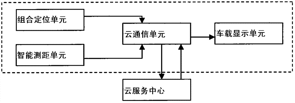
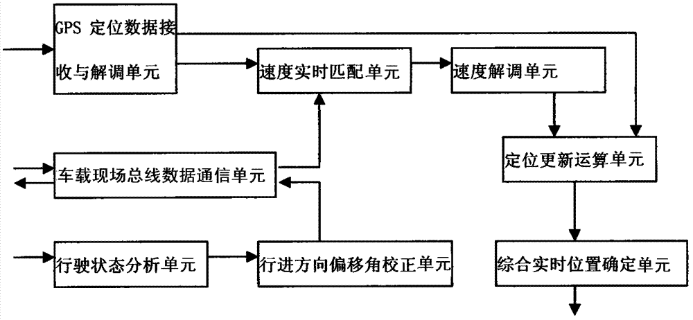
[0073] According to an embodiment of the present invention, the specific implementation process of the combined positioning unit includes the following steps:

[0074] S1, read from the GPS positioning module to obtain the current position information of the vehicle, the current positioning state, the current first vehicle speed parameter and the current moment, and the current position information of the vehicle includes longitude, latitude and direction of travel;

[0075] Acquiring the current second vehicle speed parameter of the external reference provided by the cloud communication unit;

[0076] Demodulate the current third vehicle speed parameter from the vehicle-mounted field bus network message;

[0077] S2. Through the speed real-time matching algorithm, the above three vehicle speed parameters are synthesized, and a minimum speed value of the error of the current state of the vehicle is calculated;

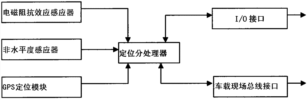
[0078] S3. Obtain the three-dimensional geomagnetic vector param...


PUM

PropertyMeasurementUnit
Loss factoraaaaaaaaaa

Abstract

The invention discloses a high-precision positioning and navigation system, which comprises a combined positioning unit, an intelligent ranging unit, a cloud communication unit and a vehicle-mounted display unit, wherein the combined positioning unit is used for realizing real-time positioning of the vehicle; the intelligent ranging unit is used for realizing calculation on the distance between the vehicle and a surrounding target; and the cloud communication unit is used for receiving data generated by the combined positioning unit and the intelligent ranging unit and uploading the data to a cloud service center, the cloud service center carries out map labeling on navigation positioning data, and the labeling information is issued to the vehicle-mounted display unit. The system of the invention is based on multi-parameter integrated processing, positioning data of the current dead zone can be effectively corrected and supplemented, errors of ultrahigh frequency microwave ranging can be effectively reduced, ranging types and the ranging range can be expanded, the ranging precision is improved, positioning reliability is high, and the maintenance cost is low.

Description

technical field [0001] The invention relates to the field of vehicle navigation, in particular to a high-precision positioning navigation system. Background technique [0002] Today's car positioning monitoring and navigation system, its core components usually include: positioning module (using GPS module or Beidou positioning module), data communication module (using GPRS or 3G) and data processing module and system platform. Moreover, the positioning module is indispensable in almost all vehicle positioning monitoring and navigation systems at present. The positioning module is the most basic source of location data. [0003] However, in the prior art, no matter whether the GPS module or the Beidou positioning and navigation module is used, the GPS signal fading is very large or the GPS signal cannot be received, the function of positioning and navigation will not be realized; when the number of GPS received is small, It will also lead to inaccurate positioning data, an...

Claims


Application Information

Patent Timeline
IPC IPC(8): G01S19/45
CPCG01C21/08G01S13/08G01S19/40G01S19/48G01S19/52
Inventor 李青花
Owner 福建爱特点信息科技有限公司
Why Eureka
Try Eureka