Processing method for detecting clouds on sea by polar orbit meteorological satellite visible and infrared radiometer (VIRR)

A meteorological satellite and processing method technology, applied in the field of meteorological remote sensing, can solve problems such as difficulty in reaching, radiation transfer mode error, and difficulty in meeting users' concerns about sea temperature product quality, etc., and achieve the effect of improving accuracy

Inactive Publication Date: 2015-08-05
NAT SATELLITE METEOROLOGICAL CENT
View PDF8 Cites 16 Cited by
  • Summary
  • Abstract
  • Description
  • Claims
  • Application Information

AI Technical Summary

Problems solved by technology

Among them, the dynamic threshold method selects 450 × 2048 pixel blocks for underlying surface distinction and histogram statistics, and 450 × 2048 pixel blocks are likely to cause discontinuity in cloud detection results between blocks (see attached Figure 4 shown)
The method of determining the threshold value of the radiative transfer mode requires the remote sensing instrument to have an ideal spectral response curve, and requires the atmospheric profile to correctly represent the state of the atmosphere, which is difficult to achieve in practice, and the radiative transfer model itself also has errors
At present, the cloud detection products of the Fengyun-3 meteorological satellite VIRR business system have missed cloud judgments on the ocean (see attached Figure 4 C area), especially at night, cloud pollution will seriously affect the accuracy of sea temperature retrieval, it is difficult to meet the user's increasing demand for sea temperature product quality

Method used


Image

  • Processing method for detecting clouds on sea by polar orbit meteorological satellite visible and infrared radiometer (VIRR)
  • Processing method for detecting clouds on sea by polar orbit meteorological satellite visible and infrared radiometer (VIRR)
  • Processing method for detecting clouds on sea by polar orbit meteorological satellite visible and infrared radiometer (VIRR)

Examples


Embodiment 1

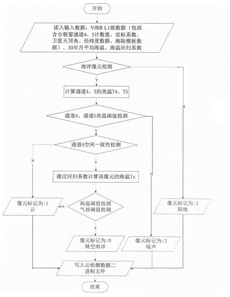
[0034] As a kind of realization mode of the object of the present invention, such as figure 2 Shown is a schematic flow chart of a processing method for detecting clouds on the ocean by a polar-orbiting meteorological satellite VIRR, and the processing process is as follows:

[0035] 1) Read FY3B / VIRR L1B data;

[0036] The data is in HDF5 format, which contains the count value of channel 4 and channel 5 of the split window, calibration coefficient, satellite zenith angle, longitude and latitude data, sea and land template data, etc.;

[0037] 2) Read the 30-year monthly average sea temperature data;

[0038] 3) Read sea temperature regression coefficients a0~a3;

[0039] The regression coefficient is calculated based on the FY3B / VIRR long-term satellite observation data and the buoy matching data set. The matching window of 1.1 kilometers above and 1 hour above the time is matched. The pixel that meets the clear sky ocean and the above matching conditions is a matching sa...


PUM


Abstract

The invention relates to a processing method for detecting clouds on sea by polar orbit meteorological satellite visible and infrared radiometer (VIRR), which belongs to the field of meteorological remote sensing technology. According to the processing method, firstly first-grade observation data of the polar orbit meteorological satellite visible and infrared radiometer (VIRR) after positioning and scaling and corresponding sea-and-land template information are identified, thereby obtaining sea observation data; for sea image elements, information such as split window brightness temperature, brightness temperature difference, satellite zenith angle and sea temperature regression coefficient is used for performing sea surface temperature inversion; according to the characteristic of the VIRR instrument, statistical analysis is performed based on a matching data set of a long time sequence, and a temperature threshold is set; when the observed brightness temperature and the inversed sea temperature or the inversed sea temperature and the climatic sea temperature of the sea image element exceed a preset threshold, a fact that the sea image element is the image element with a cloud is determined. Compared with the prior art, the temperature threshold is set by means of the clinic change rule of the sea surface temperature and long-time sequence statistical information of the satellite detecting instrument VIRR; quantitative calculation or judgment for cloudy or sunny is performed on a target; and accuracy for detecting the clouds on the sea is improved.

Description

technical field [0001] The invention relates to a processing method for detecting clouds on the ocean, in particular to a processing method for detecting clouds on the ocean by a visible light infrared scanning radiometer (VIRR) of a polar-orbiting meteorological satellite, and belongs to the technical field of meteorological remote sensing. Background technique [0002] Fengyun-3 meteorological satellite is China's second-generation Fengyun polar-orbiting meteorological satellite. The visible infrared scanning radiometer (VIRR) mounted on the satellite has a spectral range of 0.43-12.5μm, 10 channels, and a ground horizontal resolution of 1.1Km. VIRR has one short-wave infrared channel (3.55-3.93 μm), and two long-wave infrared channels, split window channels (10.3-11.3 μm and 11.5-12.5 μm), which can be used to estimate sea surface temperature. The shortwave infrared channel calibration is affected by solar pollution at night (solar zenith angle between 85° and 118°), so i...

Claims


Application Information

Patent Timeline
Patent Type & Authority Applications(China)
IPC IPC(8): G01W1/06
CPCG01W1/06
Inventor 王素娟崔鹏张鹏陆风冉茂农王维和
Owner NAT SATELLITE METEOROLOGICAL CENT
Why Eureka
Try Eureka