Lightweight satellite data distributed collaborative service system based on opensearch

A satellite data and collaborative service technology, applied in the field of satellite data distributed system services, can solve the problems of long integration period, complex communication protocols, and high coupling of communication protocols, and achieve a shortened integration period, high construction efficiency, and simple system structure. Effect

Active Publication Date: 2018-07-06
INST OF REMOTE SENSING & DIGITAL EARTH CHINESE ACADEMY OF SCI
View PDF3 Cites 0 Cited by
  • Summary
  • Abstract
  • Description
  • Claims
  • Application Information

AI Technical Summary

Problems solved by technology

[0030] Inconsistent standards: Data sharing platforms have their own data grid system data description standards and data release sharing protocols, etc. These standards and protocols are severely coupled with their own systems, making it difficult to directly transplant to other data service systems
This makes it difficult to realize the system of systems (system of systems), making each data sharing platform an island of data
[0031] Communication protocol coupling is too high: Even if the data grid system of OGC (Open GIS Consortium) is adopted at present, the data exchange protocol and data interoperability protocol used are seriously coupled to the system, when other existing services When the data unit of the system wants to join the grid system, the integration cycle is often longer, the efficiency is low, and it is difficult to guarantee the independence and autonomy of the data unit
[0032] The communication protocol is too complicated: When an emergency needs to quickly build a spatial data grid and realize heterogeneous spatial data sharing to provide decision support, the efficiency of the existing data sharing technology to build a spatial data sharing platform is too low, and the grid system is automated. The lack of rapid construction technology makes it difficult to realize rapid information sharing in emergencies with heterogeneous data sources
[0033] Lack of reliable security mechanism: When a certain data sharing system is connected to the grid, its own security mechanism is easily destroyed

Method used


Image

  • Lightweight satellite data distributed collaborative service system based on opensearch
  • Lightweight satellite data distributed collaborative service system based on opensearch
  • Lightweight satellite data distributed collaborative service system based on opensearch

Examples


Embodiment Construction

[0079] The following will clearly and completely describe the technical solutions in the embodiments of the present invention with reference to the accompanying drawings in the embodiments of the present invention. Obviously, the described embodiments are only some, not all, embodiments of the present invention. All other embodiments obtained by persons of ordinary skill in the art based on the embodiments of the present invention belong to the protection scope of the present invention.

[0080] According to an embodiment of the present invention, an OpenSearch-based lightweight satellite data distributed collaborative service system is provided.

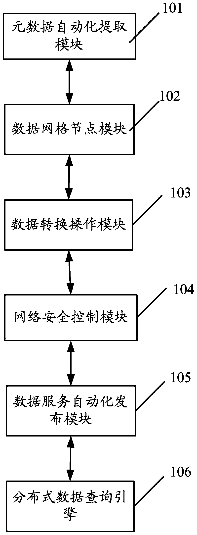
[0081] like figure 1 As shown, a kind of distributed collaborative service system based on OpenSearch lightweight satellite data according to the embodiment of the present invention includes:

[0082] The metadata automatic extraction module 101 is used to automatically extract the remote sensing data metadata of each satellite dat...


PUM


Abstract

The present invention discloses an OpenSearch based distributed cooperative service system for lightweight satellite data. The system comprises: a metadata automated extraction module, used for automatically extracting metadata of remote sensing data and constructing a meta database; a data grid node module, used for implementing calling for a business process of data query, data acquisition and data cataloging synchronization service as well as packaging and management of the data; a data conversion operation module, used for performing conversion on a data source of an OpenSearch service, a data source parameter of a non-OpenSearch service and an interoperability protocol; a network security control module, used for setting and managing rights of a user and a data request initiated by the user according to a security policy; a data service automated publishing module, used for externally providing an OpenSearch service interface and a non-OpenSearch service interface; and a distributed data query engine, used for implementing distributed query of a distributed heterogeneous data source.

Description

technical field [0001] The invention relates to a satellite data distributed system service technology, in particular to a lightweight satellite data distributed collaborative service system based on OpenSearch. Background technique [0002] 1. Spatial data grid system based on Web Service: [0003] Web Service technology enables different applications running on different machines to exchange data or integrate without additional, specialized third-party software or hardware. Applications implemented according to the Web Service specification can exchange data with each other regardless of the language, platform or internal protocol they use. Web Service is a self-describing and self-contained available network module that can perform specific business functions. Web Services are also easy to deploy, because they are based on some conventional industry standards and some existing technologies, such as subset XML and HTTP under the standard common markup language. Web Serv...

Claims


Application Information

Patent Timeline
Patent Type & Authority Patents(China)
IPC IPC(8): G06F17/30
CPCG06F16/27
Inventor 庞禄申李国庆解吉波于文洋黄克颖张红月张连翀刘莉苹
Owner INST OF REMOTE SENSING & DIGITAL EARTH CHINESE ACADEMY OF SCI
Why Eureka
Try Eureka