Method for reconstructing large-scale complex flyover 3D model by using airborne LiDAR data

A three-dimensional model and data reconstruction technology, applied in image data processing, instruments, calculations, etc., can solve problems such as overpass occlusion, and achieve the effect of improving quality, improving reconstruction efficiency and accuracy, and reducing technical difficulty

Inactive Publication Date: 2016-07-20
NANJING UNIV +1
View PDF3 Cites 23 Cited by
  • Summary
  • Abstract
  • Description
  • Claims
  • Application Information

AI Technical Summary

Problems solved by technology

[0006] The technical problem to be solved by the present invention is: to overcome the shortcomings of the prior art, and to propose a method for reconstructing a three-dimensional model of a large and complex overpass using airborne LiDAR data, which can solve the problem of overpass occlusion, and accurately and efficiently reconstruct a three-dimensional model of a large and complex overpass

Method used


Image

  • Method for reconstructing large-scale complex flyover 3D model by using airborne LiDAR data
  • Method for reconstructing large-scale complex flyover 3D model by using airborne LiDAR data
  • Method for reconstructing large-scale complex flyover 3D model by using airborne LiDAR data

Examples


Embodiment Construction
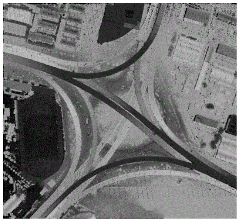
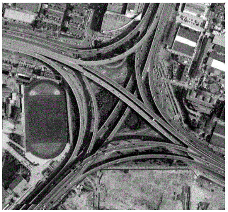
[0066] The embodiment area of ​​the present invention is an overpass bridge in Jiangsu Province. Airborne LiDAR raw data ( Figure 2-a ), as the example data for reconstructing a 3D model of a large complex overpass, the average point spacing is 1m, the elevation accuracy is 0.20m, and the plane accuracy is 0.50m. The size of the embodiment area is about 520m×450m, and the original data has a total of 820,000 scanning points. High resolution image data ( Figure 2-b ), as the reference data for model evaluation, the image resolution is 0.10m.

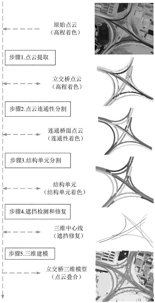
[0067] Embodiments of the present invention utilize airborne LiDAR data to reconstruct a large-scale and complex overpass three-dimensional model method (see the overall process figure 1 ), including the following steps:

[0068] Step 1. Extract the overpass point cloud. Firstly, the overpass point cloud needs to be extracted from the raw LiDAR data. The original data mainly contains four types of point clouds: overpasses, buildin...


PUM


Abstract

The invention relates to a method for reconstructing a large-scale complex flyover 3D model by using airborne LiDAR data. The method includes the following steps: using inverse iteration mathematic morphological filtering and area information to extract flyover point cloud from airborne LiDAR data; in accordance with bridge floor connectivity, segmenting the flyover cloud point; adopting a central line vertical line scanning method to segment and extract a communicated bridge surface which has no bifurcation or intersection structures and has a width consistent width, acquiring a "constitutional unit"; an end place of the constitutional unit central line serving as a circular buffer area, detecting a shielding structure of the flyover through determination of point cloud height information within the buffer area; through steps of constitutional unit matching, 2D central line fitting and 3D curved surface fitting, acquiring a complete bridge surface 3D central line; and reconstructing a flyover 3D model in combination with bridge surface width information. Practice has proved that the method of the invention can effectively reconstruct the large-scale complex flyover 3D model, addresses shielding problem of the flyover point cloud, and the reconstructed 3D model has a higher correctness and completeness.

Description

technical field [0001] The invention relates to a method for reconstructing a three-dimensional model of an overpass, in particular to a method for reconstructing a three-dimensional model of a large complex overpass by using airborne LiDAR data. Background technique [0002] The overpass makes urban traffic from plane to three-dimensional, avoids traffic conflicts at intersections, can not only ensure the driving safety of vehicles, but also improve the traffic capacity of roads, and also has strong traffic management functions. As a new three-dimensional road node, the overpass has become a landmark building in a modern city, and it is also an indispensable part of urban landscape design and image promotion. The 3D model of the overpass can present complete spatial information, which is of great significance in the fields of traffic navigation, landscape design, and urban publicity. [0003] Large-scale overpasses are relatively complex multi-layered features, and their m...

Claims


Application Information

Patent Timeline
Patent Type & Authority Applications(China)
IPC IPC(8): G06T7/00
CPCG06T2207/10028G06T2207/10044G06T2207/30181
Inventor 程亮姜小俊伍阳李满春陈焱明王昱谌颂许浩王娅君袁一
Owner NANJING UNIV
Why Eureka
Try Eureka