Water tank three-dimensional topographic measurement device based on camera image processing technology

A three-dimensional terrain and image processing technology, applied in measurement devices, radio wave measurement systems, photogrammetry/video measurement, etc., can solve the problems of high cost, low reliability and low efficiency, and achieve low cost and reliability. high effect

Inactive Publication Date: 2016-08-17
CHANGSHA UNIVERSITY OF SCIENCE AND TECHNOLOGY
View PDF6 Cites 8 Cited by
  • Summary
  • Abstract
  • Description
  • Claims
  • Application Information

AI Technical Summary

Problems solved by technology

[0007] The purpose of the present invention is to provide a simple, reliable and fast three-dimensional terrain measurement device using camera and laser technology to

Method used


Image

  • Water tank three-dimensional topographic measurement device based on camera image processing technology
  • Water tank three-dimensional topographic measurement device based on camera image processing technology

Examples


Embodiment 1

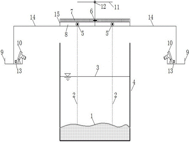
[0057] Embodiment 1: when this product of the present invention is used, the operation is simple and easy, and the specific implementation steps are as follows:

[0058] step 1): figure 1 First put the whole horizontal steel frame 15 above the center line of the water tank and fix it on the horizontal steel beam 11 with movable steel hinge 12;

[0059] Step (2): adjust the movable steel frame 15 to reach the level through the level gauge 6;

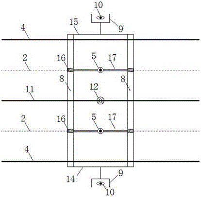
[0060] Step (3): Fix two lasers 5 in the middle of the horizontal steel frame 15, fix two cameras 10 in the hanging blue 9, and adjust the cameras 10 to be horizontal and coincide with the vertical marking line on the outer glass surface of the tank;

[0061] Step (4): Keep the water surface of the tank without obvious fluctuations, turn on the camera 10, move in the slot 8 through the roller 16, adjust the lateral position of the laser 5, and fix the two lasers 5 to the edges of the tank on both sides;

[0062] Step (5): Use the wirele...


PUM


Abstract

The invention discloses a water tank three-dimensional topographic measurement device based on a camera image processing technology and a measurement method based on the device. The device at least comprises two sets of photographing devices and two laser emission devices, and a uniform-speed movement device of the laser emission devices. The method comprises the following steps of: photographing a water tank sediment bed surface picture by the photographing device through a wireless remote control manner; then copying the photographed picture or a recorded video into a computer; and calculating by utilizing image processing software and a calculation procedure to obtain a three-dimensional bed surface topography. The water tank three-dimensional topographic measurement device is economical and practical, and the obtained three-dimensional topography has high reliability and precision; furthermore, the measurement of a bed surface two-dimensional topography in a video mode is changed along time; the topography is measured in a non-contact manner and the movement of water flow and sediment is not interfered; and the water tank three-dimensional topographic measurement device can also be used for measuring a river bed topography with middle sediment concentration and low sediment concentration, and an experiment does not need to be paused.

Description

technical field [0001] The invention relates to the technical field of water tank three-dimensional terrain measurement for environmental sediment experiments in hydraulic engineering, environmental engineering and marine engineering laboratories. Background technique [0002] In the experimental research of mass transport, river bed evolution, coastal sediment transport, debris flow movement, etc., it is necessary to accurately measure the underwater three-dimensional topographical changes in the experimental tank. At present, there are many methods for measuring the three-dimensional terrain changes in the tank, such as single-point probe method, photoelectric reflection, impedance topography, tracking topography, ultrasonic topography, laser scanner, etc. [0003] The single-point stylus measures the bed surface elevation through the reading of the stylus scale. The method is simple and easy to operate, but it is inefficient, labor-intensive, not real-time, and it is diff...

Claims


Application Information

Patent Timeline
IPC IPC(8): G01C11/00G01C11/36
CPCG01C11/00G01C11/36Y02A90/30
Inventor 李志威胡世雄李忠武胡旭跃陈宏常留红聂小宝余关龙吴新宇
Owner CHANGSHA UNIVERSITY OF SCIENCE AND TECHNOLOGY
Why Eureka
Try Eureka