Rainfall intensity mountain-based measurement method employing GNSS signal polarization phase shift

A technology of rainfall intensity and measurement method, applied in rainfall/precipitation meter, measurement device, meteorology, etc., can solve the problem of limited spatial resolution and temporal resolution, less research on the application of GNSS polarized signals, and unpublished research results and other problems, to achieve the effect of strong continuity, rich GNSS signal resources, equipment complexity and low cost

Active Publication Date: 2016-12-14
PLA UNIV OF SCI & TECH
View PDF4 Cites 2 Cited by
  • Summary
  • Abstract
  • Description
  • Claims
  • Application Information

AI Technical Summary

Problems solved by technology

However, at present, there are few studies on the application of GNSS polarimetric signals
In 2010, E. Cardellach et al. proposed the concept of using GNSS polarized occultation signals received by low-orbit satellites to detect heavy rainfall, but their key research result

Method used


Image

  • Rainfall intensity mountain-based measurement method employing GNSS signal polarization phase shift
  • Rainfall intensity mountain-based measurement method employing GNSS signal polarization phase shift
  • Rainfall intensity mountain-based measurement method employing GNSS signal polarization phase shift

Examples


Embodiment Construction

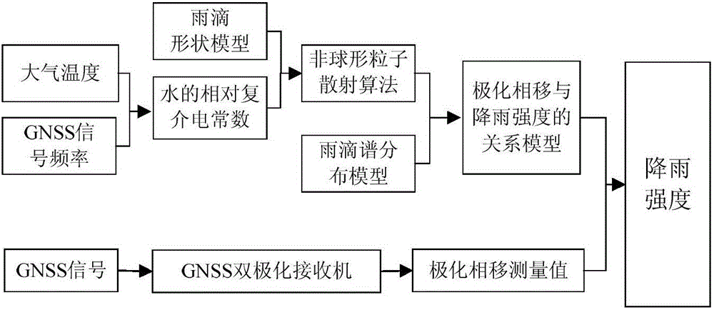
[0020] The present invention will be described in further detail below in conjunction with the accompanying drawings.

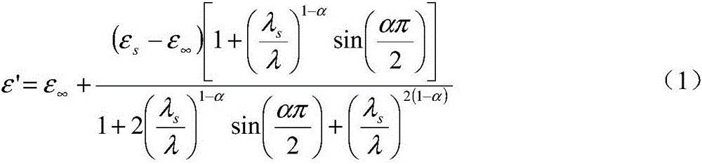
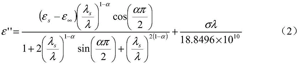
[0021] 1. Calculate the relative complex permittivity of water

[0022] Set up a GNSS dual-polarization receiver on the top of a mountain with a wide view, and there is no shelter in the antenna pointing direction, and can normally receive GNSS satellite signals within the range of 0-30° elevation angle and 80° viewing angle; then, use the receiver to collect through The forward scattering signal of the GNSS satellite behind the rainfall area, and use the frequency of the signal, combined with the atmospheric temperature at this time, and use the Ray formula to calculate the relative complex permittivity of water.

[0023] The Ray formula used is

[0024] ϵ ′ = ϵ ∞ + ( ϵ s - ...


PUM


Abstract

The invention discloses a rainfall intensity mountain-based measurement method employing GNSS signal polarization phase shift. The method comprises the steps: firstly determining an experiment place, setting up a GNSS double-polarization receiver, and collecting a GNSS signal; secondly calculating the relative complex dielectric constant of water corresponding to the signal; thirdly obtaining forward scattering polarization features according to a raindrop shape model and a Rayleigh scattering approximate non-spherical particle scattering algorithm after the signal is transmitted to a single raindrop with a different radius; fourthly obtaining the polarization phase shift of the signal because of path group raindrops and the mathematic relation between the polarization phase shift and the rainfall intensity through combining the raindrop spectrum distribution and a process that the signal passes through a rainfall region; and finally obtaining the rainfall intensity according to the actual measurement value of the polarization phase shift and the obtained mathematic relation. The method enlarges the application ranges of the GNSS signal, increases the ways for obtaining the rainfall intensity, and is a new method for the regional, real-time and passive measurement of the rainfall intensity.

Description

technical field [0001] The invention belongs to the technical field of atmospheric remote sensing and atmospheric detection, in particular to a method for obtaining rainfall intensity by utilizing the polarization phase shift generated by rainfall on air-ground link GNSS signals. Background technique [0002] In recent years, the global navigation satellite system (GNSS) including the GPS of the United States, the GLONASS of Russia, the GALILEO of the European Union under construction, and the Beidou satellite navigation system of my country have developed vigorously and their technologies have become increasingly mature. So far, my country has successfully launched 23 Beidou navigation satellites. With the advancement of technology, GNSS signals are not only used for navigation positioning and precise timing, but also its non-navigation applications have also developed rapidly, some of which have achieved commercial operation, and some have carried out many research experim...

Claims


Application Information

Patent Timeline
IPC IPC(8): G01W1/14
CPCG01W1/14Y02A90/10
Inventor 安豪黄云仙严卫王迎强王蕊李冠林胡申森戈书睿杜起飞白伟华
Owner PLA UNIV OF SCI & TECH
Why Eureka
Try Eureka