Land coverage change algorithm and system based on time-space analysis

A land cover, spatiotemporal analysis technology, applied in the field of spatial analysis, can solve problems such as unsatisfactory universality, difficulty in controlling endogenous noise, and the influence of land cover change detection algorithm results, so as to improve automation and monitoring accuracy and reduce influence. Effect

Inactive Publication Date: 2017-03-29
BEIJING AEROSPACE TITAN TECH CO LTD
View PDF3 Cites 29 Cited by
  • Summary
  • Abstract
  • Description
  • Claims
  • Application Information

AI Technical Summary

Problems solved by technology

[0004] The constant changes in conditions such as the sun's altitude angle, atmospheric radiation, and satellite sensor receiving angle have caused the remote sensing in the same area to be greatly affected by the above conditions in different periods.
The results of land cover change detection algorithms using remote sensing images of different time periods will also be affected
Although many scholars use different algorithms to correct remote sensing images, due to the lack...

Method used


Image

  • Land coverage change algorithm and system based on time-space analysis
  • Land coverage change algorithm and system based on time-space analysis
  • Land coverage change algorithm and system based on time-space analysis

Examples


Embodiment 1

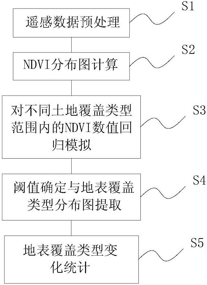
[0058] Please refer to figure 1 , in one embodiment of the present invention, the land cover change algorithm based on spatio-temporal analysis comprises the following steps:

[0059] S1: Remote sensing data preprocessing:

[0060] Corresponding the remote sensing image with the actual spatial position and characteristics of ground objects;

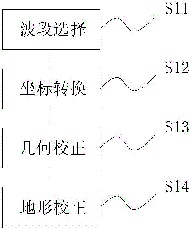
[0061] The remote sensing images in S1 may come from the same sensor images in different periods, or from different sensors in the same period, or from different sensors in different periods. Such as figure 2 As shown, in this embodiment, the correspondence between the remote sensing image and the actual spatial position and characteristics of the ground object may include the following sub-steps:

[0062] S11: Band selection

[0063] Remote sensing image combing software is used to extract the band used to calculate NDVI data; this band mainly includes the red band and near-infrared band of visible light in remote sensing images.

...

Embodiment 2

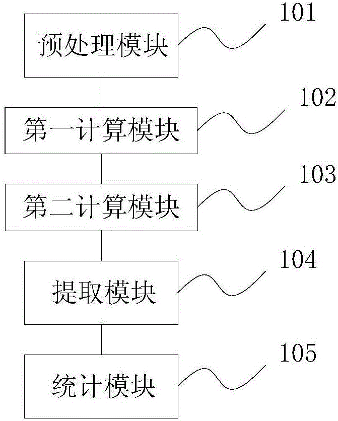
[0085] Please also refer to image 3 , this embodiment provides a land cover change calculation system based on spatio-temporal analysis, corresponding to the algorithm in Embodiment 1, specifically including

[0086] The preprocessing module 101 is used for remote sensing data preprocessing, that is, corresponding to the remote sensing image and the actual spatial position and characteristics of ground objects; the preprocessing module is specifically used for:

[0087] Band selection:

[0088] Using remote sensing image carding software to extract the bands used to calculate NDVI data;

[0089] Coordinate transformation:

[0090] Transform the spatial coordinates of remote sensing images of different time phases to form time series data of remote sensing images under the same coordinates;

[0091] Geometric Correction:

[0092] For the images of the same area obtained by different time bands and different sensor systems, establish the corresponding relationship between t...


PUM


Abstract

The invention discloses a land coverage change algorithm based on time-space analysis. The method comprises the following steps: S1, performing remote sensing data preprocessing; S2, performing NDVI distribution map calculation; S3, performing regression simulation on NDVI values in different land coverage type scopes; S4, performing threshold determining and land coverage type distribution map extraction; and S5, performing land coverage type change statistics. According to the invention, by taking remote sensing images of different time phases and land data (such as second national land data employed by the embodiments of the invention) of field investigation as a basis, image preprocessing is performed on the remote sensing images, and plantation normalization exponents of the different time phases are obtained. Model analyzing is performed on NDVI data of the different time phases and corresponding land field investigation data, an NDVI threshold scope corresponding to each type of land is determined, a quite clear land use type graph is obtained, and changing land coverage change data statistics is carried out.

Description

technical field [0001] The invention relates to the technical field of spatial analysis, in particular to a land cover change algorithm and system based on temporal and spatial analysis. Background technique [0002] Change detection mainly refers to observing the state of objects and phenomena in different periods, quantitative statistical analysis, and determining the characteristics and process of object changes. It involves the type of change, the amount of change, and determining the boundaries and trends before and after the change. Land cover change mainly refers to the state quantity of land cover type area and spatial distribution in different periods, the change type and change amount between land cover types in different periods, etc. [0003] In recent years, scholars at home and abroad have conducted research on land cover dynamic changes based on satellite remote sensing data. At present, the widely used methods mainly include difference comparison method bas...

Claims


Application Information

Patent Timeline
IPC IPC(8): G06K9/00G06K9/36G06T5/00G06T7/30
CPCG06T5/009G06T2207/30181G06T2207/10032G06T2207/10048G06V20/194G06V20/13G06V10/247G06V10/20
Inventor 谭靖李莹彭松段卫虎
Owner BEIJING AEROSPACE TITAN TECH CO LTD
Why Eureka
Try Eureka