Plant protection unmanned plane autonomous flight path optimization device and method

A plant protection drone and flight path technology, applied in the field of plant protection drones, can solve the problems that the aircraft cannot avoid in time, delay the aircraft too late to avoid, hidden dangers, etc., so as to reduce the repeated coverage rate, improve the accuracy and operation efficiency, The effect of reducing labor intensity

Pending Publication Date: 2017-07-04
NANJING UNIV OF INFORMATION SCI & TECH
View PDF4 Cites 27 Cited by
  • Summary
  • Abstract
  • Description
  • Claims
  • Application Information

AI Technical Summary

Problems solved by technology

Most of the technologies now use the ground station system to generate the flight trajectory of the drone, use GPS to analyze the latitude and longitude of the surrounding edge points, and record the data to the ground station system, the ground station generates multiple target points based on the data, and saves the points , to form the flight path of the aircraft. This method has certain limitations to the region, and when the terrain is uneven, that is, when there are obstacles, the aircraft may not be able to avoid it in time, and there are potential safety hazards
Now some plant protection machines are equipped with obstacle detectors for detecting obstacles around agricultural plant protection drones, but when encountering obstacles, the drone sends them to the ground station through digital transmission, and then receives emergency obstacle avoidance instructions This delay may make it too late for the aircraft to evade and cause danger

Method used


Image

  • Plant protection unmanned plane autonomous flight path optimization device and method
  • Plant protection unmanned plane autonomous flight path optimization device and method
  • Plant protection unmanned plane autonomous flight path optimization device and method

Examples


Embodiment Construction

[0035] The technical scheme of the present invention is described in detail below in conjunction with accompanying drawing:

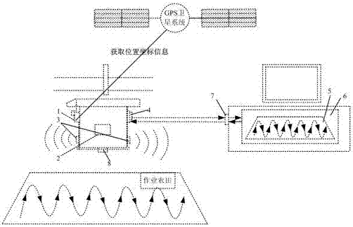
[0036] Such as figure 1 As shown, a plant protection UAV autonomous flight path optimization device, including:

[0037] Set on the plant protection drone for collecting the horizontal coordinates and height coordinates of the plant protection drone, and an airborne GPS antenna 1 communicating with the GPS satellite system;

[0038] A flight control system 2 set on the plant protection drone for controlling the flight and sowing operations of the plant protection drone;

[0039] The airborne relative height detector 3 that is arranged on the plant protection drone for detecting the height of the plant protection drone relative to the ground;

[0040] An airborne camera 8 set on the plant protection drone for aerial sampling of the farmland;

[0041] It is set on the plant protection UAV for returning the data obtained by the airborne GPS antenna 1, t...


PUM


Abstract

A plant protection unmanned plane autonomous flight path optimization device and method relate to the plant protection unmanned plane technology field. The device comprises an airborne GPS antenna, a flight control system, an airborne relative altitude detector, an airborne camera and an airborne data pass back and receiving system arranged on the plant protection unmanned plane, and a ground station geography information and image processing system, a ground station flight task program system and a ground station instruction receiving and transmission system located at a ground station. The plant protection unmanned plane autonomous flight path optimization device and method realize reasonable selection of paths according to different landforms so as to improve the unmanned plane work accuracy and work efficiency, reduce the repetition coverage rate, the spray leakage rate and energy consumption.

Description

technical field [0001] The invention relates to the technical field of plant protection drones. Background technique [0002] In recent years, with the continuous development and maturity of multi-rotor UAV technology, in terms of agricultural plant protection, the multi-rotor UAV operation method has greatly saved labor costs and improved operation efficiency compared with traditional manual operations. At the same time, it also ensures that operators are not harmed by pesticides; compared with traditional fixed-wing aircraft spraying large areas, multi-rotor UAV operations can significantly reduce flight costs. The downwash airflow generated by the rotating blades can blow away the leaves on the surface of the plants, so that the pesticides can be evenly applied to the whole crops, which effectively improves the application efficiency of pesticides and reflects the requirements of precision agriculture. Considering that the plant protection aircraft is operating in a larg...

Claims


Application Information

Patent Timeline
Patent Type & Authority Applications(China)
IPC IPC(8): G05D1/08G05D1/10
CPCG05D1/0808G05D1/101
Inventor 王伟刘建梅马茜许鑫乐
Owner NANJING UNIV OF INFORMATION SCI & TECH
Why Eureka
Try Eureka