Data fusion method suitable for positioning, navigating and time service microsystem

A technology of positioning and navigation and data fusion, applied in the field of integrated navigation, can solve the problems of difficult to meet real-time measurement, poor autonomy and reliability, application limitations, etc. Effect

Inactive Publication Date: 2017-09-01
NANJING UNIV OF SCI & TECH
View PDF3 Cites 23 Cited by
  • Summary
  • Abstract
  • Description
  • Claims
  • Application Information

AI Technical Summary

Problems solved by technology

However, the accuracy of the current miniature inertial sensor is still relatively low, resulting in certain restrictions on its application.
The global positioning system can provide full-time, global, and all-weather high-precision speed measurement and positioning services, but it has problems such as poor autonomy, reliability, and susceptibility to interference, so it is difficult to meet the requirements of real-time measurement

Method used


Image

  • Data fusion method suitable for positioning, navigating and time service microsystem
  • Data fusion method suitable for positioning, navigating and time service microsystem
  • Data fusion method suitable for positioning, navigating and time service microsystem

Examples


Embodiment Construction

[0016] The present invention will be described in further detail below in conjunction with the accompanying drawings and specific embodiments.

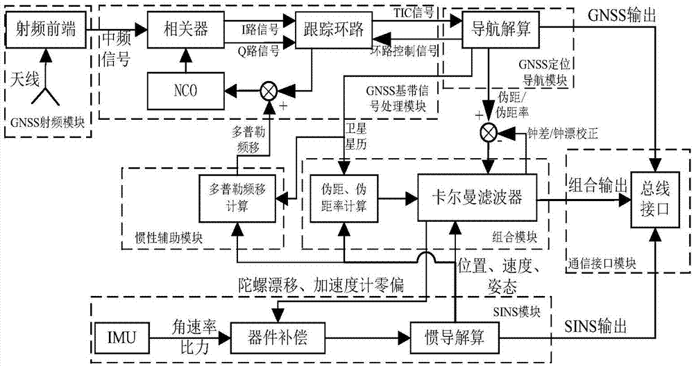
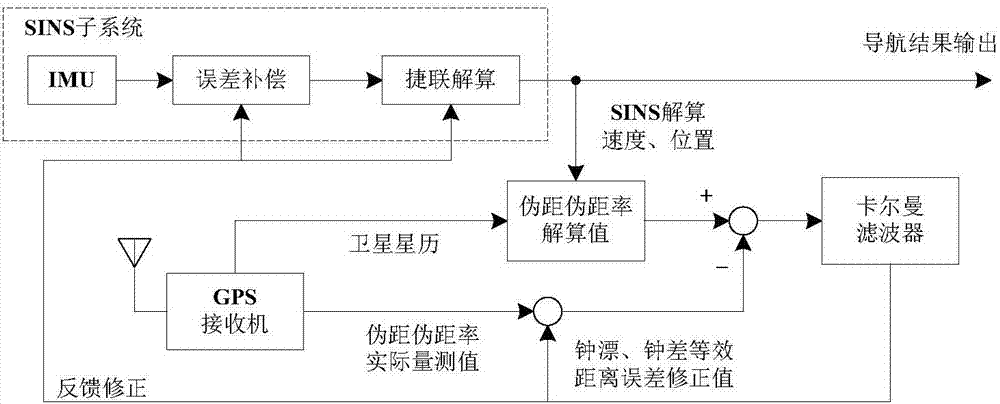
[0017] On the basis of satellite navigation technology, combined with chip atomic clock and micro inertial measurement combination technology based on micro-electromechanical system technology, a micro-terminal system for positioning, navigation and timing is formed. When the satellite signal service function is seriously insufficient or even unable to work normally, it can realize short-term high-precision autonomous positioning, navigation and timing functions. The invention proposes a data fusion method, which links the chip atomic clock, the Beidou navigation module and the micro-inertial navigation module, thereby improving the navigation accuracy and timing accuracy. The method mainly includes the following steps:

[0018] Step 1. In the positioning, navigation and timing microsystem, the atomic clock is communicated with the n...


PUM


Abstract

The invention discloses a data fusion method suitable for a positioning, navigating and time service microsystem. The method comprises the following steps: S1: supplying the output of an atomic clock to a navigation computer to serve as a crystal oscillator, analyzing information latched after a baseband signal is processed to obtain ephemeris, pseudorange and pseudo-range rate information; S2: carrying out data fusion on a micro inertia navigation module and a Beidou navigation module on the navigation computer: providing a time reference by the chip atomic clock, calculating carrier positions and speed information resolved by the micro inertia navigation module and satellite position and speed information provided by the ephemeris provided by the Beidou navigation module to obtain the pseudorange and the pseudo-range rate of the carrier; meanwhile, resolving by the Beidou navigation module to obtain the pseudorange and the pseudo-range rate, and then, carrying out combined Kalman filtering on the basis of a difference of the pseudorange and the pseudo-range rate to obtain the position, the speed and the gesture error of the carrier to correct the system. According to the method, the chip atomic clock, the Beidou navigation module and the micro inertia navigation module are connected to improve navigation accuracy and time service accuracy.

Description

[0001] 1. Technical field [0002] The invention relates to the technical field of integrated navigation, in particular to a data fusion method suitable for positioning, navigation and timing microsystems. [0003] 2. Background technology [0004] Due to its high precision, no long-term drift, all-weather full-time work, wide coverage area, near-real-time output of navigation data, and low terminal cost, the satellite navigation system has won extensive and in-depth applications in both military and civilian fields. application. With the satellite navigation system as the core, the positioning, navigation and timing technology can provide various users with precise positioning, navigation and timing services under a unified space-time reference. [0005] Existing various navigation systems have their advantages and characteristics respectively, but there are also deficiencies in themselves. The inertial navigation system has strong autonomy and complete functions, but its er...

Claims


Application Information

Patent Timeline
Patent Type & Authority Applications(China)
IPC IPC(8): G01C21/16
CPCG01C21/165
Inventor 陈帅赵琛孙昭行汪益平卢启伟陈德潘赵志鑫张嘉瑞姚晓涵
Owner NANJING UNIV OF SCI & TECH
Why Eureka
Try Eureka