Geomagnetic positioning navigation sensor

A technology of geomagnetic field and single-chip microcomputer, which is applied in the field of sensors, can solve the problems of high-rise signal shielding and susceptibility to electromagnetic interference, and achieve the effect of low manufacturing and maintenance costs and easy communication

Inactive Publication Date: 2018-09-07
国创智能设备制造股份有限公司
View PDF4 Cites 1 Cited by
  • Summary
  • Abstract
  • Description
  • Claims
  • Application Information

AI Technical Summary

Problems solved by technology

GPS positioning coverage is limited, vulnerable to electromagn

Method used


Image

  • Geomagnetic positioning navigation sensor

Examples


Embodiment Construction

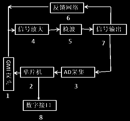
[0012] as attached figure 1 As shown, a geomagnetic positioning and navigation sensor, the single-chip microcomputer 2 provides an excitation signal to the GMI probe 1, which can collect the geomagnetic field signal, convert it into an electrical signal and perform signal amplification 4, in order to improve the signal-to-noise ratio. Then the key signal information of the magnetic field is extracted through wave detection 5 . After the signal output 7, a part of the signal is fed back to the GMI probe 1 through the feedback network 6, so as to expand the working range and improve the measurement stability; the other part of the signal is collected by AD 3, converted into a digital signal, transmitted to the single chip microcomputer 2 for processing and calculation, and finally The operation result is transmitted to the digital interface 8.

[0013] The core material of the GMI probe of the present invention is a Co-based amorphous wire produced by a special formula, which i...


PUM

PropertyMeasurementUnit
Diameteraaaaaaaaaa
Diameteraaaaaaaaaa
Average inner diameteraaaaaaaaaa

Abstract

The invention provides a geomagnetic positioning navigation sensor. The geomagnetic navigation sensor with a Co-based amorphous wire serving as a sensor probe has the advantages of being high in resolution, high in response speed, high in anti-interference performance, low in power consumption, small in size, good in stability and the like, and can be widely applied to positioning navigation of carriers (including but not limited to automobiles, ships, airplanes, aerospace and the like, the same as below). Compared with the prior art, the sensor has the remarkable advantages that the sensor isin a three-axis orthogonal special structure, a geomagnetic field three-component value can be tested, and position information of the carriers can be obtained through comparison with a geomagnetic map; the giant magneto-impedance effect of the amorphous wire is utilized so that the response speed of the sensor can reach 1 MHz, magnetic measurement can be carried out on the three-dimensional direction of measurement points, after vector calculation, positioning navigation is carried out by using the geomagnetic vector uniqueness principle of geomagnetic resources, and the sensor has the capacity of competing with a GPS; meanwhile, the sensor is not interfered by external signals, and is low in manufacturing and maintenance cost and easy to communicate with a computer; in the navigation (including but not limited to flight or sailing, running and moving, the same as below) process of the carriers whether the position and speed of the carriers in the range with the radius of 500 m are changed or not can be detected according to the principle that geomagnetic objects influence geomagnetic changes.

Description

technical field [0001] The invention relates to a geomagnetic positioning and navigation sensor, in particular to a magnetic navigation sensor using Co-based amorphous wire as a sensor probe. It belongs to the field of sensor technology. Background technique [0002] At present, the leading navigation in the world is firstly GPS, followed by Russia's GLONASS, and my country's Beidou navigation has also emerged, presenting a three-legged situation. The geomagnetic field is a vector field, and the magnetic field in each place is unique, so it can be associated with geographic coordinates and correspond one-to-one. Geomagnetic positioning and navigation is a new type of autonomous navigation technology developed by using the earth's common resource, the geomagnetic field. As a passive autonomous navigation method, it has the advantages of strong anti-interference ability, no accumulated error and moderate accuracy. GPS positioning coverage is limited, vulnerable to electromag...

Claims


Application Information

Patent Timeline
IPC IPC(8): G01C21/08
CPCG01C21/08
Inventor 李哲钱阳刘景毅李定朋高秀卫
Owner 国创智能设备制造股份有限公司
Why Eureka
Try Eureka