A device suitable for monitoring and receiving multi-system navigation signals

A navigation signal and multi-system technology, which is applied in the field of multi-system navigation signal monitoring and receiving devices, can solve the problems of unsatisfactory requirements, navigation signal monitoring and receiving device volume, complexity, and power consumption increase, and achieve low power consumption and strong Scalability, Small Effects

Active Publication Date: 2021-04-13
BEIJING RES INST OF TELEMETRY +1
View PDF12 Cites 0 Cited by
  • Summary
  • Abstract
  • Description
  • Claims
  • Application Information

AI Technical Summary

Problems solved by technology

Most of the current navigation signal monitoring and receiving devices are based on the design of only receiving certain signal components of Beidou-2 B1I, B2I and B3I navigation signals or Beidou-2 + GPS L1C / A and L2P dual-frequency navigation signals. The design can no longer meet the needs of current satellite navigation signal receiving equipment
[0003] To this end, designing a navigation signal monitoring and receiving device that receives all civil signals of the Beidou Global, GPS, GLONASS and Galileo systems requires the design of hundreds of independent receiving channels on the software, and requires higher signal processing speed and more on the hardware. FPGA logic resources, which will inevitably increase the volume, complexity and power consumption of the navigation signal monitoring and receiving device

Method used


Image

  • A device suitable for monitoring and receiving multi-system navigation signals
  • A device suitable for monitoring and receiving multi-system navigation signals
  • A device suitable for monitoring and receiving multi-system navigation signals

Examples


Embodiment Construction

[0030] The present invention will be further described below in conjunction with the accompanying drawings.

[0031] The satellite navigation receiving device of the present invention is integrated in a 2U chassis, and can simultaneously receive 28 Beidou global satellite civil signals (comprising B1I, B1C, B2I, B2a / b, B3I, B3C), 18 GPS satellite civil signals (comprising L1C / A, L1C, L2C, L2P, L5), 15 GLONASS satellite civil signals (including G1C / A, G2C / A, G3OC) and 15 Galileo satellite civil signals (including E1B / C, E5a, E5b), a total of 826 Independent receiving channel.

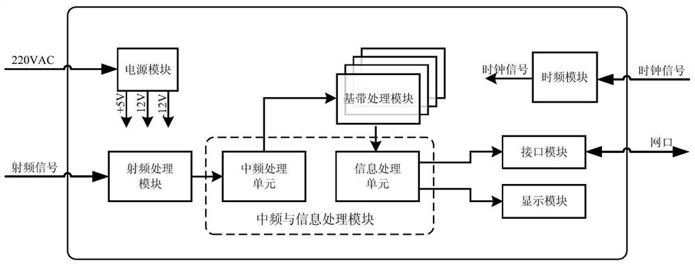
[0032] The device of the present invention adopts modular design, such as figure 1 As shown, the device suitable for monitoring and receiving multi-system navigation information includes a radio frequency processing module, an intermediate frequency and information processing module, a baseband processing module, an interface module, a display module, a power module, and a time-frequency module. The cor...


PUM


Abstract

A device suitable for monitoring and receiving multi-system navigation signals, including a radio frequency processing module and the like. The RF signal processed by the receiving antenna and the low-noise amplifier first enters the RF processing module, completes the analog down-conversion processing, and obtains the analog intermediate frequency signal; secondly, after AD sampling, enters the intermediate frequency processing unit of the intermediate frequency and information processing module, and completes the intermediate frequency processing of the signal and anti-jamming function to obtain the digital intermediate frequency signal; enter the baseband processing module again, complete the despreading and demodulation of the signal and send the signal to the information processing unit of the intermediate frequency and information processing module, and obtain the required observation data; finally the observation data is sent by the interface The module is sent to external data processing software through the network port to complete the monitoring function of navigation signals; the device of the present invention has the characteristics of small size, low power consumption, high integration and high measurement accuracy, and the receivable signals cover Beidou global, GPS, All civilian signals of the four systems of GLONASS and Galileo.

Description

technical field [0001] The invention relates to a device suitable for monitoring and receiving multi-system navigation signals, which belongs to the field of Beidou navigation. Background technique [0002] With the development of the global satellite navigation system, the satellite navigation signals existing in space have undergone tremendous changes in terms of the number of signal components and the signal system. At present, Beidou navigation system has seven civilian signals of B1I, B2I, B3I, B1C, B2a, B2b, and B3C; GPS has four signals of L1C / A, L2P, L2C, and L5; and Galileo has three signals of E1B / C, E5a, and E5b. Signal, GLONASS has two frequency division multiple access signals of L1 and L2 and one L3 code division multiple access signal. With the global networking of the Beidou system and the modernization of GPS, the new system signals B1C, B2a, L2C, and L5 will eventually replace B1I, B2I, B3I, and L1C / A signals. In addition, with the development of Galileo ...

Claims


Application Information

Patent Timeline
Patent Type & Authority Patents(China)
IPC IPC(8): G01S19/37G01S19/33
CPCG01S19/33G01S19/37
Inventor 孟祥艾伦成洁张彦超曾辉艳
Owner BEIJING RES INST OF TELEMETRY
Why Eureka
Try Eureka