Global scale remote sensing image water body intelligent extraction method based on multiple indexes

A remote sensing image and index technology, applied in image enhancement, image analysis, image data processing, etc., can solve problems such as inaccuracy and misclassification of results.

Inactive Publication Date: 2018-10-12
INST OF REMOTE SENSING & DIGITAL EARTH CHINESE ACADEMY OF SCI
View PDF3 Cites 21 Cited by
  • Summary
  • Abstract
  • Description
  • Claims
  • Application Information

AI Technical Summary

Problems solved by technology

However, for global-scale land surface water mapping, the current sample library can only refer to existing land surface water products
However, water bodies are greatly affected by seasons, that is to say, compared with water bodies in different time phases, the samples are inaccurate to a certain extent, which easily leads to misclassification of results

Method used


Image

  • Global scale remote sensing image water body intelligent extraction method based on multiple indexes
  • Global scale remote sensing image water body intelligent extraction method based on multiple indexes
  • Global scale remote sensing image water body intelligent extraction method based on multiple indexes

Examples


Embodiment Construction

[0014] The present invention is described in further detail below in conjunction with accompanying drawing:

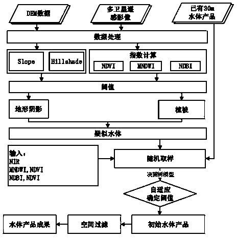
[0015] The present invention is based on the multi-index Landsat remote sensing image land surface water body rapid extraction method, comprising the following steps:

[0016] (1) Data processing

[0017] The present invention needs to carry out radiometric calibration on the adopted satellite remote sensing image data to obtain the reflectance on the satellite. The DEM data adopts SRTM 30m Dem data, which is longitude-latitude projection and WGS84 coordinate system. In order to adapt to the extraction of global land surface water body information, the global 30m Dem data can be mosaiced into the result of vrt format first, and then transprojected and cropped corresponding to the range of each satellite remote sensing data. Using the existing 2000 Landsat water product (GLCF-GIW) as a sample library, training and learning are carried out, so as to realize the adaptiv...


PUM


Abstract

The invention discloses a global scale remote sensing image water body intelligent extraction method based on multiple indexes. The invention belongs to the technical field of remote sensing image information mining, in particular to Landsat remote sensing image water body rapid extraction. A topographic index and normalized indices such as a water body, vegetation and architecture are comprehensively adopted, the problem of confusion between water body and mountain shadow, urban area, cloud shadow, ice and snow in the process of extracting satellite remote sensing images water body information. Moreover, the complexity of calculation is greatly simplified by using the index method, and the calculation speed of the algorithm can be effectively improved. At the same time, prior knowledge and a decision tree method are used to establish a rule model, thresholds are self-adaptively determined, strong universality is achieved, and the method can be well applied to the globally regional water information extraction. The method can rapidly, accurately and intelligently produce global epicontinental water products, and can be used for water resources monitoring, global change research, etc.

Description

technical field [0001] The technical field of the present invention is the mining of remote sensing image information, and specifically relates to the rapid and intelligent extraction of remote sensing image water bodies on a global scale. Background technique [0002] Water resources are an irreplaceable strategic resource for human survival and social development, and an indispensable and important basic information for global resource security and management, climate change research, and dynamic monitoring of the ecological environment. How to establish an effective method to scientifically, accurately and quickly extract the information of global land surface water bodies, and timely grasp the change information of land surface water bodies has become a key issue in the research of global changes such as water cycle. Because remote sensing technology has the characteristics of large-area synchronous observation, timeliness, comprehensiveness and comparability of data, an...

Claims


Application Information

Patent Timeline
Patent Type & Authority Applications(China)
IPC IPC(8): G06K9/62G06T7/11
CPCG06T7/11G06T2207/20132G06F18/24G06F18/214
Inventor 彭燕何国金江威刘慧婵
Owner INST OF REMOTE SENSING & DIGITAL EARTH CHINESE ACADEMY OF SCI
Why Eureka
Try Eureka