River pollution assessment method based on SPARROW model

A river pollution and river technology, which is applied in the field of river pollution assessment based on the SPARROW model, can solve the problems of quantitative distribution division assessment, difficulties in river pollution control, and inability to control polluted rivers in a targeted manner.

Inactive Publication Date: 2018-11-02
XINJIANG UNIVERSITY
View PDF1 Cites 10 Cited by
  • Summary
  • Abstract
  • Description
  • Claims
  • Application Information

AI Technical Summary

Problems solved by technology

[0004] The present invention provides a river pollution assessment method based on the SPARROW model, which overcomes the deficiencies of the above-mentioned prior art, and can effectively solve the components and pollution of pollution sources that do not poll

Method used


Image

  • River pollution assessment method based on SPARROW model
  • River pollution assessment method based on SPARROW model
  • River pollution assessment method based on SPARROW model

Examples


Embodiment 1

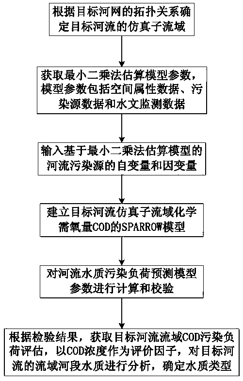
[0039] Embodiment 1: as attached figure 1 As shown, the river pollution assessment method based on the SPARROW model includes the following steps:

[0040] The first step is to determine the simulated sub-basin of the target river according to the topological relationship of the target river network. Based on the digital elevation model data of the sub-basin of the target river, use the ArcHydro tool set to follow the steps of depression filling, flow direction analysis, catchment calculation, river network definition and Segmentation and basin vectorization to obtain simulated river network hydrological data;

[0041] The above-mentioned simulated river network data is extracted from the DEM data by using the ArcHydro tool set in the Arcgis software to extract the main river systems in the basin. Based on Arcgis10.1 and ArcHydro, the above-mentioned basic data of the target river basin are processed and analyzed to obtain the simulated river network hydrology of the basin. d...

Embodiment 2

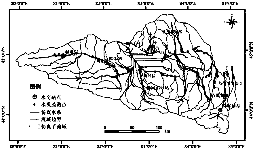
[0064] Embodiment 2: as figure 2 , 3 As shown, taking Xinjiang's largest inland saline Lake Aibi Basin as the water quality assessment object, the geographical location of the Aibi Lake Basin is between 43°38′-45°52′N and 79°53′-85°02′E In the basin, there are 7 rivers including Kuitun River, Sikeshu River, Guertu River, Jing River, Achale River, Dahe Yanzi River and Bortala River. The entire basin area is 50621km 2 . The basin is surrounded by mountains on three sides in the west, south and north, with a valley plain in the middle, and Lake Aibi in the east. The annual average precipitation in the lake area is less than 100mm, while the mountain area has relatively more precipitation, which is the main water supply area for the lake area. Based on the SPARROW model, the Aibi Lake Pollution assessment methods for the Bihu Basin, including the following:

[0065] (1) Based on Arcgis10.1, ArcHydro and NANI software, the basic data of Lake Aibi Basin are processed and analyze...


PUM


Abstract

The invention relates to the technical field of the river pollution assessment, and is a river pollution assessment method based on a SPARROW model. The method comprises the following steps: step one,determining a simulation sub-drainage area of a target river according to a topology relation of a target river network; step two, acquiring the least square method estimation model parameter; step three, determining and inputting the independent variable and the dependent variable of the river pollution source based on the least square method estimation model; step four, establishing a SPARROW model of a target river simulation sub-drainage area chemical oxygen demand; step five, checking a river water quality pollution load prediction model parameter; and step six, determining the water quality type. Through the method disclosed by the invention, the pollution source components and pollution load quantitative distribution in each sub-drainage area and each control unit in the target river drainage area can be obtained, thereby obtaining the macro influence on the drainage area water pollution status by different pollution constitute features in the target drainage area; the surfacewater pollution at inland drainage area at the arid region can be effectively assessed, and the surface water source at the target river drainage area can be effectively protected and scientifically managed.

Description

technical field [0001] The invention relates to the technical field of river pollution assessment, and relates to a river pollution assessment method based on the SPARROW model. Background technique [0002] Since the development of the SPARROW model in 1997, it has been rapidly developed and widely used. It can be used in the concentration distribution of pollutants such as organic matter, nutrients, suspended solids, and pathogenic microorganisms in surface waters of large and medium-scale watersheds, upstream and downstream load transmission, attenuation, and pollution source analysis. There are applications in both simulation and forecasting. The biggest feature of the SPARROW model lies in the model structure it adopts, that is, it divides the watershed spatially and forms a detailed river reach network, and the water quality monitoring data and the GIS data of the watershed attributes are spatially corresponding to the river reach network. . In recent years, the mode...

Claims


Application Information

Patent Timeline
IPC IPC(8): G06Q10/06G06F17/50
CPCG06Q10/0639G06F30/20Y02A20/152
Inventor 张飞任岩
Owner XINJIANG UNIVERSITY
Why Eureka
Try Eureka