Two-dimensional laser radar point cloud data processing method and dynamic robot posture calibration method

A two-dimensional laser radar and laser radar technology, which is applied in image data processing, instruments, image analysis, etc., can solve the problems of inconsistent data storage format and difficult guarantee of data accuracy, and achieve high efficiency and strong adaptability

Active Publication Date: 2018-12-04
NANCHANG UNIV
View PDF4 Cites 69 Cited by
  • Summary
  • Abstract
  • Description
  • Claims
  • Application Information

AI Technical Summary

Problems solved by technology

The rich point cloud data collected by lidar has a huge amount of information, the commonly used data storage format is not uniform, there are various deficiencies in storing data, and the data accuracy is difficult to guarantee. Therefore, the post-processing of lidar point cloud data has always been an important topic.
[0003] In order to o

Method used


Image

  • Two-dimensional laser radar point cloud data processing method and dynamic robot posture calibration method
  • Two-dimensional laser radar point cloud data processing method and dynamic robot posture calibration method
  • Two-dimensional laser radar point cloud data processing method and dynamic robot posture calibration method

Examples


Embodiment 1

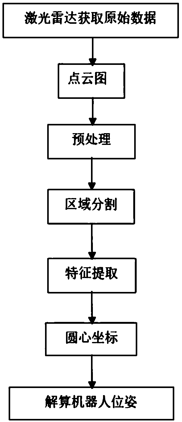
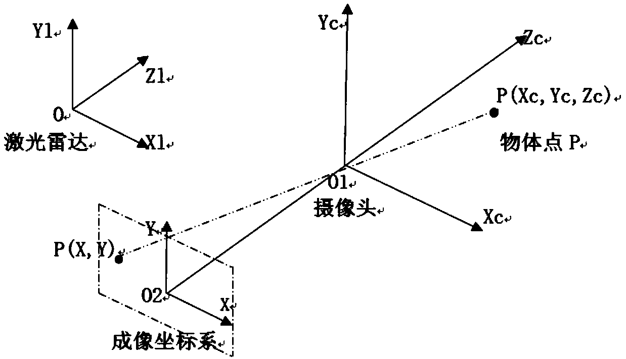
[0021] see figure 1 , the two-dimensional lidar point cloud data processing method of the present invention, the original data of the environment collected by the lidar scanning is firstly subjected to point cloud data preprocessing, and the polar coordinate system with the lidar as the coordinate point is converted into a robot pose calibration. Cartesian coordinate system, and then use area segmentation algorithm, feature extraction algorithm, point cloud segmentation algorithm, two-dimensional laser radar and camera fusion detection algorithm to realize effective detection and recognition of environmental information, the process includes:

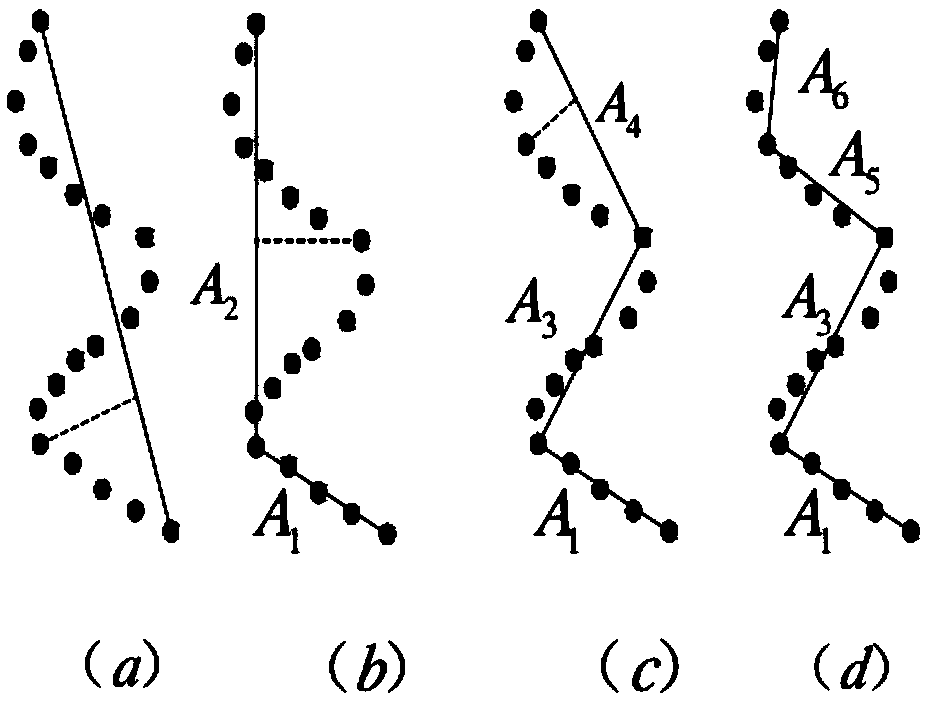
[0022] The use judgment method of the described area segmentation algorithm is: if the distance between two consecutive scanning points is less than a certain threshold, then these two scanning points are attributed to the same block; comparing two consecutive scanning points, if their distance If it is greater than a certain threshold,...

Embodiment 2

[0026] see figure 1 , figure 2 The difference between the two-dimensional laser radar point cloud data processing method of this embodiment and Embodiment 1 is that: the point cloud data preprocessing algorithm includes a filtering algorithm, removing abnormal values ​​and coordinate transformation; filtering algorithm, removing abnormal values The value can effectively eliminate the interference information in the environment; the coordinate transformation converts the polar coordinate system with the lidar as the coordinate point into the rectangular coordinate system used for robot pose calibration;

[0027] 1) The filtering algorithm adopted is as follows:

[0028] Due to the interference of the environment, the scan data returned by the lidar includes noise. Noise can be effectively eliminated by using an appropriate filtering algorithm. The median filter with a selected window width of 7 can effectively filter out the noise in the discrete point cloud data and retain...

Embodiment 3

[0037] see figure 1, the two-dimensional lidar point cloud data processing method of the present embodiment is different from embodiment 2 in that: the region segmentation algorithm, when a certain scanning point A is D from the lidar center point O, set The segmentation distance threshold is d, and when the scanning point is 3D away from the lidar center, the threshold is adjusted to 3d; according to the actual application, a nonlinear function can also be used to define the adaptive segmentation threshold; the area segmentation algorithm used is as follows:

[0038] a. Calculate the distance between two consecutive points in the point set

[0039]

[0040] b. Judging the relationship between Dj and threshold θ,

[0041] If Dj, is greater than the threshold θ, the point (x, y) is considered to be the segmentation point of the two regions, and the selection of the threshold is generally in accordance with the dynamic threshold. After following the above steps step by step...


PUM


Abstract

The invention discloses a two-dimensional laser radar point cloud data processing method. Environmental data is collected through laser radar scanning, point cloud data pre-processing is performed, apolar coordinate system with laser radar being a coordinate point is converted into a rectangular coordinate system that is used for posture calibration of a robot, environmental information is effectively detected and recognized through region segmentation, feature extraction, point cloud segmentation, two-dimensional laser radar and a camera fusion detection algorithm, and three-dimensional coordinate fusion is conducted through a vent needle model of the camera and the laser radar, so that the robot calibrates the posture according to a deviation. The invention also discloses a dynamic robot posture calibration method, wherein a camera is adopted as an auxiliary detection sensor and obtains the real-time posture state of the robot together with laser radar, the adjustment amount of a calibration system is obtained by comparing the real-time posture state with a desired posture state, calibration is continuously carried out until the deviation between the robot posture detected by the laser radar and the desired posture is less than a certain threshold value, and thus a whole closed-loop posture calibration process is completed.

Description

technical field [0001] The invention relates to a two-dimensional laser radar point cloud data processing method / algorithm, and its application to the design of a dynamic robot pose calibration system. Background technique [0002] Judging from the current development status, intelligent robot technology is still facing various difficulties. For this reason, there have been many robot competitions. One of the focuses of the examination is the environmental modeling of intelligent robots. Environmental modeling is the basis for intelligent robots to achieve environmental information exchange. The only channel, so technological breakthroughs are imperative. In recent years, driven by the application of transportation, power transmission, construction and other industries in my country, lidar technology has developed rapidly. The rich point cloud data collected by lidar has a huge amount of information, the commonly used data storage format is not uniform, there are various de...

Claims


Application Information

Patent Timeline
IPC IPC(8): G06T7/73G06T5/00G06T7/11G06T7/62G06T5/50
CPCG06T5/002G06T5/50G06T7/11G06T7/62G06T7/73G06T2207/10044G06T2207/10028G06T2207/20221G06T2207/20032
Inventor 严萍陈勇李剑锋史鑫张馨怡刘德亮
Owner NANCHANG UNIV
Why Eureka
Try Eureka