Simultaneous positioning and mixed map construction method for dynamic parking environment

A hybrid map and construction method technology, applied in image analysis, image data processing, measuring devices, etc., can solve the problems of low parking efficiency and inability to reuse, and achieve the effects of long residence time, improved efficiency, and improved positioning accuracy

Active Publication Date: 2019-01-11
BEIJING INSTITUTE OF TECHNOLOGYGY
View PDF6 Cites 39 Cited by
  • Summary
  • Abstract
  • Description
  • Claims
  • Application Information

AI Technical Summary

Problems solved by technology

Due to the characteristics of dynamic changes in the parking environment, the existing environmental perception system cannot meet the needs of a fully autonomous parking system. The constructed parking lot map is often not reusable due to environmental changes, so the vehicle must Rebuild the environment map, the parking efficiency is extremely low

Method used


Image

  • Simultaneous positioning and mixed map construction method for dynamic parking environment
  • Simultaneous positioning and mixed map construction method for dynamic parking environment
  • Simultaneous positioning and mixed map construction method for dynamic parking environment

Examples


Embodiment 1

[0030] Embodiment 1. A panoramic stereo vision SLAM method for a dynamic parking environment.

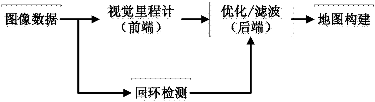
[0031] figure 2 It is the system architecture of the current mainstream SLAM method, which is divided into data image, visual odometry, back-end optimization, map construction and loop detection modules. In terms of data input, currently monocular cameras, binocular cameras, and RGB-D cameras are mainly used. Among them, binocular cameras are widely used in unmanned driving technology because of their accurate scale information; in the visual odometer module, according to the implementation method The difference can be divided into two categories, one is the feature point method based on image feature extraction, and the other is the direct method based on image gray level change. The feature point method extracts the corner points or spots with obvious grayscale changes in the image and calculates their corresponding descriptors, and then uses epipolar geometry or projective geom...

Embodiment 2

[0036] Embodiment 2. A method for constructing a topological map of a parking lot environment.

[0037] image 3 For the panoramic image and its disparity map obtained by using the omni panoramic stereo camera, since the binocular camera can directly obtain the actual coordinates of the three-dimensional objects in the environment according to the binocular dense matching method, it is easy to construct Figure 4 The 3D dense point cloud map shown in , the 3D dense point cloud map is obtained by calculating the position in the 3D space corresponding to each pixel in the image. However, due to the large space occupied by the original three-dimensional grid and low storage efficiency, many scholars have applied some efficient data structures in the process of composition. The more famous work includes Octomap using the octree structure. Figure 5 The map shown in is the octree map, and the raster map is obtained by rasterizing the 3D dense point cloud map.

[0038] Further, af...

Embodiment 3

[0043] Embodiment 3, a method for extracting semantic information of a parking lot environment and constructing a hybrid map.

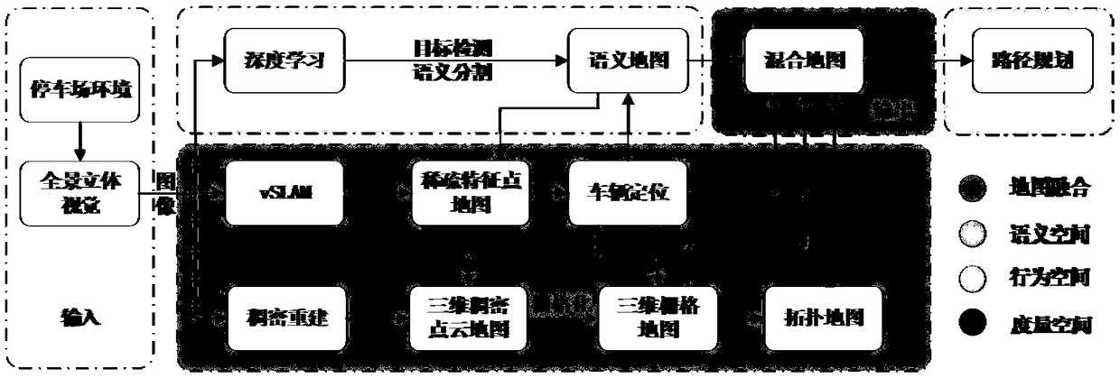
[0044] Figure 7 In is the semantic information of the parking lot extracted by deep learning algorithms such as semantic segmentation and target detection. Different colors can be used to represent buildings, roads, vehicles, parking spaces or lane lines. The semantic map of the environment can be constructed by using this semantic information combined with the previously obtained vehicle pose, environmental disparity map, etc. Semantic information will also be used for data fusion and removal of dynamic targets in the feature point map. Finally, the 3D grid map, topological map and semantic map are fused to construct a topological-semantic hybrid map that can be used for vehicle route planning and navigation.

[0045] At present, there are two main methods for extracting semantic information using deep learning architectures: target recognition an...


PUM


Abstract

The invention discloses a simultaneous positioning and mixed map construction method for a dynamic parking environment. By introducing environmental semantic information for data association, a dynamic target in a feature point map for realizing positioning is removed, and meanwhile, static state semantic information such as parking spots is introduced during the positioning, so that the positioning precision in the dynamic environment is improved; a full-view stereoscopic vision platform is taken as a unique environmental perception source of the system and is combined with the advantages offull-view cameras and vision, so that the environmentally accurate dimension information is realized; meanwhile, the view is wide, and the standing time of feature points in the map is long, so that the positioning precision can be increased; and the semantic information such as the parking spots can be fused with a topologic road network structure in the environment, so that the route planning efficiency can be effectively improved, and the instantaneity of an autonomous parking system is further improved.

Description

technical field [0001] The invention belongs to the field of autonomous parking in the aspect of unmanned driving, and relates to the simultaneous positioning and map construction method of a ground unmanned mobile platform in a dynamically changing parking lot to complete accurate positioning and hybrid map construction. Background technique [0002] In recent years, with the development of society and the advancement of science and technology, the number of global automobile ownership and automobile production has continued to rise. The popularity of cars has caused problems such as traffic congestion and parking difficulties. In addition, because the space of the parking lot is generally crowded and narrow, there are endless cases of scratching and even casualty accidents during the parking process due to human error. [0003] At present, intelligent parking systems are mainly divided into passive parking assistance, semi-autonomous parking and fully autonomous parking. ...

Claims


Application Information

Patent Timeline
Patent Type & Authority Applications(China)
IPC IPC(8): G01C21/00G06T7/80
CPCG06T7/80G01C21/005
Inventor 杨毅王健行蒋斯坦唐笛付梦印
Owner BEIJING INSTITUTE OF TECHNOLOGYGY
Why Eureka
Try Eureka