Sub-surface detection radar sub-satellite point pulse precise positioning method

A detection radar and precise positioning technology, applied in the field of satellite-borne subsurface imaging radar, can solve the problems of inability to accurately control the position of the radar sub-satellite point, different electromagnetic wave propagation and refraction, affecting the processing of radar echoes, etc., to improve product safety. and reliability, accelerate the development progress, reduce the effect of verification cost

Active Publication Date: 2019-03-08
CHINA ELECTRONIC TECH GRP CORP NO 38 RES INST
View PDF12 Cites 2 Cited by
  • Summary
  • Abstract
  • Description
  • Claims
  • Application Information

AI Technical Summary

Problems solved by technology

[0003] However, when the existing synthetic aperture radar detects the space-borne subsurface, it needs to image different surface layers of the target star. The dielectric coefficient of different surface layers leads to different propagation and refraction of electromagnetic waves, so it is impossible to accurately control the position of the radar sub-satellite point , resulting in affecting the processing of radar echoes, resulting in poor imaging quality

Method used


Image

  • Sub-surface detection radar sub-satellite point pulse precise positioning method
  • Sub-surface detection radar sub-satellite point pulse precise positioning method
  • Sub-surface detection radar sub-satellite point pulse precise positioning method

Examples


Embodiment 1

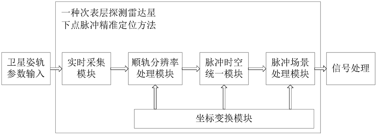
[0052] Such as figure 1 as shown, figure 1 It is a flow chart of the sub-surface detection radar sub-satellite point pulse positioning method of the present invention; the sub-surface detection radar sub-satellite point pulse precise positioning method is used to realize the precise positioning of the star surface and sub-surface imaging area by the spaceborne imaging radar. The subsurface detection radar sub-satellite point pulse precise positioning method mainly includes steps:

[0053] S1, the real-time acquisition module performs real-time acquisition and processing of the satellite information input by the satellite platform;

[0054] S2, the on-track resolution processing module performs on-track resolution processing according to the satellite information to obtain the current on-track resolution;

[0055] S3, the pulse scene processing is performed through the pulse space-time unified module, the coordinate transformation module, and the pulse scene processing module...

Embodiment 2

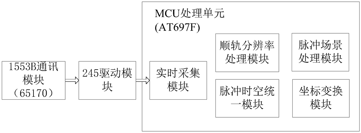
[0061] In this embodiment, the subsurface detection radar sub-satellite point pulse precise positioning method is to implement the real-time acquisition module, the along-track resolution processing module, and the coordinate transformation through an MCU (Microcontroller Unit). module, the pulse spatiotemporal unification module, and the specific functions of the pulse scene processing module.

[0062] Such as figure 2 as shown, figure 2 It is the equipment flowchart of the subsurface detection radar sub-satellite point pulse positioning method of the present invention; the subsurface detection radar sub-satellite point pulse positioning method of the present invention mainly includes a communication module, a drive module, and an MCU processing unit.

[0063] The communication module adopts a 1553B communication module, and the communication module mainly communicates with the star interface chip through the RT terminal interface chip to receive the satellite information ...

Embodiment 3

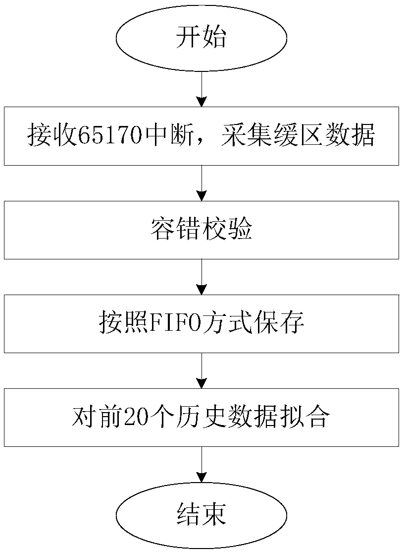
[0065] Such as image 3 as shown, image 3 It is a flowchart of step S1, and step S1 mainly includes:

[0066] S11, waiting for the RT interface core to be interrupted, judging whether it is the sub-address specified by the satellite information, and collecting data in the receiving buffer of the RT interface core;

[0067] S12. Perform fault-tolerant check on the satellite information, and save the correct satellite information in an internal variable table in a FIFO manner;

[0068] S13, for the historical information of the first 20 satellite information received, the least squares method is used to fit the satellite information, that is, the orbital height information, pitch attitude angle, yaw attitude angle, roll attitude angle , Pitch angular velocity, yaw angular velocity, rolling angular velocity, X / Y / Z axis position information of the star coordinate system, and X / Y / Z axis velocity information of the star coordinate system are fitted to obtain satellite information...


PUM


Abstract

The invention discloses a sub-surface detection radar sub-satellite point pulse precise positioning method. The method includes the following steps that: a real-time acquisition module performs real-time acquisition and processing on satellite information inputted by a satellite platform; an along-orbit resolution processing module performs along-orbit resolution processing on the satellite information so as to obtain current along-orbit resolution; and pulse scene processing is performed through a pulse space-time unification module, a coordinate transformation module, and a pulse scene processing module. With the sub-surface detection radar sub-satellite point pulse precise positioning method of the invention, the pulse scenes of a sub-surface detection radar can be accurately positioned; the size of an imaging scene can be accurately controlled; accurate results are provided for signal processing and windowing size control; the amount of data processing for the signal processing canbe reduced; development progress can be accelerated; verification costs can be reduced; subsequent changes can be reduced; and product safety and reliability are improved.

Description

technical field [0001] The invention relates to the technical field of satellite-borne subsurface imaging radar, in particular to a subsurface detection radar sub-satellite point pulse precise positioning method. Background technique [0002] Synthetic Aperture Radar (SAR) is a high-resolution microwave remote sensing imaging radar. It uses a smaller antenna to form a virtual equivalent long antenna through the synthetic aperture principle and pulse compression technology to obtain high azimuth resolution of the target. radar image. Synthetic aperture radar has high resolution, can work in all weathers, and can effectively identify camouflage and penetrate cover. [0003] However, when the existing synthetic aperture radar detects the space-borne subsurface, it needs to image different surface layers of the target star. The dielectric coefficient of different surface layers leads to different propagation and refraction of electromagnetic waves, so it is impossible to accura...

Claims


Application Information

Patent Timeline
Patent Type & Authority Applications(China)
IPC IPC(8): G01S13/90G01S13/88
CPCG01S13/887G01S13/90
Inventor 冯俊涛杜易吕鹏林洪娟
Owner CHINA ELECTRONIC TECH GRP CORP NO 38 RES INST
Why Eureka
Try Eureka