Lightweight method of high-precision digital elevation model

A digital elevation model and lightweight technology, applied in height/horizontal measurement, measuring devices, instruments, etc., can solve the problems of DEM data redundancy and large memory, reduce the amount of point cloud model data, and the surface of the model is not smooth. Achieve the effect of supporting digital analysis, reducing field workload, and being real and intuitive against terrain fluctuations

Pending Publication Date: 2020-02-07
CHINA RAILWAY ERJU 1ST ENG
View PDF5 Cites 2 Cited by
  • Summary
  • Abstract
  • Description
  • Claims
  • Application Information

AI Technical Summary

Problems solved by technology

[0003] The invention provides a lightweight method for a high-precision digital elevation model. Aiming at the defects of the existing DEM data redundancy and large memory, rough surface of the model, and low terrain accuracy, it focuses on the establishment of an aerial model based on UAV aerial photography data. Triangulation solution process, producing high-precision point cloud models, reducing the data volume of point cloud models through point cloud resampling, importing aerial survey software to do multiple aerial three-dimensional processing to produce 3D terrain models, and filling holes in the 3D models and Surface processing, producing high-precision DEM models with smooth performance and small data volume

Method used


Image

  • Lightweight method of high-precision digital elevation model

Examples


Embodiment

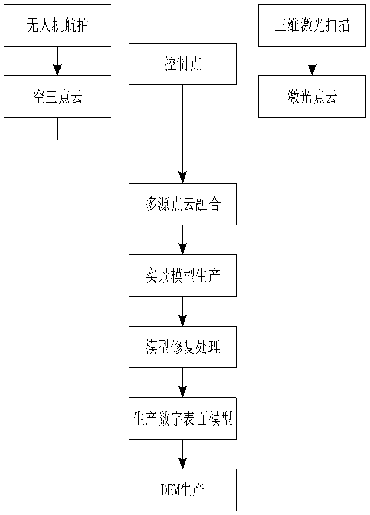
[0037] Refer to attached figure 1 , this embodiment provides a lightweight method for a high-precision digital elevation model, the specific method is as follows:

[0038] (1) Multi-source point cloud model collection

[0039] The image control points are laid out on the ground, the coordinate values ​​are measured by GPS, and the coordinate values ​​are converted into the WGS84 coordinate system, and the projection method is on the Transverse Mercator (UTM) datum;

[0040] Set the flight parameters of the UAV, collect multi-view images, establish the first aerial triangulation calculation process under the WGS84 coordinate reference, and produce point cloud data in LAS format;

[0041] Based on the two control points that communicate with each other, a Tianbao SX10 3D laser scanner is set up to collect point cloud data of areas with complex vegetation (retaining walls, inside forests).

[0042] (2) Multi-source point cloud model fusion

[0043] In the TBC software, import ...


PUM


Abstract

The invention provides a lightweight method of a high-precision digital elevation model. According to the method, the DEM is subjected to lightweight processing twice, the data size of the point cloudmodel can be reduced to about 100 times by resampling the point cloud data for the first time, the digital surface model with relatively low data memory is obtained by multiple aerial triangulation calculation processes and model repair, and the topographic precision is not reduced; the second lightweight processing is realized by setting the interval of DEM resampling, the obtained DEM precisionis within 1m, and the defects that the existing DEM data redundancy and memory are large, the model surface is not smooth, the terrain precision is not high and the like are effectively overcome. Theinvention belongs to the field of constructional engineering.

Description

technical field [0001] The invention relates to a lightweight method for a high-precision digital elevation model, which is especially suitable for the production and application of a three-dimensional real terrain model, and belongs to the field of construction engineering. Background technique [0002] In recent years, with the increasing integration of construction industry informatization, the BIM+ application model has gradually penetrated into each stage of construction. Among them, the most valuable application should be the integrated application of "BIM+GIS", which has a natural complementary relationship. For the application of BIM+GIS, the core is to solve the source of terrain data. At present, GIS data is mainly obtained through authoritative platforms, which can download digital elevation models (hereinafter referred to as DEM) with terrain accuracy of about 30 meters, and some institutions can obtain accuracy 10 DEM, but the cost is higher. On the other hand,...

Claims


Application Information

Patent Timeline
Patent Type & Authority Applications(China)
IPC IPC(8): G06F30/13G01C5/00
CPCG01C5/005
Inventor 谢显龙胡光全赵宏何寿海崔宇李国栋米才标梁旋吴真元熊峰袁恩培黄俊峰原菊星雍婷婷李永康
Owner CHINA RAILWAY ERJU 1ST ENG
Why Eureka
Try Eureka