Combined self-positioning and self-orientation polar compass device

An autonomous positioning and combined technology, applied in measuring devices, compasses, surveying and navigation, etc., can solve the problems of limited application of algorithms, poor positioning accuracy, weak dynamic performance, etc., to overcome low output frequency, fast start-up speed, The effect of improved navigation accuracy

Inactive Publication Date: 2020-07-03
BEIJING INFORMATION SCI & TECH UNIV
View PDF5 Cites 5 Cited by
  • Summary
  • Abstract
  • Description
  • Claims
  • Application Information

AI Technical Summary

Problems solved by technology

Such as the neural network algorithm and the genetic algorithm of the support vector machine, the online training model is used when the satellite signal is valid, and the existing model parameters are used to estimate the error when the GNSS is out of lock. Due to the complexity of the algorithm, the application in engineering is limited.
The existing navigation equipment in the polar region includes satellite navigation system, HF radio communication, LNAV communication and navigation, etc. Although the problem of polar navigation and positioning has been solved, such products mainly rely on radio communication and navigation, which cannot solve the problem of positioning when radio abnormalities occur. Poor accuracy, heading inaccuracy, and the dynamic performance of such products is weak

Method used


Image

  • Combined self-positioning and self-orientation polar compass device
  • Combined self-positioning and self-orientation polar compass device
  • Combined self-positioning and self-orientation polar compass device

Examples


Embodiment Construction

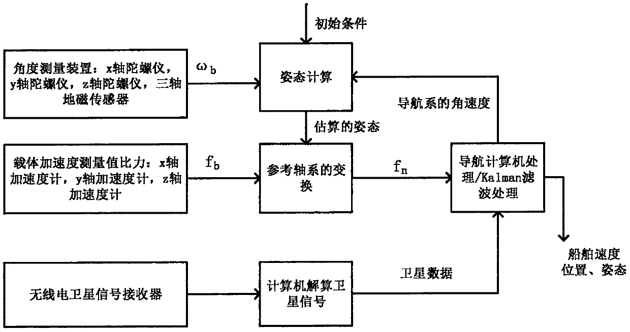
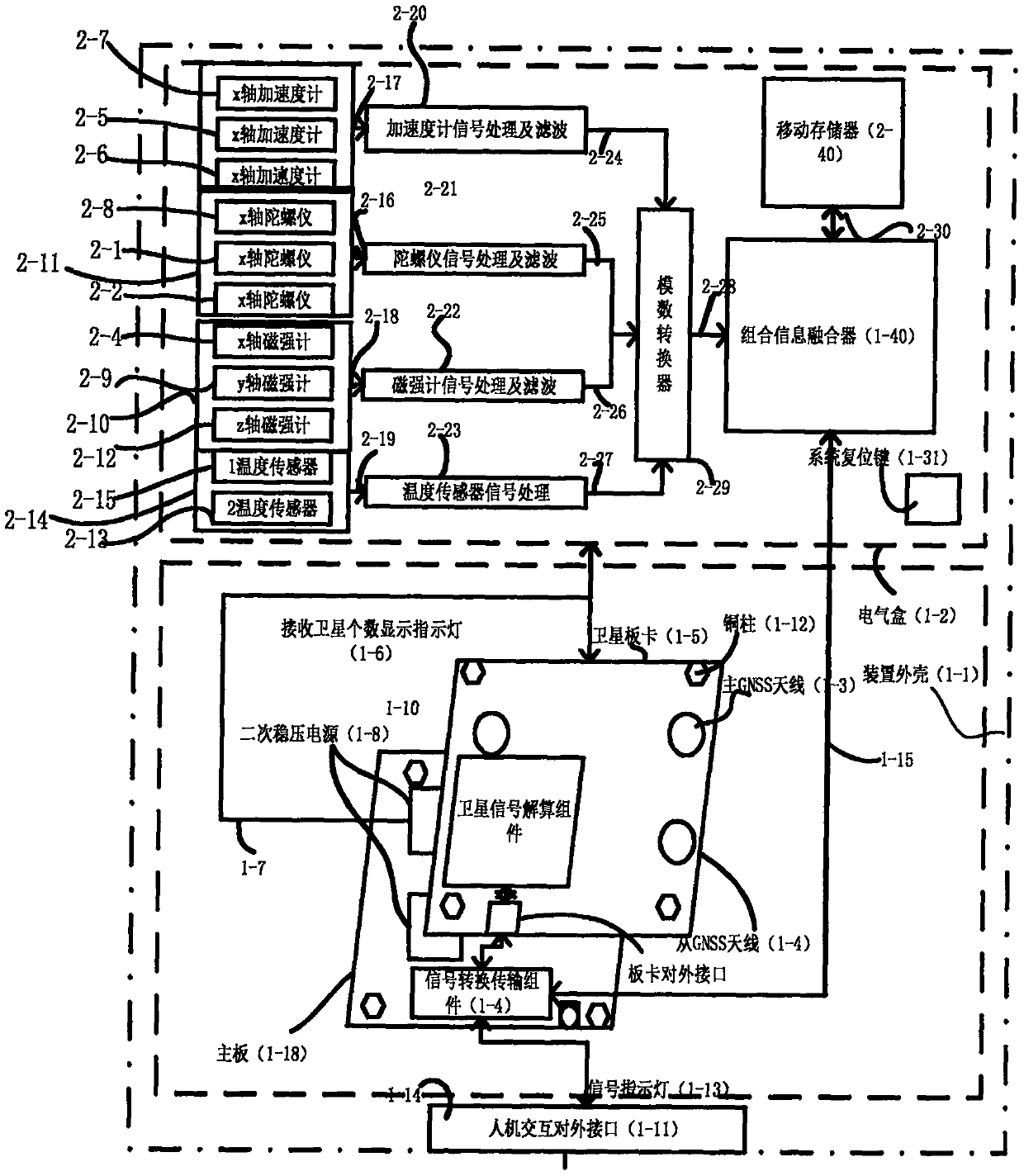
[0015] The invention discloses a human body irregular movement sensing type navigation belt, which comprises an inertial information sensing component, a satellite signal solving component, a satellite signal receiving component, a magnetic field strength sensing component, a temperature sensing component, a human-computer interaction interface, a data processing component, Data transmission components, secondary power supplies and enclosures.

[0016] Inertial information perception components include: x-axis gyroscope (2-1), y-axis gyroscope (2-2), z-axis gyroscope (2-4), x-axis accelerometer (2-5), y-axis accelerometer (2-6) and z-axis accelerometers (2-8). Among them, the x-axis gyroscope (2-1), the y-axis gyroscope (2-2), and the z-axis gyroscope (2-4) constitute the gyroscope subsystem (2-3) of the inertial measurement unit; the x-axis acceleration The accelerometer (2-5), the y-axis accelerometer (2-6) and the z-axis accelerometer (2-8) constitute the accelerometer sub...


PUM


Abstract

The invention discloses a combined self-positioning and self-orientation polar compass device. The device comprises an inertia information sensing assembly, a satellite signal resolving assembly and the like. All the assemblies are combined integrally, so that not only is the electronic interference resistance of an inertial navigation system achieved, but also the advantages that the positioningerror of a satellite navigation system is irrelevant to time accumulation and all-weather real-time positioning is achieved, and the characteristic that the error of an inertial navigation device is accumulated along with time and the defect that satellite navigation signals are prone to interference are complemented. The device is mainly applied to navigation, positioning and motion state monitoring of ships in a polar region range. And the device is particularly applied to special geographic areas needing to be positioned, such as affected satellite navigation in case of radio failure. The system navigation precision is improved; and the device is simple in structure, high in positioning precision, small in size, easy to install, low in power and particularly suitable for scenes of real-time positioning and moving body state monitoring in the polar region range.

Description

technical field [0001] The invention relates to a navigation compass device for autonomous positioning and orientation in polar regions, in particular to a combined navigation compass for polar complex environments. Background technique [0002] Although with the development of satellite navigation and wireless communication technology, through methods such as satellite positioning, preset beacons and digital map matching, the location information of individuals or moving bodies can be easily obtained. However, for the non-beacon environment (poor radio signal quality, WiFi, satellite and other communication systems, etc. cannot be used), especially in the extreme weather conditions and special geographical conditions in the polar region, the accuracy of the traditional compass is reduced, and the nautical chart is not easy to use. , the lack of shore-based navigation aids, the rapid course change, the lack of ground navigation equipment, and the magnetically unreliable pola...

Claims


Application Information

Patent Timeline
Patent Type & Authority Applications(China)
IPC IPC(8): G01C17/38
CPCG01C17/38
Inventor 刘宁苏中王海璐李擎付国栋范军芳刘洪仇海涛
Owner BEIJING INFORMATION SCI & TECH UNIV
Why Eureka
Try Eureka