Method and system for acquiring global rainfall information at different places by utilizing rainfall data set
A rainfall data and rainfall technology, applied in data processing applications, instruments, forecasting, etc., can solve the problems of uneven distribution, lack of data, and less rainfall research, and achieve the effect of fast calculation speed and improved accuracy
- Summary
- Abstract
- Description
- Claims
- Application Information
AI Technical Summary
Problems solved by technology
Method used
Image
Examples
Embodiment 1
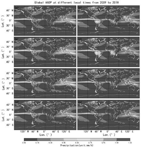
[0047] Such as figure 1 As shown, embodiment 1 of the present invention provides the method that utilizes rainfall dataset to obtain global rainfall information in different places, including:
[0048] Step 101) raw data preparation: mainly collect and summarize existing global rainfall data sets;
[0049]The data mainly uses the ERA5 reanalysis precipitation grid data estimated in hours from 2009 to 2018, with a horizontal resolution of 0.25°×0.25°. The ERA5 reanalysis data is the fifth generation global reanalysis data of ERA5 issued by the European Center for Medium-Range Weather Forecasting (ECMWF), and is continuously developed by the Copernicus Climate Change Service (C3S) in near real time, covering the time period from 1950 to the present (with a three-month lag) data is currently the most advanced reanalysis product in technology. The processing of ERA5 data is carried out by using the Integrated Forecast System (IFS) developed by ECMWF with the cycle label 41r2, us...
Embodiment 2
[0068] Such as image 3 As shown, Embodiment 2 of the present invention provides a method for utilizing rainfall data sets to obtain global rainfall information in different places, including:
[0069] Step 201) Raw data preparation.
[0070] The data collection mainly adopts the TRMM 3B42RT V7 multi-satellite precipitation analysis data from 2009 to 2018 and the hourly precipitation measurement data of meteorological stations within 60°N-S provided by NCEI.
[0071] The TRMM 3B42RT V7 dataset has a horizontal resolution of 0.25°×0.25°, a time resolution of 3 hours, and a delay of 8 hours from real time, covering the 60°N-S region of the world. The file format is NetCDF, and it is downloaded from NASA’s GEC DISC get.
[0072] Step 202) Kriging spatial interpolation.
[0073] Studies have shown that TRMM rainfall products have obvious spatial variability and uncertainty. Although it has good applicability in low latitude and flat areas, its accuracy is low in areas with high...
Embodiment 3
[0084] Embodiment 3 of the present invention provides a system for utilizing rainfall data sets to obtain global rainfall information in different places, including:
[0085] Universal Time Global Rainfall Data Acquisition Module, which is used to collect and aggregate global rainfall data sets to obtain global rainfall data based on Universal Time;
[0086] The spatial interpolation module is used to perform spatial interpolation on global rainfall data based on universal time to obtain gridded global rainfall data based on universal time;
[0087] The time zone conversion module is used to convert global rainfall data based on universal time to global rainfall data based on specified local time;
[0088] The time interpolation module is used to use the global rainfall data of any adjacent three days based on universal time as the original data set, and use adjacent point interpolation to obtain the global rainfall data of one hour intervals on the second day, thus obtaining ...
PUM
 Abstract
Description
Claims
Application Information
 - R&D
- Intellectual Property
- Life Sciences
- Materials
- Tech Scout
- Unparalleled Data Quality
- Higher Quality Content
- 60% Fewer Hallucinations
Browse by: Latest US Patents, China's latest patents, Technical Efficacy Thesaurus, Application Domain, Technology Topic, Popular Technical Reports.
© 2025 PatSnap. All rights reserved.Legal|Privacy policy|Modern Slavery Act Transparency Statement|Sitemap|About US| Contact US: help@patsnap.com


