Navigation positioning device and method in spacecraft cluster ground simulation system

A ground simulation, navigation and positioning technology, applied in measurement devices, navigation calculation tools, and optical devices, etc., can solve problems such as being susceptible to interference, and achieve the effect of improving anti-interference ability, increasing operating speed, and reducing the amount of calculation.

Pending Publication Date: 2020-10-13
HARBIN INST OF TECH
View PDF0 Cites 12 Cited by
  • Summary
  • Abstract
  • Description
  • Claims
  • Application Information

AI Technical Summary

Problems solved by technology

The pose measurement system proposed in it can accurately obtain the relative pose of the moving object and the camera with the least amount of hardware, but the syste

Method used


Image

  • Navigation positioning device and method in spacecraft cluster ground simulation system
  • Navigation positioning device and method in spacecraft cluster ground simulation system
  • Navigation positioning device and method in spacecraft cluster ground simulation system

Examples


Embodiment 1

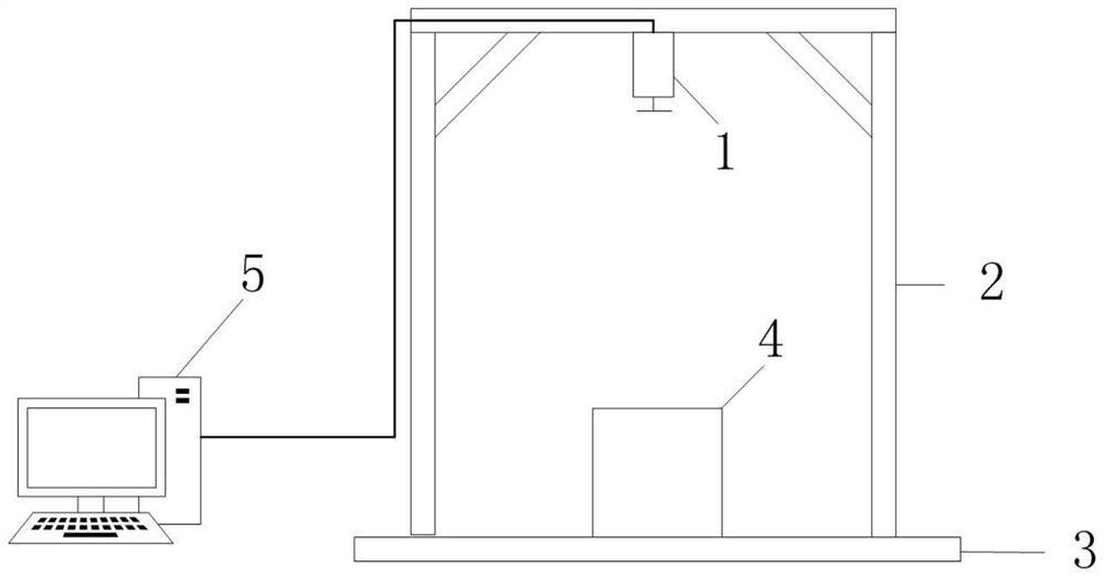
[0035] Such as figure 1 As shown, the spacecraft cluster navigation and positioning device consists of an industrial camera 1 , a camera bracket 2 , a test bench 3 , a moving target 4 and a pose measurement PC 5 . Among them, the industrial camera 1 lens is equipped with a red filter, the camera bracket 2 is fixedly connected with the industrial camera 1, and is used to support the industrial camera 1, and the moving target 4 performs one-dimensional rotation and two-dimensional translation on the test bench 3. The industrial camera 1. Collect the image containing the moving target 4 and transmit it to the pose measurement PC 5. The pose measurement PC 5 calculates the pose information of the moving target 4 in the three-dimensional space according to the two-dimensional coordinates of the image.

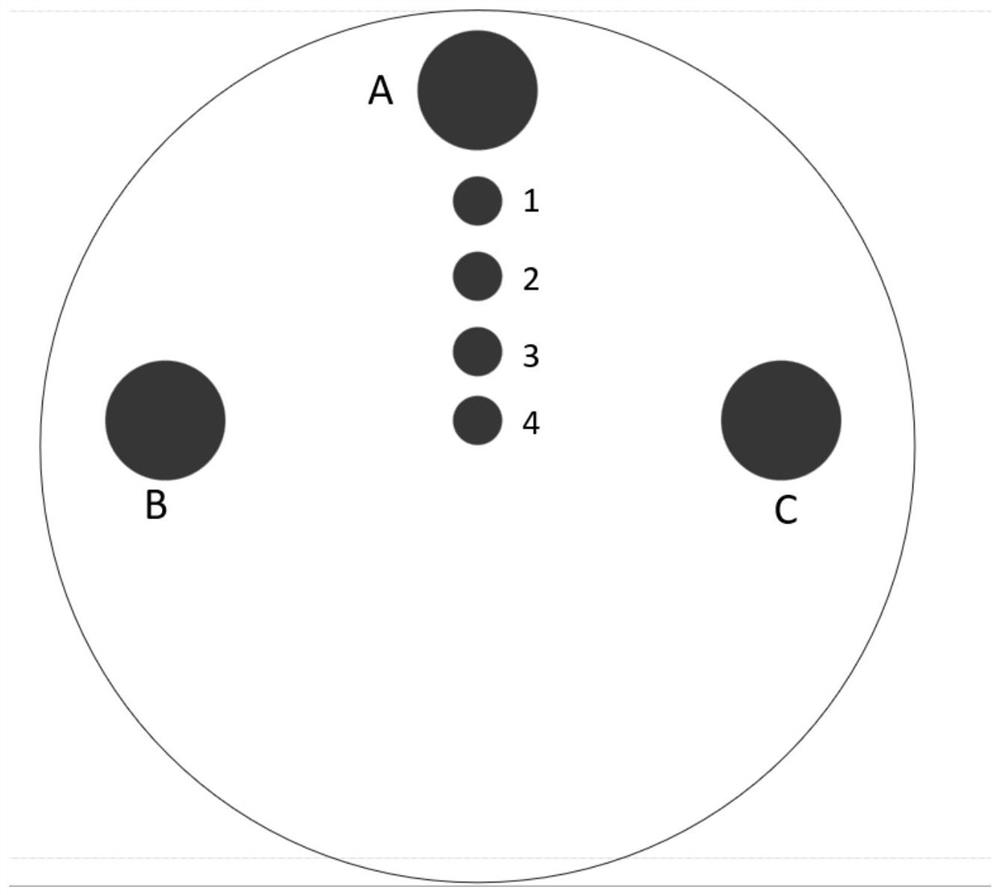
[0036] Such as figure 2 As shown, the target is fixedly connected to the moving target 4, and the target on the moving target 4 is composed of seven red LED lights, and the red fi...

Embodiment 2

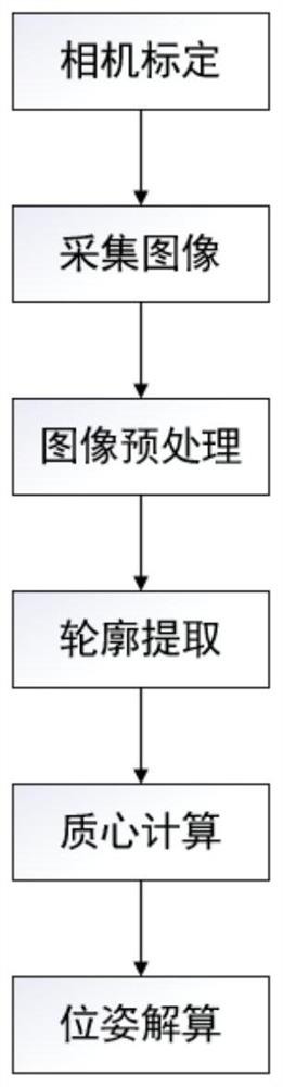
[0038] The pose measurement process of moving target is as follows: image 3 shown, including the following steps:

[0039] Step 1: Camera Calibration

[0040] Camera calibration is required before starting image acquisition. The imaging process of the camera is analyzed, and the pinhole imaging model of the camera is established without considering the lens distortion.

[0041] According to the principle of similar triangles, the transformation relationship between the homogeneous coordinates in the camera coordinate system and the homogeneous coordinates in the image plane coordinate system can be obtained

[0042]

[0043] where (X,Y,1)T is the homogeneous coordinate of the image P' formed by the space point P in the image plane coordinate system,

[0044] (X C ,Y C ,Z C ,1) T is the homogeneous coordinate of the spatial point P in the camera coordinate system, and f is the focal length of the camera lens.

[0045] The homogeneous coordinates of the space point P...


PUM


Abstract

The invention provides a navigation positioning device and method in a spacecraft cluster ground simulation system, and belongs to the technical field of computer vision and image processing. According to the device, a red optical filter is arranged on a lens of an industrial camera in the positioning device; a camera bracket is fixedly connected with the industrial camera and used for supportingthe industrial camera; a moving target performs one-dimensional rotation and two-dimensional translation on a test table; the industrial camera collects an image containing the moving target and transmits the image to a pose measurement PC machine; the pose measurement PC machine calculates the pose information of the moving target in a three-dimensional space according to the two-dimensional coordinates of the image; and a positioning method comprises the steps of camera calibration, image collection, image preprocessing, contour extraction, centroid calculation, pose calculation and the like. According to the invention, multi-target pose measurement can be realized; the operation speed is increased, and the requirement for real-time performance in actual engineering can be met; and the interference in a complex environment can be effectively suppressed, and the anti-interference capability is improved.

Description

technical field [0001] The invention relates to a navigation and positioning device and method in a spacecraft cluster ground simulation system, belonging to the technical field of computer vision and image processing. Background technique [0002] In the paper "Research on a Simple Monocular Vision Pose Measurement Method" (Journal, Gu Fengwei, Gao Hongwei, Jiang Yueqiu, August 2018), aiming at the problem of robot pose measurement under specific working conditions, a simple method based on The pose measurement system of monocular vision proposes a combination of accurate target detection algorithm and monocular vision measurement method, which can realize the measurement of robot pose. Experiments show that the method is accurate and effective, and meets the measurement requirements. Although the proposed monocular vision measurement method can accurately and effectively obtain the target's pose, the designed target cannot be distinguished from multiple targets, so it is ...

Claims


Application Information

Patent Timeline
IPC IPC(8): G06T7/80G06T7/194G06T5/30G06T7/90G06T7/70G06T5/00G01C21/20G01C11/04G01B11/00G01B11/24
CPCG01B11/002G01B11/24G01C11/04G01C21/20G06T5/002G06T5/30G06T2207/10024G06T2207/20024G06T2207/30244G06T7/194G06T7/70G06T7/80G06T7/90
Inventor 夏红伟孙浩然李莉马广程安昊
Owner HARBIN INST OF TECH
Why Eureka
Try Eureka