A real-time positioning system and method for roadway excavation equipment based on multi-sensor fusion

A multi-sensor fusion, real-time positioning technology, applied in radio wave measurement systems, instruments, measurement devices, etc., can solve the problems of inability to obtain all the pose parameters of the fuselage, inability to realize intelligent excavation, inaccurate measurement results, etc. Simple structure, high reliability, and complete body positioning information

Active Publication Date: 2022-08-02
CHINA RAILWAY CONSTR HEAVY IND
View PDF14 Cites 0 Cited by
  • Summary
  • Abstract
  • Description
  • Claims
  • Application Information

AI Technical Summary

Problems solved by technology

[0006] The purpose of the present invention is to provide a real-time positioning system and method for roadway excavation equipment with multi-sensor fusion, so as to solve the problem that the existing coal mine roadway excavation equipment positioning method cannot obtain all pose parameters of the fuselage in the earth coordinate system, real-time measurement is limited, Inaccurate measurement results, unable to realize safe and efficient intelligent tunneling

Method used


Image

  • A real-time positioning system and method for roadway excavation equipment based on multi-sensor fusion
  • A real-time positioning system and method for roadway excavation equipment based on multi-sensor fusion
  • A real-time positioning system and method for roadway excavation equipment based on multi-sensor fusion

Examples


Embodiment 1

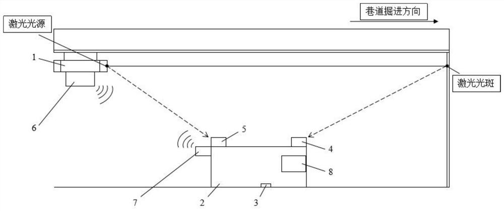
[0067] see Figure 1 to Figure 3 , a multi-sensor fusion real-time positioning system and method for roadway excavation equipment, this embodiment is applied to real-time positioning of excavation equipment in coal mine roadways.

[0068] see figure 1 , a multi-sensor fusion real-time positioning system for roadway excavation equipment, including laser transmitter 1, excavation equipment 2, inertial unit 3, front camera 4, rear camera 5, radar transmitter 6, radar receiver 7 and industrial computer 8;

[0069] The laser transmitter 1 is installed on the roof of the coal mine roadway, and emits a pointing laser along the roadway excavation direction to form a laser spot on the excavation working surface; the excavation equipment 2 is provided with an inertial unit 3, which measures the fuselage of the excavation equipment 2 relative to the ground level. pitch angle and roll angle; the front camera 4 is installed on the front end of the fuselage of the excavation equipment 2, w...


PUM


Abstract

The invention provides a multi-sensor fusion real-time positioning system for roadway excavation equipment, including laser transmitter, excavation equipment, inertial unit, front camera, rear camera, radar transmitter, radar receiver and industrial computer. The invention also provides a real-time positioning method, which adopts a real-time positioning system to establish a space coordinate system; obtains the coordinates of the laser spot in the geodetic coordinate system by pointing the laser; obtains the coordinates of the laser spot and the light source in the fuselage coordinate system; The coordinate conversion relationship between the body and the ground is used to obtain the coordinates of the laser spot and the light source in the geodetic coordinate system; the distance between the ranging radars is obtained; finally, the position and attitude of the excavation equipment body under the geodetic coordinate system is calculated. The invention can realize real-time automatic positioning of roadway excavation equipment without manual intervention in the positioning process, realize safe and efficient roadway excavation, and provide technical support for unmanned and intelligent coal mine roadway excavation equipment.

Description

technical field [0001] The invention relates to the technical field of construction machinery positioning, in particular to a multi-sensor fusion real-time positioning system and method for roadway excavation equipment. Background technique [0002] With the development of coal mine equipment technology, the domestic coal mine roadway has gradually realized mechanized excavation from the previous artificial-based excavation method. However, due to the fact that the positioning technology of the excavation equipment in the roadway has not been broken through at this stage, the coal mine roadway still relies on the visual inspection of the operator. Operation and positioning technology has become the most urgent bottleneck technology in the intelligent excavation of coal mine excavation equipment. [0003] Coal mine roadway excavation mainly adopts cantilever roadheader or fully mechanized roadheader, and cooperates with continuous belt conveying device to realize rapid excava...

Claims


Application Information

Patent Timeline
Patent Type & Authority Patents(China)
IPC IPC(8): G01C21/00G01C21/20G01C21/16G01S17/08
CPCG01C21/005G01C21/20G01C21/165G01S17/08
Inventor 秦念稳肖正航李建华陈晓伟曾苗筠李兆阳张宏
Owner CHINA RAILWAY CONSTR HEAVY IND
Why Eureka
Try Eureka