BIM-based three-dimensional geological modeling and geologic body model-based construction application method

A modeling method and three-dimensional geological technology, applied in the field of geotechnical engineering, can solve the problems of tediousness, low modeling efficiency, lack of calculation and model output interface, etc., and achieve the effect of improving accuracy

Active Publication Date: 2020-11-17
CHENGDU UNIVERSITY OF TECHNOLOGY +1
View PDF4 Cites 7 Cited by
  • Summary
  • Abstract
  • Description
  • Claims
  • Application Information

AI Technical Summary

Problems solved by technology

[0004] (1) Manual input of drilling data and manual modeling of rock and soil layers, the modeling workload is heavy and cumbersome, error-prone, modeling efficiency is extremely low and implementation is too difficult;
[0005] (2) When building a 3D geological model, it can only deal with conventional rock and soil strata, and it is difficult to deal with common phenomena such as lens and pinch-out rock and soil strata, and only rough modeling of rock and soil strata can be performed;
[0006] (3) Using Revit software to simulate foundation pit excavation can only be done manually for one rock an

Method used


Image

  • BIM-based three-dimensional geological modeling and geologic body model-based construction application method
  • BIM-based three-dimensional geological modeling and geologic body model-based construction application method
  • BIM-based three-dimensional geological modeling and geologic body model-based construction application method

Examples


Embodiment 1

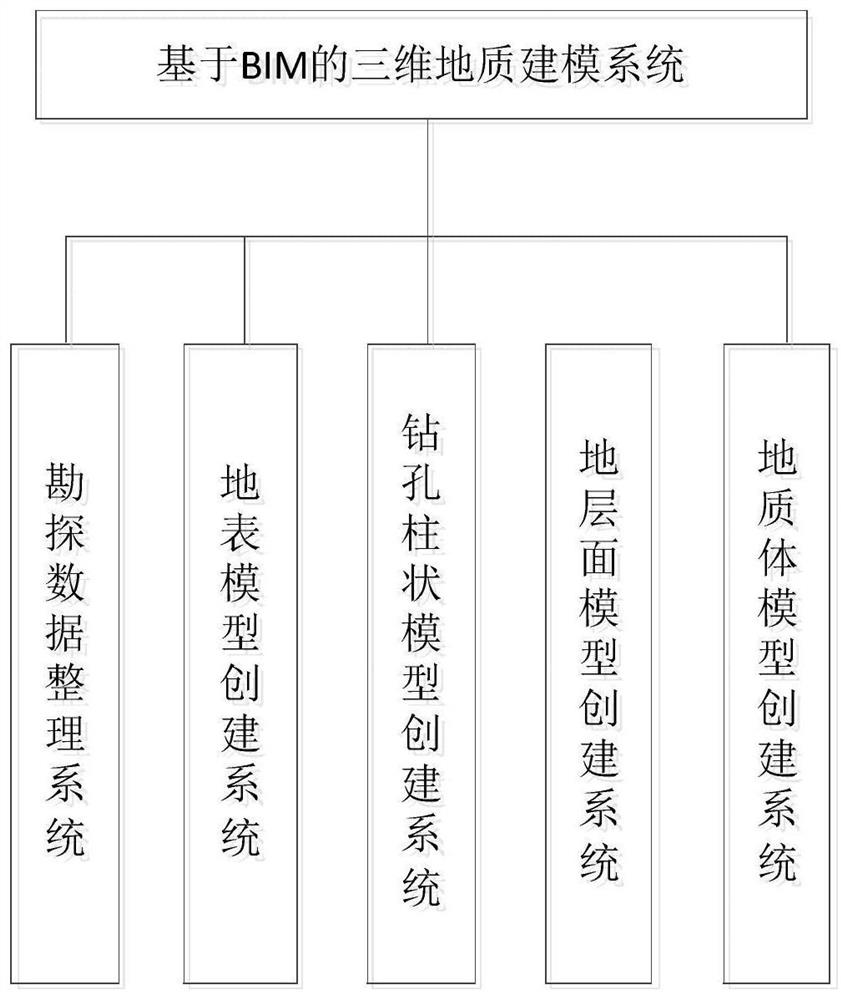
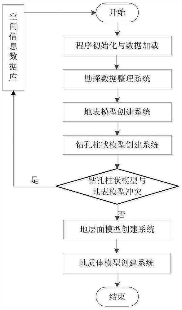
[0084] Such as Figure 1-8 As shown, the BIM-based three-dimensional geological modeling method of this embodiment includes the establishment of a spatial information database according to various types of exploration data, and then the steps of creating a geological body model. The steps of creating a geological body model include:

[0085] Surface model creation;

[0086] Borehole data model creation;

[0087] Ground layer model creation;

[0088] Geological volume model creation.

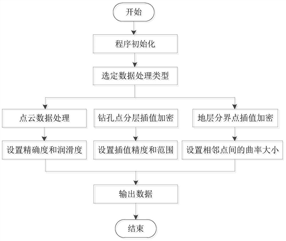
[0089] Due to the surface point cloud data extracted from the spatial information database, there are often more noise points that cannot be directly used to create the surface. At the same time, the accuracy of surface DEM data extracted from satellite remote sensing maps is low, which is not suitable for small-scale accurate modeling, and phenomena such as discontinuous data between formation holes require secondary processing of the data before being used for later modeling.

[0090] There...

Embodiment 2

[0154] Such as Figure 13 , 14 As shown, the construction application method based on the geological body model, according to the geological body model output / stored by the BIM-based three-dimensional geological modeling method, the geological structure phenomenon model is created, and then the geological body model BIM construction application is carried out. The method for creating the above-mentioned geological structure phenomenon model includes the following steps:

[0155] Import the fault line in DWG format, and use the pick spline curve tool that comes with Autodesk-revit to pick the curve;

[0156] Input fault strike, dip and dip parameters;

[0157] The stretching and setting out of the ages is a closed fault plane;

[0158] Input the geological body model, perform Boolean operations on the fault plane and the geological body model, and divide the geological body;

[0159] Write geological related geological attributes, output / store geological structure phenomeno...


PUM


Abstract

The invention discloses a BIM-based three-dimensional geological modeling method and a geologic body model-based construction application method, and the BIM-based three-dimensional geological modeling method comprises the steps: building a spatial information database according to various types of exploration data, and then building a geologic body model; reading exploration data such as modelingarea surface point cloud data or contour lines from a spatial information database, and automatically creating a surface model; connecting the surface model to a Surface.PerimeterCurves node packet,and picking up a terrain surface contour line; shifting the replication contour line to the lowest point height of the stratum; grouping the two edge contour lines, stretching and lofting the two edgecontour lines into a body, and creating a geological entity; importing the stratum surface model, and performing Boolean operation on the geological entity and the stratum surface model; and writinggeological information and outputting/storing the geologic body model. According to the invention, automatic modeling is achieved, seamless butt joint of the building BIM model can be achieved, the simulation performance of traditional BIM application such as early-stage planning design, earthwork calculation and site construction simulation can be greatly improved, and the accuracy of geologicalnumerical analysis is greatly improved.

Description

technical field [0001] The invention belongs to the technical field of geotechnical engineering based on BIM, and in particular relates to three-dimensional geological modeling based on BIM and a construction application method based on a geological body model. Background technique [0002] Geological information usually obtains basic data through drilling and other means, and uses drilling histograms, profiles and survey reports as the main forms of information. This method has long-term engineering experience, and the model and form are more standardized and professional, but it also has certain shortcomings, including inconvenient information access, strong specialization, stacked by a large amount of statistical data, and no effective three-dimensional display effects etc. However, with its powerful 3D rendering capabilities and information integration capabilities, BIM can also interact with a large amount of information with many softwares, and combine with GIS system...

Claims


Application Information

Patent Timeline
IPC IPC(8): G06F30/13G06F30/20
CPCG06F30/13G06F30/20
Inventor 曾鹏黄解放陈洪秦扬张天龙樊华陈毅
Owner CHENGDU UNIVERSITY OF TECHNOLOGY
Why Eureka
Try Eureka