Coastal zone dam stability monitoring and flooding vulnerability evaluation method and system

A coastal zone and fragility technology, applied in the direction of radio wave measurement system, satellite radio beacon positioning system, measurement device, etc., can solve the problems of weakening damage, low spatial resolution, small coverage area, etc., and achieve the minimum economic loss The effects of high-resolution, high spatial-temporal resolution, and improved observation efficiency

Active Publication Date: 2020-11-27
OCEAN UNIV OF CHINA
View PDF4 Cites 9 Cited by
  • Summary
  • Abstract
  • Description
  • Claims
  • Application Information

AI Technical Summary

Problems solved by technology

[0004] (1) Stability monitoring of coastal dams: the main technical methods include precision leveling, triangular elevation measurement, groundwater well monitoring technology, etc., which have the characteristics of high time resolution and high precision, but only limited discrete point observation, space Low resolution and small coverage, while continuous or periodic monitoring requires high manpower and material costs
[0005] (2) Spatial-temporal resolution and accuracy of coastal dam DEM: Most studies mainly consider the submerged range of a large area, so the DEM data used are often relatively low in spatial resolution and accuracy, and are not suitable for fine structure analysis. Inundation analysis of coastal dams
[0006] (3) Inundation vulnerability analysis of coastal dams: A common inundation analysis method is to use a uniform and constant deformation rate to derive the future DEM on the basis of the existing DEM. Most studies did not conduct DEM simulations, but transformed the deformation rate into Relative to the rise and fall of sea level, and assuming that the surface deformation rate is consistent in space and time, there are two obvious shortcomings in water level simulation. One is to use the average water level for inundation analysis, which weakens extreme weather events. damage under
Second, the water level estimate is too high, which amplifies the impact of inundation
[0008] (1) The stability monitoring of existing coastal dams can only be observed at limited discrete points, with low spatial resolution and small coverage. At the same time, continuous or periodic monitoring requires high manpower and material costs
[0009] (2) The temporal and spatial resolution and accuracy of the existing coastal dam DEM are relatively low, which is not suitable for fine-structure coastal dam inundation analysis
[0010] (3) There is no DEM simulation for the inundation vulnerability analysis of the existing coastal dams; the use of the average water level for inundation analysis or excessive water level estimation expands the impact of inundation
[0014] For problem (3), the existing dam inundation analysis does not predict the future DEM of the dam, but converts the dam deformation into the water level change, ignoring the destructive effect of the deformation itself on the dam structure, especially if there is When the vertical deformation is non-uniform, the shear stress generated is more likely to damage the dam and cause seawater intrusion and submersion of internal infrastructure

Method used


Image

  • Coastal zone dam stability monitoring and flooding vulnerability evaluation method and system
  • Coastal zone dam stability monitoring and flooding vulnerability evaluation method and system
  • Coastal zone dam stability monitoring and flooding vulnerability evaluation method and system

Examples


Embodiment Construction

[0085] In order to make the object, technical solution and advantages of the present invention more clear, the present invention will be further described in detail below in conjunction with the examples. It should be understood that the specific embodiments described here are only used to explain the present invention, not to limit the present invention.

[0086] Aiming at the problems existing in the prior art, the present invention provides a method and system for monitoring the stability of coastal dams and assessing submergence vulnerability. The present invention will be described in detail below in conjunction with the accompanying drawings.

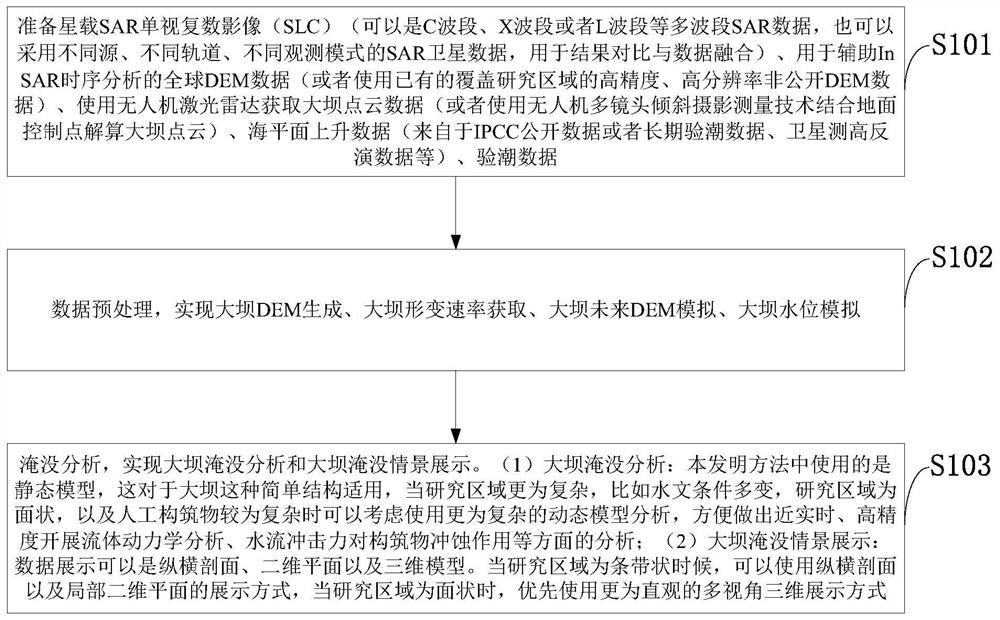
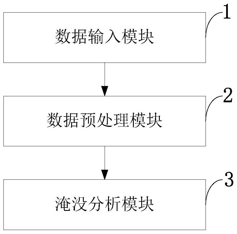
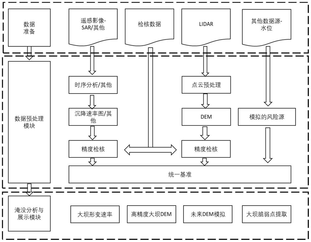
[0087] Such as figure 1 As shown, the coastal zone dam stability monitoring provided by the invention and the submerged vulnerability assessment method include the following steps:

[0088] S101: Prepare spaceborne SAR single-view complex images (SLC) (can be multi-band SAR data such as C-band, X-band or L-band, or use SAR satell...


PUM


Abstract

The invention belongs to the technical field of coastal zone dam monitoring, and discloses a coastal zone dam stability monitoring and flooding vulnerability evaluation method and system. The method comprises the steps of preparing a satellite-borne SAR single look complex image and global DEM data for assisting the InSAR time sequence analysis, and obtaining dam point cloud data, sea level risingdata and tide inspection data through employing an unmanned plane laser radar; carrying out data preprocessing to realize dam DEM generation, dam deformation rate acquisition, dam future DEM simulation and dam water level simulation; and performing flooding analysis to realize dam flooding analysis and dam flooding scene display. According to the invention, the combination of the satellite-borneInSAR time sequence analysis deformation rate and the unmanned aerial vehicle-mounted laser radar DEM is realized, and high observation precision and space-time resolution are ensured. According to the invention, three components (tidal component, storm water increase and sea level rise) are synthesized for flooding water level simulation, daily conditions and extreme conditions are simulated at the same time, and over-high water level estimation is avoided.

Description

technical field [0001] The invention belongs to the technical field of monitoring coastal dams, in particular to a method and system for monitoring the stability of coastal dams and assessing submergence vulnerability. Background technique [0002] At present, coastal dam monitoring is usually affected by the spatial and temporal resolution of observation data, and is limited by human and economic costs. Generally speaking, using traditional ground leveling or satellite navigation and positioning system (GNSS) continuous operation reference station to carry out long-term deformation monitoring of dams can achieve relatively high monitoring accuracy, but it is usually limited by grid density and economic applicability . [0003] The current inundation analysis of coastal dams can be mainly divided into two categories: the first type is based on the premise of stable ground, and the water level of different heights is superimposed for inundation analysis; the second type is b...

Claims


Application Information

Patent Timeline
Patent Type & Authority Applications(China)
IPC IPC(8): G01S13/90G01S13/88G01S13/86G01S7/41G01S17/88G01S17/86G01S7/48G01S19/42
CPCG01S13/9023G01S13/865G01S13/885G01S7/41G01S17/88G01S17/86G01S7/4802G01S19/42Y02A10/40
Inventor 李鹏王国阳李振洪王厚杰
Owner OCEAN UNIV OF CHINA
Why Eureka
Try Eureka