Geographic information management system for mountainous region agricultural planting park

A geographic information and management system technology, applied in the field of geographic information management systems in mountainous agricultural plantation parks, can solve problems such as inadequate management and insufficient intelligent informatization, reduce investment, improve park management efficiency and accuracy, and improve soil conditions Effect

Inactive Publication Date: 2021-01-22
贵州省山地资源研究所
View PDF8 Cites 4 Cited by
  • Summary
  • Abstract
  • Description
  • Claims
  • Application Information

AI Technical Summary

Problems solved by technology

[0005] Aiming at the deficiencies of the prior art, the present invention provides a geographic information management system for mountainous agricultural planting parks, which solves the problems of inadequate management and insufficient intelligent informatization caused by fragmented planting of mountainous agricultural

Method used


Image

  • Geographic information management system for mountainous region agricultural planting park

Examples


Embodiment

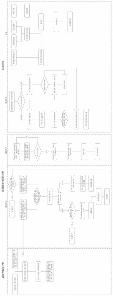
[0030] Such as figure 1 As shown, the embodiment of the present invention provides a geographic information management system for mountainous agricultural plantation parks. The present invention uses geographic information systems (GIS) as a base to integrate unmanned aerial vehicles, and equipment such as monitoring establishes a set of geographical information management methods for agricultural plantation parks, including Manage big data analysis module, irrigation equipment IoT control module, equipment maintenance module and daily inspection module.

[0031] The Irrigation Equipment IoT Control Module is to establish the communication between the geographical information management system of the agricultural plantation area and the IoT Controller. The IoT Controller connects with the soil monitoring (water, fertilizer content) equipment and the irrigation equipment. Command to start irrigation facilities or prompt manual processing. The specific operation method of the i...


PUM


Abstract

The invention provides a geographic information management system for a mountainous region agricultural planting park, and relates to the technical field of agricultural management. According to the agricultural planting park geographic information management system, a geographic information system (GIS) is used as a substrate to integrate equipment such as an unmanned aerial vehicle and a monitorto establish a set of mountain agricultural planting park geographic information management method, and a management big data analysis module, an irrigation equipment Internet of Things control module, an equipment maintenance module and a daily patrol module are included. By arranging the big data analysis module, the irrigation equipment Internet of Things control module, the equipment maintenance module and the daily patrol module, automation and self-energization of informatization management of the agricultural planting park are achieved, the park management efficiency and accuracy are improved, the crop planting cost and labor intensity are greatly reduced, and no dead corner exists in park management and nursing.

Description

technical field [0001] The invention relates to the technical field of agricultural management, in particular to a geographic information management system for mountainous agricultural plantation parks. Background technique [0002] Agriculture is an industry that uses the growth and development laws of animals and plants to obtain products through artificial cultivation. Agriculture belongs to the primary industry, and the science that studies agriculture is agronomy. The objects of labor in agriculture are living animals and plants, and the products obtained are the animals and plants themselves. Agriculture is the basic industry that provides support for the construction and development of the national economy. In a broad sense, agriculture refers to five industrial forms including planting, forestry, animal husbandry, fishery, and sideline; in a narrow sense, agriculture refers to planting. Including the production activities of crops such as food crops, commercial cro...

Claims


Application Information

Patent Timeline
Patent Type & Authority Applications(China)
IPC IPC(8): G06Q50/02G01N33/24G16Y10/05
CPCG06Q50/02G01N33/24G16Y10/05
Inventor 吕思思赵卫权李威杨家芳孙小琼黄亮赵祖伦谢冬冬
Owner 贵州省山地资源研究所
Why Eureka
Try Eureka