
Semantic segmentation-based surface feature recognition and classification method and device

A technology for semantic segmentation and feature recognition, which is applied in the fields of ecological environment science and geographic information, and can solve the problem that high-resolution remote sensing image datasets have not achieved ideal results.

Active Publication Date: 2021-03-09
COMP NETWORK INFORMATION CENT CHINESE ACADEMY OF SCI
View PDF20 Cites 6 Cited by
  • Summary
  • Abstract
  • Description
  • Claims
  • Application Information

AI Technical Summary

Problems solved by technology

Although these methods perform well on benchmark datasets such as PASCAL, Cityscapes, and ADE20K, they do not achieve satisfactory results on high-resolution remote sensing image datasets

Method used


Image

  • Semantic segmentation-based surface feature recognition and classification method and device
  • Semantic segmentation-based surface feature recognition and classification method and device

Examples


Embodiment Construction

[0059] The present invention will be further described below through specific embodiments and accompanying drawings.

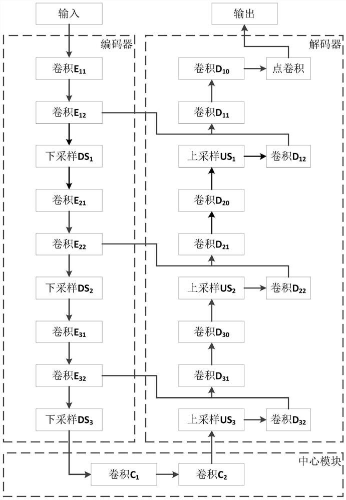
[0060] The model structure of a feature recognition and classification method based on semantic segmentation in this embodiment is as follows figure 1 shown. The following is a detailed description of land type identification using Sentinel-1 satellite SAR radar data and Sentinel-2 satellite multispectral data as an example.

[0061] The first step is to read multi-source remote sensing images for earth observation and establish a sample data set. The multi-source remote sensing images for earth observation in this example include SAR radar image data of Sentinel 1 satellite, multispectral image data of Sentinel 2 satellite and land classification data of MODIS satellite from 2016 to 2017, with a total of 541,986 images. Among them, the SAR radar image of Sentinel-1 satellite includes two channels of VV and VH, and the multi-spectral image of Sentinel-2 sate...


PUM


Abstract

The invention discloses a semantic segmentation-based surface feature recognition and classification method and device. The method comprises the following steps: 1) acquiring multi-source remote sensing data of each region, and combining the data of the same region into a sample to obtain a sample set; 2) establishing a semantic segmentation model; training the model by using the sample set, wherein the semantic segmentation model is formed by connecting an encoder, a central module and a decoder in series; the encoder is formed by connecting N encoding modules in series, the decoder is formedby connecting N decoding modules and a point convolution module in series, and the center module is formed by connecting a convolution module C1 and a convolution module C2 in series, and each encoding module El is formed by connecting a convolution module El1, a convolution module El2 and a down-sampling module DSl in series, and each decoding module D1 is formed by connecting an up-sampling module USl, a convolution module Dl2, a convolution module Dl1 and a convolution module Dl0 in series; and 3) processing the remote sensing data to be identified by using the trained model to obtain an identification result of the ground object type.

Description

technical field [0001] The present invention relates to the fields of geographic information, ecological environment science, remote sensing and computer technology, and specifically relates to a method and device for identifying and classifying features based on semantic segmentation. Background technique [0002] Recognition and classification of ground objects mainly use images obtained from earth observation to identify the category of each pixel in the image through semantic segmentation, and then realize road extraction, building detection, forest change monitoring, land type recognition, etc. Resource investigation, agriculture, forestry, ocean, land management, urban planning, topographic mapping, disaster reduction and prevention, environmental pollution, climate change and other fields have a wide range of applications, and are of great significance to the sustainable development of human beings. [0003] The use of earth observation images for ground object recogn...

Claims


Application Information

Patent Timeline
IPC IPC(8): G06K9/00G06K9/62G06N3/04G06N3/08G06T7/10
CPCG06T7/10G06N3/08G06T2207/10032G06V20/13G06N3/045G06F18/214Y02A90/10
Inventor 李峥赵江华王学志
Owner COMP NETWORK INFORMATION CENT CHINESE ACADEMY OF SCI
Learn More